The slow continental drifting of landmasses are called tectonic plates (or lithospheric plates) and they drift across the lines of latitude and longitude. The tectonic plates have been moving since the beginning of time. Movement of the tectonic plates affects the oceanic and atmospheric circulation, climate, storm tracks, and the duration and timing of seasons. Each year, the tectonic plates move slowly across the Earth by several inches. When the continents collide, one plate will usually be forced underneath the other plate, which will result in the upthrust of mountain chains. Movements of these faults can turn a flat plain into a massive mountain range. As the mountains take form, biomes begin to develop along their slopes.
Located west of Tucson, Arizona, the Tucson Mountains is not impressively high as they only reach up to 4,687 feet. They may be short in stature, but they are big in beauty. The Tucson Mountains are the remains of a collapsed volcano ranging 15 miles long. Towering stratovolcanoes erupted here ejecting hot volcanic debris about 70 million years ago. The Tucson Mountains were pulled westward for miles across the detachment fault to where they are today. As I stated before, the Tucson mountains were once a volcano located on the western side of the Santa Catalina Mountain. For 20 miles, the top of the volcano slid to the west and formed a valley between the Tucson and Santa Catalina Mountains. The occurrence of detachment faulting was discovered by scientists from the University of Arizona in the Santa Catalinas.
The Tucson Mountains are composed of an extrusive ingenious rock created by the eruption of the volcano called rhyolite.
About 70 million years ago, a massive volcano formed where the Santa Catalina Mountains are today. The volcano then created a circular basin called a caldera after it collapsed on itself. Then 40 million years later, detachment faults caused the upper part of the caldera to slide 20 miles off the lower region due to detachment faults. The creation of the faults produced mountain ranges and valleys. This caused Tucson to drop 3,300 meters down, creating the valley that has since been filled with 1,650 meters of sediment. The upper caldera became the Tucson Mountains, while the lower caldera and underlying granite that was left higher on the north side of the valley became Rincon Mountains and Santa Catalina Mountains.
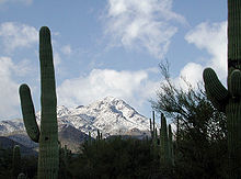
The Santa Catalina Mountain lies north and northeast of Tucson, Arizona. It is often referred to as Catalina Mountain or Catalinas. The highest point in Catalina Mountain is Mount Lemmon with an elevation of over 9,157 feet above the sea level. Annually, this region receives about 180 inches of snow. The Catalina is the most prominent of the other five regions. One of the most popular activities on this mountain is hiking. The Santa Catalina Mountain is composed of an intrusive ingenious rock formed from the solidified magma below the volcano called granite.
The Rincon Mountains is one of the five mountains surrounding the Tucson valley located on the east of Tucson, Arizona. The sun rises on the east side of the Rincon Mountains. The mountain is steep and rugged with many rocky ridges and deep canyons to explore. It is composed of a highly eroded mass of bedrock known as a metaphoric core complex. The Rincon Mountains' highest peaks include the Mica Mountain with an elevation of 8,664 feet and Rincon Peak at 8,482 feet. The Mica Mountain's high elevation supports the spruce vegetation and Ponderosa Pine, while lower elevations have oak-pine forests. Some special places to explore in this mountain include Rincon Mountains Wilderness and the Saguaro National Park, Rincon Mountain District. Rincon Mountains also provides many hiking trails to explore including Douglas Spring Trail, Rincon Peak, Cactus Forest Trail, etc.
The Santa Rita Mountains lie south of the Tucson Basin. It has the highest point in the Tucson area with the highest peak at Mount Wrightson with an elevation of 9,453 feet. Within the range is Madera Canyon that is used as a resting area for migrating birds and is a premier bird-watching area. Santa Rita Mountains is also home to "El Jefe," an adult male jaguar that was first identified in 2011. Santa Rita Mountain also contains trails like the Bog Springs Trail, Cave Creek, and Old Baldy Trail.
The Tortolita Mountains are located northwest of Tucson, Arizona. Its highest peak elevation is 4,696 feet. Established in 1986 by the Pima County, the Tortolita Mountain Park protects most of the mountain range.
Riparian zones encompass the vegetation and wildlife around a body of water such as rivers, creeks, washes, etc. Riparian zones are a crucial part maintaining various ecosystems and preserving wildlife native to the Sonoran Desert. Many species that call Arizona’s Sonoran Desert their home rely on a riparian area at some point in their lives; it is said that 60-70% do. Compared to other riparian areas in the United States, the difference between an upland and a riparian terrestrial system in the southwest United States is not as defined. Other parts have a more gradual change in zones due to the amount of precipitation in the area, meanwhile in the southwest less rainfall occurs. Not only are riparian zones home to many species there are also many benefits that come from a healthy and prosperous riparian area. In riparian areas air temperature can be reduced, the riverbanks have greater protection from erosion, and water and soil qualities are improved. Some examples of a riparian community in the Arizona Uplands include Cienega Creek, San Pedro Riparian, Gila Box Riparian, Salt River Canyon Riparian, and Sonoita Creek.
Cienega Creek is located within Las Cienegas National Conservation Area in a zone between the Sonoran Desert and the Chihuahua Desert. Las Cienegas National Conservation Area contains rare vegetation which contributes to some of its rare habitats. Some of these habitats include cienegas, cottonwood-willow riparian forests, mesquite bosques, semidesert grasslands, and sacaton grasslands. These habitats are home to many species of animals and plants that depend on this riparian for survival.
San Pedro RNCA - Fairbanks AZ 2018-07-21 12-04-57 (41979141630)
The San Pedro Riparian National Conservation Area lies on 57,000 acres of public land. The San Pedro Riparian consist of 40 miles of upper San Pedro River. This riparian area is abundantly populated with vegetation and animals containing many native species including more than 80 mammal species, 40 amphibian and reptile species and many bird species both breeding and migrant.
The Gila Box Riparian National Conservation is an area, approximately 23,000 acres, filled with many different species of creatures and vegetation. Large cottonwoods, sycamores, and willows are some of the various plant life that can be found within the area that make up the riparian forest. The Gila Box Riparian National Conservation has four perennial waterways that all join together to create the Gila Box Riparian. These include Bonita creek, Eagle creek, the Gila River, and the San Francisco River. Considering that four waterways make up this area, there are countless numbers of plant and animal species that make the riparian unique.
The Salt River Canyon is filled with breathtaking geological formations. These formations include salt banks, granite, sandstone, quartzite along with cliffs and creeks. Within the canyon are canyon creek faults and cherry creek faults. Like many riparian zones, the Salt River Canyon Riparian has a diverse array of wildlife and vegetation. With approximately 32 miles of river there is lots of room for a large riparian corridor.
Sonoita Creek lies within the Sonoita Creek State Natural Area or also known as Patagonia-Sonoita Creek Reserve. Sonoita creek spans about 2.8 miles and is filled with a variety of vegetation within its riparian forest and animal species that inhabit it. There are many uncommon plants found within the area including mixed deciduous broadleaf riparian forest. Animal that are found include 36 species of amphibians and reptiles, 49 damsel and dragonfly species, 130 butterfly species, 5 bats and a high diversity of 106 bird species making this location an excellent birdwatching haven. Sonoita Creek flowing from the Santa Cruz River is also home to a rare native fish called the Gila Topminnow.
The Hadley Cell is a global scale tropical atmospheric circulation that features air rising near the Equator, flowing poleward at a height of 10 to 15 kilometers above the earth's surface, descending in the subtropics, and then returning equatorward near the surface. This whole process starts out because the equator region receives a higher amount of sun radiation so there is warmer air and lots of evaporation there. The whole region is usually very humid because warm air is capable of holding more moisture than cool air. Warmer air tends to rise and it will do so until it gets to about 10 to 15 kilometers high. As air rises temperature decreases and there is a lot of precipitation event as the air massed rise and and start to hear towards the North and South. Air masses will continue flowing southward and northward but as they do they will get drier and drier because of the rain events and also colder and colder since they are leaving the equator and going towards the poles at around 30° South and 30° North. Air masses tend to descend towards the planet's surface resulting in these regions being dominated by dry air without much precipitation. This creates the perfect environment for deserts to form.
Rain shadow effect
* around 30° North and South of the Equator
* interior of continents (this is because they may be farther from the main sources of moist air like oceans)
* rain shadows of large mountain belts (perfect settings for deserts to form)
**The Mojave, Black Rock, Sonoran, and Chihuahuan deserts all are in regions which are rain shadowed.
According to C. Hart Merriam, life zone was developed to describe areas with similar plants and animals communities. This changes are observed when there is an increase in latitude but a constant elevation and also an increase in elevation at a constant latitude.
Upper Sonoran is described as desrt steppe or chapparral and transition which are like open woodland. it contains grasslaands and woodlands. Some common mammals include the Pronghorn (Antilocapra americana), sometimes wrongly called antelope, the Cliff Chipmunk (Tamias dorsalis), and Black-tailed Prairie Dog (Cynomys ludovicianus). Some of the plants found in the upper soronan is sagebrush, scrub oak, Colorado pinyon,
One of the greatest natural resources used in today's society is copper. Copper is used as a conductor, construction, and industrial machinery. The Rosemont Mine is a large open copper mine located in Arizona near Pima County built by Hdbay Minerals. This mine is located within the Coronado National Forest and Santa Rita Mountains which are valuable habitats for native animals and plants. This mine is not open yet due to legal allegations made for the protection of the environment. The arguments against the mine consist of destroying the Cienega Creek watershed, contaminated mine runoff worsening water quality, destroying natural habitats, endangering wildlife, and causing regional air pollution. Proponents suggest the mine will create jobs, generating more revenue, and decrease the dependency on other countries for copper. The geological area contains around 550 million tons of 0.45% copper with molybdenum, and silver credits. This area is dominated by Precambrian granite, Paleozoic, and Mesozoic sediments. The Paleozoic sedimentary carbonate units are host rocks for copper mineralization. The units include conglomerates, sandstones, and siltstones. The existence of porphyry copper deposits in this area suggests there were granitic intrusions and felsic volcanic eruptions during the Laramide orogeny (period of mountain building). During this period both low-angle thrust and high-angle slips extended tectonic activity causing volcanic eruptions which led to copper deposits as well as the creation of basin and range in the southwestern region.
The Tucson Mountains range form part of the Arizona Uplands, they are now widely protected since they are within the limits of national parks. These mountains were once mined for various metallic elements. Totaling up to over 120 mines throughout these mountains. The ores and minerals in this location derived from volcanic eruptions.
Minerals found in this region:
*Copper
*Gold
*Lead
*Mineral specimens
*Molybdenum
*Silver
*Vanadium
*Zinc
Ironwood Forest National Monument 2016 1Silverbell Mine Pima County Arizona 2014
The Ironwood Forest National Monument is located in Pima county near Tucson, Arizona. This forest is 188,819 acres which contain many important cultural features: 200+ Hohokam sites, cattle grazing, and mining. Threatened species like Ferruginous pygmy owl, desert bighorn sheep, lesser long-nosed bat, Turk's head cactus also reside in this area. This location is constructed of Basin & Range Province, Roskruge Mountains, Samaniego Hills, Sawtooth Mountains, Silver Bell Mountains, Sonoran Desert, and Western Silver Bell Mountains.
The Silver Bell Mine is located in Silver Bell Moutain portions of the Ironwood Forest. This mine has been operational for over the past 130 years and it is still one of the mines used for copper. The mine has major porphyry copper deposits which most of the mining revolves around the copper. Other deposits that have been found in this area and are now minor productions are silver, molybdenum, zinc, lead, and gold. Over the past several years the Silver Mine has produced: 2.27 billion pounds of copper, 6.6 million pounds of molybdenum, 3.7 million pounds of lead, 40.8 million pounds of zinc, 2,100 ounces of gold, and 5.95 million ounces of silver.
Mexico has an abundance of natural resources. Some of these resources are found in the Sonoran Plains region. This region was a site for various minerals. The most abundant have been copper, silver, and lead. In the area near Hermosillo, Sonora there have been seventeen mines and seventeen occurrence locations. These regions have had copper, gold, iron, lead, molybdenum, quartz, silica, silver, and tungsten.
La Colorada Mine is a gold mine located in the state of Sonora near Hermosillo. This mine is an open-pit mine that is still functional. The primary commodities found are gold and silver, as well as secondary commodities: copper, lead, and zinc. This mine has been divided into different districts based on its' deposits. There is the Creston deposit, Gran Central deposit, La Colorada Deposit, and Veta Madre zone.


.jpg)


