History of Grand-Popo
Please share your thoughts about whether to keep this book at Wikibooks. Maintain this notice so this book can receive a fair review and people have time to boldly address reasonable concerns through concrete improvements. Remove or replace this notice after discussion concludes and a community decision is made. Please also consider notifying the primary contributors on their discussion page with
|
The history of Grand-Popo relates to the Mono River estuary of the Bight of Benin and its surrounding areas. The present - day Grand-Popo District extends to the west as a sea-river lane to the Togo border. Just across the border is also the historic city of Togo, Aného, formerly known as Little Popo, Klein Popo or Petit-Popo, depending on the speaker's language. Located east of Grand-Popo, where the Mono river joins the Gulf of Benin is called the "Bouche du Roi" ("the King's mouth"). The narrow peninsula on the Gulf of Benin separates the chain of tributaries and lagoons flowing from the Mono river, stretching westward from Little Popo to historic city of Ouidah. Depending on the amount of water, it was an important transport route in the region. To the northeast of "Bouche du Roi" is a rugged area formed by marshes, rivers and lakes that protected the area against external enemies.
The Kingdom of Grand-Popo was not originally a united kingdom, but a collection of several villages with a sandy ravine that separated the lagoon from the sea. The center of Grand-Popo, Gbebco, was once located about 6.4 kilometers west of Bouche du Roi. Carrefour, the highway junction where the village center is now located, is 17 kilometers from the mouth of the river. On the other side of the lagoon is Hevé, which was originally a harbor area. Agbanaken was the king's residence and capital. It was on the western bank of the Mono River, where the river expands into a lagoon. Agbanaken is located beyond the border of what is now Togo.

Origin of the Name
[edit | edit source]The western part of so called "Slave Coast" is originally a cultural and ethnic area of the Hula people. European merchants used the name "Popo" from their kingdom, and from the 17th century it became known as Grand-Popo.
The origin of the name Grand-Popo has been much discussed by scholars. Silke Strickrodt (2015) speculates that this is not a derivative of the indigenous or Portuguese language. According to Robert Law, who studied the history of the region, the first European merchants, the Portuguese, borrowed the word from the Yoruba speaking peoples who lived on the eastern end of the Slave Coast. The Yoruba referred to their Western neighbors, who spoke Gbe. According to Law, the Yoruba word may have come from the name and title of the King of Tado, a kingdom about 62 kilometers inland, generally regarded by the Hula and Gbe speaking peoples as the home of their ancestors and who once ruled the area.[2]
Law thinks the names 'Fulao' and 'Foulaen' probably mean 'Hula', or an alternative to 'Pla', which is an ethnic group name (belonging like phon and hueda, in the Gbe language family) traditionally derived from Grand-Popo (whose real, native name is actually Hula) and who moved east to various locations along the coast.[3]
In 1627, the Spanish missionary Alonso de Sandoval used the word "el Popo" (Popo), thate maent both the king, as well as the area under his control. A strong inland kingdom also had a beach town along the River Aguato, probably it was Grand Popo, Mono River and the Bouche du Roi.

In the late 16th century, Portuguese documents referred to Mono and Bouche du Ro as the "River of Popos". However, Europeans visiting the coast in the 18th century said that Popo was not what the natives called the place or themselves, but they called it "Pla" or "Fla". The Danish governor of the Gold Coast referred to it in the 1720s: "Afra, or Popo, as the whites call it." In the 1780s, Isert pointed out that "Great Popo ... is now called Afla in these areas". In the early 19th century, an English merchant called it Grand Popo or Iffla. The name Pla (also known as Plah or Phla) was established and according to a local priest who collected oral tradition, Pla derives from the word "pou" which means sea. Research on people living in the area has commonly used the word "Hula" (sometimes also Xwla), used by Fons of their eastern backgrounds. This word also refers to the sea.[4]
According to Jones and Sebald, the name Popo (Papoues, Poupous) is mentioned in Portuguese documents in the mid-16th century and it was used both as a place name and as a generic term for a group of people.[5]
The Genesis
[edit | edit source]
The Hula and the coastal Gbe peoples came from the old city of Tadon. According to one story, the ancestor of the Hula people was the oldest of the three brothers in the royal family. The brothers fled their city after one of them had killed the pretender, who was his rival. They founded a settlement called Adja-honoue, which is now about 25 kilometers southeast of Tado. After the plan was revealed, the refugees had to move again. The brothers decided to divorce, and Avlekpo, Hula's ancestor, fled to Adamée on the River Mono and his brothers fled to Dodomee and Allada. They became the ancestors of the Fons.
The pursuers of Tadon followed the brothers, and Avlekpo's people had to flee again to Agbanake by the river.[6] Upon arriving there, Avlekpon is said to have heard a strange, loud voice. He asked his fortune teller the reason for this, and received the answer that the sound was from liquid, from water, and there was no need to fear it. Avlekpon went to the place where the sound came from, and the powerful swells flooded the beach. For the first time he saw the sea, and Grand-Popo was established there. According to the instructions, the king washed himself in seawater, which the fortune-teller said would bring great wealth. From this time onwards, the sea was worshiped by the Hula.
Avlekpon waited in vain for his promised prosperity. During the reign of his grandson Kposs, European merchants arrived and they were well received promising to come back. When they returned, they brought with them many gifts, fabrics, farm equipment, and seeds that they demanded to be planted. Kpassi planted seeds to Agoue, which was about 12 kilometers from Agnabaken, and was established for this purpose. European merchants returned, bringing cowries (which was money) and table salt to pay for farm products.[7]
Pre-colonial time
[edit | edit source]Spread of settlement
[edit | edit source]
Portuguese transactions on the Slave and Gold Coasts began around 1470. The first trade agreement between Grand-Popo and Portugal had already been made in 1533, although it was not until 1553 that their contacts with Gbe speaking people were reported in the Papouée, or Popo region. Thereafter, the Portuguese also communicated with the kingdom of Akkada (Ardra), north of Grand-Popo , which at the time had a hegemonic dominance in the region. Slaves from that region, known as Aradas or Aratas, were documented in Peru around 1565.[8]
From time to time the Portuguese bought slaves from the Grand- and Small-Popo areas, as did the Dutch, who gained the leading European trading power in the area from the 1630s. European documents begin to distinguish in 1659 Grand Popo and Little Popo, although it is not always clear which is meant. According to Robin Law, the appearance of two harbors in the mid-17th century was mainly due to their key role in the lagoon trade that African canoe rowers did, rather than direct trade with European ships. Trade increased as the population moved east from the Gold Coast. One of the groups came from the Ga-Adangme area to Glidji, which is associated with the conquest of the Accra by the Akwamuiden. Another group came from Elmina to the Little Popo coast.[9]
From Grand-Popo, the Hulas spread east and west across the lagoon, establishing new villages. Eventually, their settlements spread off the coast for more than 152 kilometers. By the mid-17th century, however, the area was politically fragmented when the eastern settlements were no longer under the control of the kings of Tad and Grand-Popo, and Allada became the most powerful state on the Slave Coast. By 1670, Grand Popo also remained under Alladan control, but it regained its independence by the 1680s.[10]
Unstable times
[edit | edit source]
Grand Popo's political position was unstable in the late 17th century. From the West Bank of the Volta river came robbers who burned the Dutch base, forcing Grand-Popo to ally with the Kingdom of Hueda (Ouidah). Ouidah appointed a ruler to Grand-Popo, submitting it as the king's puppet ruler. However, the new king rebelled against Hueda's commander-in-chief, who organized a crackdown on the region, which was also attended by the French. The attack failed, in part due to the Grand-Popo lagoon and river environment, which provided support for the region's defense. The French supported Hueda because the English, with whom France was at war at the time in Europe, allied themselves with the French enemies, the Ga tribe in Little Popo in the west. The King of Hueda was still trying to recruit mercenaries against Grand-Popo without success.[11]
The people of Ouidah also sought refuge in the Grand Popo region in the late 1720s as the Kingdom of Dahomey became stronger and conquered Ouidah, as well as Allada. The Dahomese troops followed the Ouidahs, but did not completely subdue the territories of Grand Popo. In the center of the Hula Kingdom was a Dahomeyan population, located north of the lagoon about 400 meters east of the Aho River. This was the customs station in Ahodenu, where the customs going to Ouidah were collected.[12]
Grand-Popo was constantly facing pressure from intruders, especially in the eastern region. The waterways were a natural means of defense against the Dahomey troops who sought to take control of the entire coast.
Religions
[edit | edit source]
One of the early depictions of Europeans said of the settlement of the Grand Popo area: "A village where blacks have a white flag".[13]
Three Spanish Capuchin missionaries visited Grand-Popo in 1660-61. In the 19th century, Methodist missionaries became active on the Slave Coast, and in the 1840s and 50s missionary stations were established in Little-Popo, Glidji, Agouée, and Grand-Popo. At the same time, Catholic missionaries also came to the area. To their surprise, they noticed that there was already a significant Catholic community on the coast. They were known as "Brazilians", or Agudas, who were Africans, often former slaves, who had lived in Brazil. About 4,000 of them had emigrated to the Gulf of Benin by the mid-19th century. They spoke Portuguese, practiced the Catholic religion and used Brazilian names.[14]
Coastal livelihoods
[edit | edit source]Slave trade
[edit | edit source]Grand-Popo participated in the African-European slave trade from the late 16th century. Slaves were transported by canoes to the lagoon and rivers to Ouidah and thence by slave ships to the Americas. The region also provided food to both European traders and enslaved Africans while on the coast and in transit. In the 19th century, the region offered merchants an alternative outlet, as more established marketplaces were in trouble as hotspots for the illegal slave trade. The slave trade benefited not only the Europeans, but also the coastal communities who traded as intermediaries who sold slave Africans from inland to European traders, but also as slave captors. Sometimes slaves sold to Europeans were chosen from the communities themselves.
From the 1680s, the area between the Mono and Volta rivers was directly involved in the slave trade started by Gat in Little Popo and Adangmet in Keto who had moved to the area. Unstable conditions in the late 17th century made it difficult, but did not stop trading. In addition to the English Royal African Company, a German Brandenburg African Company with a factory in Little Popo entered the slave market. The Dutch West Indian trading company re-established its base in Grand-Popo in 1688.[15]
By the end of the 17th century there were almost 50 European marketplaces along the coast. The German Brandenburg African Company had bases in Calabar, Ouidah, Aného (Little Popo) and Grand-Popo for slave cargo.[16]
The supply of slaves was uncertain and it was made more difficult by competition between Dutch and English companies. Ouidah was the largest slave port, and it was estimated that in 1688 the Grand and Little-Popo could supply only 300 slaves a year. More slaves were captured in the context of the local wars. The Portuguese were unsuccessful in the slave trade, but their position changed in the early 18th century as gold was found in Brazil and demand for tobacco increased. In 1698 the Danish ship Københavns Børs appeared on the coast carrying 506 slaves. Prior to 1690, the region attracted only small players in the slave trade, such as the Portuguese, Brandenburgers and Danish, who were unable to compete with the English, French and Dutch in the major slave markets such as Offra and Ouidah. The supply of slaves was sporadic because there was no large expansionist state like Dahomey in the area that could expand markets as a result of the wars. Little-Popo's hinterland in the Atakora Mountains of Togo was impossible to merge with inland trade, unlike Oyo and Porto-Novo in the east.[17]
Between 1702 and 1772, Akawamu and Dahomey invaded the Slave Coast, as a result of which communities moved elsewhere as war and looting spread to the area. During these times, military kings, such as Ashampo (ca. 1737-1767), who was very successful, played a central role. However, the relationship between Ashampo and Europeans was problematic and complicated.[18]
Fishing
[edit | edit source]The economy of the Hula community was based on fishing and salt production. In addition to fish, crabs, shrimps and oysters were also obtained. The fish were dried and shipped inland. Although the word hula means sea, they had no interest or technology in sea fishing. The lagoon and river were rich in fish. Sea fishing was not introduced until the 19th century. In some seasons, seawater also extended to the lagoons, when the water became saline, offering sea fish as well. Fishing equipment included canoe nets, fishing nets made of cotton twine and basket weaves, and later various spears, trawl nets and fishing rods, as well as hand fishing.[19]
Fishing and fish processing
[edit | edit source]Photographed in Avloh, Grand-Popo in December 2017.
-
 Fisherman in the Bouche du Roi area.
 -
 Sorting of fish for frying.
 -
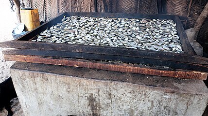 The fish is smoked and baked dry.
 -
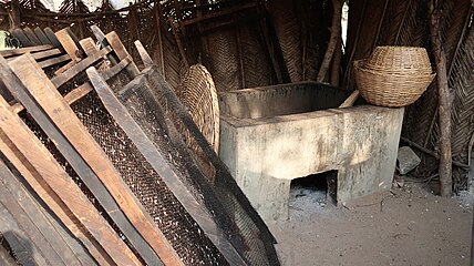 Fish drying and smoking equipment.
 -
 Fish smokehouse.
 -
 Sea fishing boat and fishermen's huts on Grand-Popo beach. Sea boats and sea fishing came to the area in the 19th century.


Preparation of the salt
[edit | edit source]Salt production was a major industry and it was sold to inland. The salt was obtained when the lagoon was dry by scrubbing the soil at its bottom, which was collected in heaps. As the water rose, they were transferred to villages and warehouses. The gathered material was collected in containers about 1.2 meters in diameter, where it was watered and sieved with basket weaves. The water was boiled over the ovens, which were heated by burning the mangrove branches and palm seed skins.[20]
Salt preparation
[edit | edit source]Filmed on "Salt Island" in Grand-Popo, December 2017.
-
 Container with salt raw material.
 -
 Salt raw material storage area.
 -
 The fuel
 -
 The salt is made by boiling the liquid.
 -
 Boiling the salt.


Agriculture and Livestock
[edit | edit source]The nature of Grand-Popo was poorly suited to agriculture and there were few tools. In the 1840s, yam or manioc, cotton and indigo were grown in the area. The corn was the main course of the Grandpopeans, along with the fish. The area further grown sweet potato, ruokabanaania, banana, lablab bean- ( lablab purpureus ) and lentils, okra, shallots, cashew nuts, peanuts, pumpkins, pineapples, lime and ginger. Pepper and oil palms grew in the area and by the 19th century they were cultivated. Most of the crops came from outside Africa and originated during the transatlantic slave trade. Most of them came from the Americas.

Millet was grown, but by the early 20th century it was used only for ritual purposes until it was replaced by corn. Corn became an important crop from the 1780s onwards, yielding at least two crops in two rainy seasons.
From the late 18th century to the 1800s, Little-Popo and its neighbor, Ewe, had chickens, ducks, turkeys, goats, sheep, pigs and cattle. Livestock farming was in Little-Popo in the 1840s in the Francisco Felix de Souza family quarter. With Europeans, demand for meat increased, but only the richest Africans could afford to keep cows.[21]
Crafts
[edit | edit source]Visitors noticed in the 19th century the manufacture of pottery, bags, baskets, rugs, cotton fabrics and hammocks, as well as blacksmiths, tanners and wood carvers. Spinning and weaving of cotton fabrics were rated high by Europeans. It was made from local cotton, which was dyed to different colors and then woven into strips of 20-25 centimeters. The dyed fabrics available from Europe, especially the red ones, were also sewn with them.
According to one visitor, such a fabric was very expensive, but much stronger and more durable than those made in England. They were called Popo fabrics and referred to when, for example, Little Popo's ruler Ashampo sent "negro pants" to the Danish governor of Accra as part of his exchange gifts.[22]
Trade routes, markets and goods
[edit | edit source].jpg)
The area was along two-way trade routes. The North-South transportation route started from Grand-Popo and headed to Djougou , which is in what is now northwestern Benin. The east-west canoe route was from Lagos to Keta (Volta region, Ghana). The strategic position of the routes was significant as the East-West trade route connected all major coastal settlements between Accra and Niger, and the north-south route linked the coast to a larger inland route between Kana (in northern Ghana) and Salaga (in central northern Nigeria).[23]
Salt and dried fish made by the Hula people were exchanged with neighboring peoples, such as the Ewe and Ajoa, for agricultural products and other necessities.
There were three types of markets in the 19th century: large markets, village markets and road markets. Large markets were important for inter-regional trade. They are organized by the neighboring villages by forming a round of market days, with a sales day always held the next day at a nearby market. There were several such market recycling systems in the area, for example Little-Popo participated in the recycling of five markets, namely Agbanaken, Beta, Anyogboe, Vogan and Eklen.[24]
Trade north-south
[edit | edit source]Trade from Agues and Grand-Popo to Djougou focused on the salt trade to the Niger valley (now Mali, between Timbuktu and Bamako). When returning south, groceries were carried. Almost 90% of the goods transported to the north consisted of salt. At the beginning of the 20th century, about 1,000 to 3,000 tons of salt was exported annually to Dahomey, and about two-thirds of it came from Grand-Popo. Textiles, the main export product along with salt, dyes, pearls, alcoholic beverages, powder, guns, rugs and baskets, were also exported to the North. Also small amounts of tobacco, matches and copper rods.[25]
Between 1905 and 1906, 6,565 people, 218,000 pounds of salt, 3,217 pieces of textiles, 2,096 packs of dyestuffs, 1,179 pounds of gunpowder, 140 pearls, 1,839 pearls, traveled north from Kambole.
During the same period 7,421 people were transported from Kambole, macaroni [26] 58,700 kg, beans 31,100 kg, shea butter 30,650 kg, pepper 250 kg, cola 825 kg, potash 1,000 kg, in addition turkeys, sheep, cattle and horses. Shea butter was used for cooking and shea butter shipped to the south was also made into soap.[26]
The transportation of salt and other goods was done by human means. The carrier carried 40 to 50 kilograms of salt. The load was carried at 800-1000 meters at a time, then rested on a tree branch, using a carrying stick as a support. The average caravan day trip was 25 kilometers, with an estimated one month from 400 kilometers from Djougou to the coast at Grand-Popo.[27]
Canoes
[edit | edit source]
Canoes were usually two-person canoes, 4-5 meters long, 50-60 centimeters wide conveyors, which could carry and short trade trips, and could be used in the fish trade.
At Lake Nokoué, women's trade canoes were used as "mosquito canoes", often smaller than men's fishing canoes.[28] Larger, up to 12 meters long and 140 centimeters wide, could carry 20-30 people or 2-3 tons of cargo.[29] They were able to travel long distances and carry a variety of goods. They had a crew of 4 to 6 people and were moved either by pole or paddle, but they could also have mast and sail. The largest lagoon boats were flat, up to 20 meters long and 4-5 meters wide. The number of drivers was 4-6 and the cargo could be five tons or up to 70 people. They were used between major villages and ports.
East - West trade routes
[edit | edit source]The coastal lagoon system divided the transportation system into two parts. In the East, Godomey and Abomey-Calami merged with Porto-Novo, Badgary and Lagos, using large canoes. They also went down the river Ouéme to Sagon and in the 1880s they went to Cotonou.[30] In the West, large canoes traveled along the lagoon from Avrékété and Ouidah to Grand-Popo, Agouée and Keta. On the Mono River they went to Tokpli and sometimes along Couffo to Long Agomey.
The 30-kilometer journey from Porto-Novo to Cotonou took six hours, and the 35-kilometer journey from Ouidah to Grand-Popo took 6-8 hours. During this journey, canoeists had to negotiate a road through numerous obstacles maintained by fishermen.
With strategically located customs gates, authorities collected fees from passengers and goods. In the 1880s, Europeans passing by the mouth of the Aho River had to pay a portion of the shellfish and a bottle of tafia (rum),[31] local merchants paid a tenth of their cargo, and some tafia.[32]
Palm oil replaces the slave trade
[edit | edit source]Palm oil was exported from West Africa some time before the 19th century. Broader exports of palm oil in the 1830s were started by the English company Messrs WB Hutton & Sons in London. Captain John Marman founded the company factory in 1836 in Little Popo, which was supplying palm oil, corn and ivory. The Hutton factory expanded in 1838 to Ouidah and 1842 to Badgary (a coastal city in the present state of Lagos, Nigeria). The Ouidah plant was based on an arrangement made the previous year, in which Francisco Félix de Souza promised to supply Marmann with palm oil because of the poor condition of the slave trade. The Ouidah factory was destroyed in 1841 by a British cruiser.[33]
In Little Popo, palm oil exports took precedence over the slave trade. From Grand-Popo to Messers Hutton's ship, palm oil was first purchased in 1845. In the late 1840s, however, Grand-Popo's main income did not consist of palm oil, but customs duties on merchants, merchandise, and most of the slaves passing through the lagoon. The Grand-Popo chief asked how he was expected to act if he saw slaves passing his city. T. G. Forbes, who reported on the implementation of the slave trade ban agreement, referring to the increase in cultivation and trade in crop products, said that the master had hundreds and thousands of acres of land that would produce a large amount of palm oil and cotton at low rates. Forbes told the chief was very satisfied with this, but later in 1860 the British navy saw it neccessary to remark the chief of the agreement forbiding the slave trade.[34]

Most of the offshore palm oil came from inland as land transportation and partly by canoes down to the lagoon and rivers. According to the captain of a British ship, palm oil was brought by carrying over the heads of the natives over long distances, each carrying a calabash beaker containing perhaps a couple of gallons (nine liters) of oil. Palm trees producing palm oil also grew along the coast. Mussel shell coins (cowry), were important in mediating palm oil, because they allowed the payment for the distribution of small quantities.[35]
Pioneering the palm oil trade
[edit | edit source]The western parts of the Slave Coast were pioneers in the palm oil trade in many ways. Agricultural products had previously been exported and its fertile hinterland was used for cultivation, making it possible to use the existing transport network. The transportation of palm oil was difficult due to its heavy nature. One barrel from the factory weighed over 300 kilos. The lagoon was an important transport route. By the mid-19th century[36], eastern ports Ouidah and Lagos were devoted to the slave trade and there was the greatest opposition to legitimate trade. To the west, the transition to both trade was smooth. In the coastal areas of Agoué, the political situation was different, but the situation was in control as British cruisers patrolled the coast. Leading palm oil traders also had good relationships with slave traders.[37]
The transition from slave trade to palm oil did not initially cause any problems in the area. Slave trade continued as large-scale palm oil production began in the 1830s and 1860s. When the illegal slave trade finally came to an end in the 1870s, the war between Agué and Little Popo came to an end, even though it was difficult to adapt to the new situation. Grand-Popo commerce began to flourish due to good waterway access, and there were three or even four important marketplaces in the late 1870s. One of them was Agbanaken, with a good position along the Mono River in the trade of palm kernels and oil. At that time, in Agbanaken there were four European factories and four in Grand-Popo. Three weeks out of four, the steamboats visited the port of Hevé. On the opposite shore of the Grand-Popo lagoon was a fine brick house built by a French trading company. To the east of the center of Grand-Pop was the village of Byll, which was south of Agnabaken and east of the village immediately on the beach of Grand-Popo. It boasted three houses built by Europeans and three trade institutes.[38]
Traditional production of palm oil
[edit | edit source]Photographed at Hevé, Grand-Popo in January 2018.
-
 Millstone
 -
 Palm cores
 -
 Palm oil in its various forms.
 -
 Cooking of palm oil.
 -
 Preparing palm oil.


Colonization
[edit | edit source]Before colonialism, the international relations of Africa and Africans, especially with Europe, were mainly trade relations. By the beginning of the 20th century, relationships changed from trade and exchange to control and subjugation. Europe's conflicts of interest over African territories and the ensuing clashes of European powers led to the Berlin Conference in 1884 and 1885. There were no delegations from Africa, but it divided Africa among the European powers. The aspirations of the participants were expansionism and the economic benefits of non-European territories.[39]
The economic and political situation in the Slave Coast was influenced by the situation in the 1870s. Three colonial powers , England, France and Germany, competed in the division of Africa. Britain expanded its influence on the Western Slave Coast in the mid-19th century. Under the guise of anti-slave trade, the bombing of Lagos in 1851 and its incorporation into the English Protectorate, ten years later, took place. Britain closed the Slave Coast ports in 1852. The British annexed the Gold Coast Anlon area (now southern Togo) as a colony in 1872. Under pressure from the King of Dahomey, the British enforced the entire Slave Coast shutdown from 1876 to 1877. Due to the heavy duty imposed on spirits and other imported goods in the Anlo area, merchants moved east. Smuggling into the British territory became more common. To stop it, the British extended their territories eastward.[40]
Scramble for Africa
[edit | edit source]As a result of the expansion of British influence started "Scramble for Africa", the European race for settlements in the Slave Coast. German merchants asked their government to protect Littele Popo against British invasion. Bismarck was initially not interested, but France responded to complaints from its merchants. It feared that Britain would take over Dahomey from the French. France negotiated the Cotonou extradition treaty in 1879 and became a protectorate of Porto-Novo in 1883.[41]
The expansion of British influence caused uncertainty in Little Popo. French merchants and officials in the area applied for new protected areas, but the French government only delayed and granted protection to Grand-Popo in 1883. The situation in Little Popo was confusing and German merchants asked the German Foreign Ministry to have a visit of warship in the area. The German government responded by appointing an imperial agent, Gustav Nachtigal, to investigate the complaints and sent the Navy corvette to Little-Popo. Local leaders were captured there as Germany demanded the protection of its citizens. At this stage, Germany did not seek to make Small-Popo a protectorate. Germany took advantage of the turbulent situation and the current friendship with France in Europe and negotiated Small-Popo to itself. Germany and France agreed on their interests in Europe, making eastern Togo as the Togoland Protectorate of the German Empire (1884-1914). The capital of the colony was Sebe, a small town near Aného, or Little-Popo, between 1887 and 1897.[42]
Sources
[edit | edit source]Category :History of Benin Please re-evaluate this version Status : after playing Okay Well-Sourceed Comment:
- ↑ Gibb, H. A. R. The Encyclopaedia of Islam 1954
- ↑ Strickrodt, Silke: Afro-European Trade in the Atlantic World, The Western Slave coast c 1550 – c 1885. James Currey, 2015
- ↑ Law, Robin, Ouidah, The Social History of a West African Slaving ‘Port’ 1727–1892, 2004, Ohio University Press/James Currey
- ↑ Stridcroft, ibid, 40–42
- ↑ Jones, Adam and Sebald, Peter, An African Family Archive: The Lawsons of Little Popo/Aneho (Togo) 1841–1938, 2005
- ↑ Agbanake is near the present bridge crossing Mono-riverder, now in Togo side of the border
- ↑ Strickrodt, ibid, 43–44
- ↑ Parés, Luis, Nicolau, The Formation of Candomblé, Vodun History and Ritual in Brazil, 2013 The University of North Carolina Press
- ↑ Jones, Adam and Sebald Peter An African Family Archive: The Lawsons of Little Popo/Aneho (Togo) 1841–1938, 2005 OUP/British Academy
- ↑ Strickrodt, ibid, 89
- ↑ Strickrodt, ibid, 90
- ↑ Strickrodt, ibid, 48
- ↑ White flag is a sign of a house practising Vuodun-religion. It can be seen in the area today, too.
- ↑ Manning, Patrick, Slavery, Colonialism and Economic Growth in Dahomey, 1640–1960 2004Cambridge University Press
- ↑ Strickrodt, ibid, 65–68
- ↑ Konadu, Kwasi, The Akan Diaspora in the Americas 2010, Oxford University Press
- ↑ Strickrodt, ibid, 96–101
- ↑ Strickrodt, ibid, 102
- ↑ Strickrodt, ibid, 52–53
- ↑ Strickrodt, ibid, 53–55
- ↑ Strickrodt, ibid, 55–59
- ↑ Strickrodt, ibid, 59–60
- ↑ Manning, ibid, 51
- ↑ Strickrodt, ibid, 60–64
- ↑ Strickrodt, ibid, 60–64
- ↑ Manning, ibid, 57
- ↑ Manning, ibid, 56
- ↑ Manning, ibid, 58
- ↑ Manning, ibid 59
- ↑ Manning, ibid, 60
- ↑ Manning, ibid, 60
- ↑ Manning, ibid, 61
- ↑ Strickrodt, ibid, 210–212
- ↑ Strickrodt, ibid, 213–215
- ↑ Strickrodt, ibid, 215–206
- ↑ In literature word "port" is mentioned often. Port meant that the slaves and goods were transported in African boats by skilled boatmen into the ships that were anchoraged about 3-4 kilometers from the shoreline.
- ↑ Strickrodt, ibid, 216–217
- ↑ Strickrodt, ibid, 222–224
- ↑ Shanguhyia, Martin S. and Falola, Toyin (editors), The Palgrave Handbook of African Colonial and Postcolonial History 2018 Palgrave, Macmillan.
- ↑ Strickrodt, ibid, 225–227
- ↑ Strickrodt, ibid, 227
- ↑ Strickrodt, ibid, 230–232
| A Wikibookian believes this page should be split into smaller pages with a narrower subtopic. You can help by splitting this big page into smaller ones. Please make sure to follow the naming policy. Dividing books into smaller sections can provide more focus and allow each one to do one thing well, which benefits everyone. |