High School Earth Science/Stress in the Earth's Crust
When you think about enormous plates of lithosphere traveling around on the planet's surface, you can probably imagine that the process is not smooth. Most geological activity takes place where two plates meet, at plate boundaries. In the Earthquakes chapter, you will learn that nearly all earthquakes, volcanic eruptions, and mountain building occur at plate boundaries. In this chapter, you will learn more about the geological activity that occurs because of plate tectonics, specifically mountain building and earthquakes.
When plates are pushed or pulled, the rock is subjected to stress. Stress can cause a rock to change shape or to break. When a rock bends without breaking, it folds. When the rock breaks, it fractures. Mountain building and earthquakes are some of the responses rocks have to stress.
Lesson Objectives
[edit | edit source]- List the different types of stresses that cause different types of deformation.
- Compare the different types of folds and the conditions under which they form.
- Compare fractures and faults and define how they are related to earthquakes.
- Compare how mountains form and at what types of plate boundaries.
Causes and Types of Stress
[edit | edit source]Stress is the force applied to an object. In geology, stress is the force per unit area that is placed on a rock. There are four types of stresses that act on materials.
- A deeply buried rock is pushed down by the weight of all the material above it. Since the rock is trapped in a single spot, it is as if the rock is being pushed in from all sides. This pushing causes the rock to become compressed, but it cannot deform because there is no place for it to move. This is called confining stress.
- Compression is the stress that squeezes rocks together. Compression causes rocks to fold or fracture (break)(Figure 7.1). When cars driving around a parking lot collide, compression causes the cars to crumple. Compression is the most common stress at convergent plate boundaries.

- Rocks that are being pulled apart are under tension (also called extension). Tension causes rocks to lengthen or break apart. Tension is the major type of stress found at divergent plate boundaries.
- When forces act parallel to each other but in opposite directions, the stress is called shear (Figure 7.2). Shear stress causes two planes of material to slide past each other. This is the most common stress found at transform plate boundaries.

If the amount of stress on a rock is greater than the rock's internal strength, the rock bends elastically. This type of change is called elastic because when the stress is eliminated the rock goes back to its original shape, like a squeezed rubber ball. If more stress is applied to the rock, it will eventually bend plastically. In this instance, the rock bends, but does not return to its original shape when the stress is removed. If the stress continues, the rock will fracture; that is, it breaks. When a material changes shape, it has undergone deformation. Deformed rocks are common in geologically active areas (Figure 7.3).

What a rock does in response to stress depends on many factors: the rock type; the conditions the rock is under, primarily the surrounding temperature and pressure; the length of time the rock is under stress; and the type of stress. It seems difficult to imagine that rocks would not just simply break when exposed to stress. At the Earth's surface, rocks usually break quite quickly once stress is applied. But deeper in the crust, where temperatures and pressures are higher, rocks are more likely to deform plastically. Sudden stress, like a hit with a hammer, is more likely to make a rock break. Stress applied over time often leads to plastic deformation.
Geologic Structures
[edit | edit source]Sedimentary rocks are often found in layers. This is most magnificently displayed at the Grand Canyon, where the rock layers are exposed like a layer cake (Figure 7.4). Each layer is made of sediments that were deposited (laid down) in a particular environment, perhaps a lake bed, shallow offshore region, or a sand dune. Sediments are deposited horizontally, the lowest layers are the oldest and the highest layers are the youngest. Some volcanic rocks, like ash falls, resemble sedimentary rocks because they are laid down horizontally as well.


It's important to remember that sediments are deposited horizontally when thinking about geologic structures. This is because you can trace the deformation the rock has experienced by seeing how it differs from its original horizontal, oldest-on-bottom, position (Figure 7.5). Geologic structures are the folds, joints, and faults that are caused by stresses.
Folds
[edit | edit source]When rocks experiencing compressive stress deform plastically, the rocks crumple into folds. Folds are just bends in the rock. You can easily make folds by placing your hands on opposite edges of a piece of cloth and pushing the cloth together. In layered sedimentary rocks, you can trace the folding of the layers with your eyes (Figure 7.6).

Once rocks are folded, they do not return to their original shape. If the rocks experience more stress, they may undergo more folding, or even fracture. Folds often occur in groups.
There are three types of folds: monoclines, anticlines, and synclines. A monocline is a simple bend in the rock layers so that they are no longer horizontal but are inclined (Figure 7.7). In a monocline, the oldest rocks are at the bottom and the youngest are at the top. In the Grand Canyon geologic column, the rocks in group 2 have been folded into a monocline.


An anticline is a fold that arches upward. The rocks dip away from the center of the fold (Figure 7.8).
The oldest rocks are found at the center of an anticline and the youngest ones are draped over them at the top of the structure (Figure 7.9).
When rocks arch upward to form a circular structure, that structure is called a dome. If the top of the dome is eroded off, the oldest rocks will be exposed at the center.
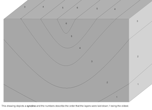
A syncline is a fold that bends downward. The rocks curve down to a center (Figure 7.10).

In a syncline, the youngest rocks are at the center and the oldest at the outsides (Figure 7.11).


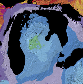
When rocks bend downward in a circular structure, that structure is called a basin. If the rocks are exposed, the youngest rocks will be at the center. Basins can be enormous. For example, the Michigan Basin is centered on the state of Michigan, but extends into four other states and a Canadian province (Figure 7.12).
Folds are sometimes, but not always the cause of geographic features such as hills or valleys.
Geologic processes that work at the surface, like erosion, are important in creating geographic features as well.
Faults
[edit | edit source]A rock under enough stress will fracture, or break. When there is a block of rock still standing on either side of a fracture line, as shown in Figure 7.13, the fracture is called a joint. One example of how joints form is when confining stress is removed from an underlying granite.

If the blocks of rock on one or both sides of a fracture move, the fracture is called a fault (Figure 7.14). Earthquakes happen when there are sudden motions along faults. When rocks break and move suddenly, the energy released causes an earthquake. Faults may occur at the Earth's surface or deeper in the crust. Faults are found alone or in clusters, creating a fault zone.

Slip is the distance rocks move along a fault. Slip is said to be relative, because there is usually no way to know whether both sides moved or only one. The only thing we can say for sure, is that one block of rock moved passed the other. Faults lie at an angle to the horizontal surface of the Earth. That angle is called the fault's dip. The dip defines which of two basic types a fault is. If the fault's dip is inclined relative to the horizontal, the fault is a dip-slip fault. Slip can be up or down the fault plane.
In the following images, you are looking at the fault straight on, as if you are standing on a road and the fault is exposed in the road cut. The hanging wall is the rock that overlies the fault, while the footwall is beneath the fault. You can remember which part is the hanging wall and which is the footwall by imagining you are walking along a fault. The hanging wall is above you and the footwall is where your feet would be. Miners often extract mineral resources along faults. They used to hang their lanterns above their heads. That is why these layers were called the hanging wall.
In normal faults, the hanging wall drops down relative to the footwall. Normal faults are caused by tensional stress that pulls the crust apart, causing the hanging wall to slide down relative to the footwall. When compression squeezes the crust into a smaller space, the hanging wall pushes up relative to the footwall. This creates a reverse fault (Figure 7.15).

A type of reverse fault is called a thrust fault. At a thrust fault, the fault plane angle is nearly horizontal and rocks can slip many miles along thrust faults (Figure 7.16).

Normal faults can be huge. They can be responsible for uplifting mountain ranges in regions experiencing tensional stress (Figure 7.17).

Strike-Slip
[edit | edit source]A strike-slip fault is a dip-slip fault where the dip of the fault plane is vertical. Strike-slip faults result from shear stresses. If you stand with one foot on one side and one foot on the other side of a strike-slip fault, the block on one side will be moving toward you and the block on the other side will be moving away from you. If the block moving toward you is the block that your right foot is on, the fault is known as a right-lateral strike-slip fault. If the block moving toward you is the one your left foot is on, the fault is a left-lateral strike-slip fault (Figure 7.18).

The world's most famous strike-slip fault is the San Andreas Fault in California, which is a right-lateral strike slip fault (Figure 7.19). Because the San Andreas is a plate boundary, it is also called a transform fault. People sometimes say that California will fall into the ocean someday, but this is a joke. The portion west of the San Andreas Fault is moving northeastward and someday Los Angeles will be a suburb of San Francisco, but the land west of the San Andreas Fault is a solid piece of continental crust that will not disappear entirely.

A fault may have broken and moved only once, but most faults are active repeatedly. There are two reasons for this. One is that plate tectonic processes continue in the same locations. The other is that a fault is a zone of weakness in the crust, and it is easier for movement to take place along an existing fault than for a new fault to be created in solid crust.
Stress and Mountain Building
[edit | edit source]
Mountains can stand alone or in ranges that formed at a similar time and in a similar way. Many processes can create mountains. Although most mountains form along plate boundaries, some result from intraplate activity. For example, volcanoes build upwards at hotspots within the Pacific Plate.
Most of the world's largest mountains result from compression at convergent plate boundaries. The largest mountains arise when two continental plates smash together. Continental lithosphere is too buoyant to get pushed down into the mantle or subduct, so when the plates smash together, the crust crumples upwards, causing uplift. The stresses cause folds, reverse faults, and thrust faults, all of which allow the crust to grow thicker and rise upwards.
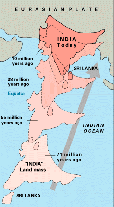
The world's highest mountain range, the Himalayas, is growing from the collision between the Indian and the Eurasian plates. About 80 million years ago, the Indian plate was separated from the Eurasian plate by an ocean (Figure 7.20). As the Indian plate moved northward, a subduction zone formed beneath Eurasia. The seafloor was subducted and caused the formation of a set of continental arc volcanoes. When the oceanic lithosphere was completely subducted, about 40 million years ago, the Indian plate began to collide with the Eurasian plate. Some of the Indian plate was thrust beneath Asia and some of Asia was thrust onto India. Rock also folded, which thickened the crust and formed the mountains. In places, the old seafloor that was between the two slabs of continental crust have been thrust over the Asian continent and are found high in the Himalayas (Figure 7.21).

Subduction of oceanic lithosphere at convergent plate boundaries also builds mountain ranges. The Andes Mountains are a chain of continental arc volcanoes that build up as the Nazca plate subducts beneath the South American plate (Figure 7.22).


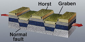
Rifting at a divergent plate boundary can also build mountain ranges. When crust is pulled apart, it occupies more area. The crust breaks into blocks that slide up and down along the normal faults that separate them. The result is alternating mountain ranges and valleys, known as a basin-and-range (Figure 7.23). The state of Nevada is the center of a classic basin and range province (Figure 7.24).

Lesson Summary
[edit | edit source]- Stress is the force applied to a rock, which may cause deformation. The three main types of stress go along with the three types of plate boundaries: compression is common at convergent boundaries, tension at divergent boundaries, and shear at transform boundaries.
- Where rocks deform plastically, they tend to fold. Brittle deformation brings about fractures and faults. The two main types of faults are dip-slip and strike-slip.
- In dip-slip faults, the angle of the fault plane is inclined to the horizontal, in strike-slip faults the fault plane is perpendicular to the horizontal.
- The world's largest mountains grow at convergent plate boundaries, primarily by thrust faulting and folding.
Review Questions
[edit | edit source]- Why don't rocks deform under confining stress?
- What type of stress is compression and at what type of plate boundary is this found?
- What type of stress is tension and at what type of plate boundary is it found?
- What type of stress is shear and at what type of plate boundary is it found?
- What is the difference between plastic and elastic strain?
- Under what conditions is a rock more likely to deform plastically than to break?
- You are a geologist walking around in the field when you spot a monocline. You inspect the fossils in each layer of the rock and you discover that the oldest rocks are at the top and the youngest at the bottom. How do you explain how the rocks came to be this way?
- Describe an anticline and name the age order of rocks.
- Describe a syncline and name the age order of rocks.
- What is the difference between a dome and a basin and what is the age order of rocks in each?
- Name one similarity and one difference between a fracture and a fault.
- What are the two types of dip-slip faults and how are they different from each other?
- California is plagued by earthquakes along the San Andreas Fault zone. Why are there so many earthquakes and why are they so severe?
- Volcanoes are mountains that form in two ways. Describe these two ways and how they are associated with a plate boundary.
- Describe the plate tectonics processes and associated stresses that have led to the formation of the Himalayas, the world’s largest mountain range.
Vocabulary
[edit | edit source]- anticline
- A fold that arches upward, in which the older rocks are in the center and the younger rocks are at the outside.
- basin
- A block of rock that has slipped downward between two normal faults.
- compression
- Stresses that push toward each other. This causes a decrease in the space a rock takes up.
- confining stress
- The stress due to the weight of material above a buried object. Confining stress reduces volume but causes no deformation.
- deformation
- The change of shape that a rock undergoes when it has been altered by stresses. Also called strain.
- dip-slip fault
- A fault in which the dip of the fault plane is inclined relative to the horizontal.
- dome
- A circular anticline. A dome has the oldest rocks in the center and the youngest on the outside.
- elastic strain
- Strain that alters the shape of a rock but that is not permanent. The rock goes back to its original shape when the stress is removed.
- fault zone
- A network of related faults.
- fold
- A bend in a set of rocks caused by compression. Folds are easiest to see in sedimentary or volcanic rocks that were deposited horizontally.
- footwall
- The block of rock that is beneath a dip-slip fault.
- joint
- A break in rock caused by stresses along which there is no movement.
- monocline
- A bend in a set of rocks that causes them to be inclined relative to the horizontal.
- normal fault
- A dip-slip fault in which the hanging wall drops down relative to the footwall.
- plastic strain
- Strain that causes deformation in which the rock deforms but does not return to its original shape when the strain is removed.
- reverse fault
- A dip-slip fault in which the hanging wall pushes up relative to the footwall.
- shear
- Stresses that pushed past each other in opposite directions.
- slip
- The distance rocks move along a fault.
- strain
- Deformation in a rock that is due to a stress that exceeds the rock's internal strength.
- stress
- Force per unit area in a rock.
- strike-slip fault
- A fault in which the dip of the fault plane is vertical.
- syncline
- A fold in rocks that bends downward, in which the youngest rocks are at the center.
- tension
- Stresses that pull material in opposite directions so that it is pulled apart.
- thrust fault
- A reverse fault in which the dip of the fault plane is nearly horizontal.
- uplift
- The upward rise of rock material.
Points to Consider
[edit | edit source]- Think about stresses in the ocean basins. Where in the ocean basis do you think you would find the features that indicate tensional stresses? Where would you find the features that indicate compressional stresses?
- Earthquakes are primarily the result of plate tectonic motions. List the three types of plate boundaries and what you think the stresses are that would cause earthquakes there.
- Which type of plate boundary do you think has the most dangerous earthquakes? How do earthquakes cause the greatest damage?
