User:Vuara/Ancient America Mystery
- http://www.viewzone.com/music.graph.gif
- http://www.viewzone.com/picket.styles.jpg
- At Canyon de Chelly, Edward Craig, Navajo, reproduces the signs and symbols from the walls of the canyon as remembrances.
http://www.viewzone.com/d1bar.jpg
Wednesday, June 3, 1998- Well, the ViewZone road crew has finally arrived in Kayenta, Arizona, where we're unpacking our equipment and getting in touch with our contacts. We've decided to take the rest of the day to get our land legs back.
Chinle, Arizona
The four corners area is one of the places where true American history really begins. The western states of Utah, Colorado, New Mexico and Arizona meet at right angles in the arid, red soil that permeates this scenic and majestic landscape. It is here, hundreds of years before Columbus reached the "new world," that the ancient people known as the Anasazi settled.
Now home of the Dine, called by outsiders Navajo, the area abounds with eroded landscape that has left towering mesas and striated cliffs of red, white, green and black rock. Each colorful layer has been revealed by the powerful force of water that emptied the once enormous lake that occupied most of the central part of North America. As the continent shifted, this huge body of water spilled southward with speed and abrasive power over the landscape on route to the ocean. Some spots resisted this sudden erosion and remain today as towering monuments to the past.
The deepest colors are dark, from when the earth was lifeless. Further up there are white layers which reflect the debris of shells and limestone from an ocean that once covered the land. As you look higher, the color turns to a distinctive reddish brown. This is the result of iron oxide - rust - and marks the era when the oceans were teaming with plant life and the planet was beginning to develop an atmosphere rich in oxygen.
Much of the four corners area is quite high in altitude. Vegetation is sparse but very diverse and hardy. Plants have evolved to conserve water and to cope with the higher levels of ultraviolet light that penetrate the thin atmosphere - one mile above sea level. The humans that occupied this area were forced to rely upon each other and quickly learned the benefits of agricultural planting and storing grain.
Monument Valley, Sixth Wonder of the Modern World, homeland to the Navajo, and a destination for tourists from around the globe. Poised on the Utah and Arizona border, Monument Valley has inspired writers and cinematographers and is a popular motif of the West.
Today, the Native Americans that dwell here, as well as their predecessors, place great emphasis on the cycle of the seasons and the importance and vitality of water. The religion and culture of these indigenous people is intimately linked with the earth and nature and is characterized by beliefs in myriad spirits and signs. It is a religion of the earth for the people of the earth and it has endured for much longer than our history is able to record.
Around 900 A.D., the Anasazi, main cultural ancestors of the Pueblo communities, came into prominence in the Four Corners Region. Nomadic hunters and foragers, who may have ventured in from the Mojavi Desert, the Anasazi settled in this area, creating large communities in Kayenta and Canyon de Chelly, Arizona, as well as Mesa Verde in Colorado, and New Mexico's Chaco Canyon.
A panoramic view of Canyon de Chelly (pronounced "shay").
Canyon de Chelly is shaped somewhat like a bird's foot, with three narrow canyons meeting at the town of Chinle. The high, arid landscape drops 600 feet to reveal a moderated climate rich in vegetation and water. Originally home to the ancient Anasazi, the Navajo now make their homes and plant their crops in this ancient canyon.
The Anasazi settled in- raising corn, creating pottery and building large, functional communities. They lived partly underground at first, but then began to build above-ground storage for their harvests. These structures, created from a mud-covered latticework frame, proved to be so functional and comfortable that the Anasazi started living in them.
As their communities grew, the building skills of the people grew with them. The Anasazi builders achieved an incredible degree of architectural mastery. Within and alongside the cliffs of the canyons they created multi-apartment complexes, many multi-storied.
They Anasazi prospered here until just around 1150, it is believed, when severe drought may have driven them to migrate to other areas. Shortly after that time, the Navajo took up residence in this part of the land.
In our next exploration we'll take you Tsegi Canyon and Mystery Valley for a close-up look at some of these dwellings and the petroglyphs and pictographs left by their ancient inhabitants. Don't miss it!
The focus of our trip to the southwest is rocks, and more specifically, the markings left on them by ancient peoples. Our final desination is southeastern Colorado, where we have been invited to look at inscriptions which may have been written in an extinct language, known to be the tongue of Indo-Europeans many thousands of years before Christopher Columbus made his discovery of the new world.
In our travels, we will stop at various sites known to be inhabited by the ancient indian tribes of Four Corners and examine some of the structures and symbols left behind by them. We'll also talk with some members of the Navajo and Hopi tribes who have lived in this area for centuries.
A Brief History
In order to shed light on some of the fragments and markings on this trip, we offer a very brief background on the inhabitants of the area.
Several hundred years B.C., native cultures in the southwest were comprised of three groups: the Mongollon, the Hohokam and the Anasazi (the name given by the Navajo who now inhabit the land). The Mongollon are usually credited with the introduction of farming and the cultivation of corn, squash, potatoes, beans, tomatoes and strawberries. They were the innovators of the circular pit houses, or kiva, that eventually characterized all of the Desert Tradition indians.
The Mongollon pottery started as plain red and brown, then progressed into red on white and black on white designs bearing stylized figures of people and animals. This pottery style, like much of their culture, was absorbed, along with Hohokam contributions, into the flourishing Anasazi nation.
The Hohokam people were expert artisans. They were also great engineers, creating canals and irrigating much of what is now the Phoenix, Arizona area. Their pottery was also embellished and they created many clay figurines that showed heavily influenced Mexican styles and designs.
The Anasazi ruins show that they lived in a tight community, in what appear to have been apartments. There were several underground circular chambers, or kiva, and archaeological data shows that they cultivated cotton and made fabric. One outstanding characteristic of the Anasazi people was their ability to live peacefully with their surrounding tribes and to assimilate unique skills and survival techniques into their own culture.
Mystery Valley
Our guide is Bill Crawley, a good friend who runs a tour service in the area. Bill's own interest ancient markings was excuse enough for him to take time from his busy schedule and show us some of his favorite spots.
Upon entering Mystery Valley (so named by early government surveyors because of the many markings found there) we could immediately see the need for 4-wheel drive and an expert navigator, since steep, narrow creeks are used for roadways. The area is sparsely vegetated, mostly sagebrush punctuated by occasional Juniper and "gum plant" (shown at left).
Much of the stone and mud construction still remains intact and the cliff dwellings remain as they were left when the area was abandoned. Around the dwellings we found pieces of colored pottery representing the various styles we described earlier. Inside, the walls of the shelter were covered with black coatings from the fires that had been used to warm the inhabitants.
Our exploration included three sites. Or first stop was Honeymoon Bridge, an arc shaped rock formation with a dwelling inside. We found both petroglyphs (symbols chipped into stone) and pictographs (symbols painted with gum and plant pigment) in this area. Or next stop, Manyhands Pueblo, was named for the many handprints left on the rocks here. Our last stop was at Lookout Cliff Dwelling, high in a cavelike structure from which inhabitants had a clear view of enemies coming down the canyon.
We were able to get some good shots of both the dwellings and the markings before we wrapped up for the day, which can be found on the following page.
The Barringer Meteor Crater- A short side trip.
While we're here in Arizona, we thought we'd stop by and show you the famous Barringer Meteor Crater. It's a giant hole in the middle of the Arizona desert.
This crater measures 4,000 feet across, 560 feet in depth, and has a 2.4 mile perimeter. It was caused 50,000 years ago when a huge, iron-nickel meteorite, traveling at 40,000 miles per hour, struck the rock plain of Northern Arizona.
Believe it or not, this crater is privately owned. It was purchased by a man named Barringer who spent over 27 years attempting to find the giant rock beneath. The venture cost Barringer and his associates over $600,000 ($10 million in today's money), but Barringer never realized his dream of a mining bonanza. He did, however, suceed in convincing the scientific community that the giant hole was caused by impact .
Since the terrain of the crater closely resembles that of the moon, NASA designated it as one of the official training sites for the Apollo Astronauts.Today the area is alive with tourist center, gift shop, RV Park and guided tours of the giant hole. The Visitor Center includes the Astronaut Hall of Fame and an Astronaut Memorial is also located at the site.
After driving for miles and miles on this incredibly long road, we've arrived in Kykotsmovi, Arizona, in the land of the Hopi. We're at the Hopi Cultural Preservation Center and are preparing to meet our contacts before we set up our equipment.
We noticed upon entering the Hopi reservation that numerous signs are posted prohibiting photography of any kind, as well as video and audio taping, or even sketching!
During our initial contacts to set up meetings we learned that these people are very private, and we are very respectful of that. We hope to be able to discuss current issues and concerns that face the Hopi today.
Our cameras are packed away unless, of course, we are given permission to use them.
Note: Out of respect for the request not to draw or photograph items that we see, the graphic designs on the following pages are created to give the feel of Pueblo designs in general, and are not meant to be interpreted as original Hopi art.
Hidden away in the canyon- Solar alignments and storyboards of the past.
We arise early from a very comfortable stay at The Cultural Visitor's Center, located right on the main road. We have received instructions to meet our guide for this morning's trip, Clyde Qotswiswma, immediately after breakfast. Clyde is an employee of the Hopi Cultural Preservation Office and a Hopi village clan member. During our drive we ask Clyde about his work.
Clyde's responsibilities center around the retrieval of stolen artifacts. He contacts museums around the world that have been found to hold sacred Hopi religious items and expedites their return to the tribe. Despite recent Federal laws to back him up, he encounters frustrating delays and unforeseen problems. He tells us of a sacred mask recently identified in one of the most important national museums. Prior to its return to the Hopi, it was found to have been impregnated with arsenic, a once common museum trick to reduce the destructive growth of molds and fungus on organic material. It has since been determined that there is no safe way to remove the poison so that the mask can be handled or worn again. Since the Hopi believe that these masks embody the very spirit in whose honor they were created, this situation presents quite a dilemma.
Clyde pulls our 4-wheel drive vehicle off the main road to a horseshoe-shaped canyon. Even in this remote and secret location, he is careful to wear his official identification badge and reminds us that we may be watched by the Tribal Police, who are more aggressive now in response to invasions of their land by outsiders.
As we enter the canyon, we notice that cliffs, some sixty feet high in places, protect a large flat courtyard and that the central plaza is graced by a high sun clock.
Centrally located, but invisible until it's pointed out, the clock is made from an existing protrusion of rock which creates a natural pointer at its right top corner. Recessed behind this rock stands a flat surface bearing a circular target-like petroglyph (shown slightly enhanced). Clyde tells us that during a certain ceremonial dance which is performed at the same time each year, the shadow of the pointer falls exactly in the center of the circles. According to Clyde, this date is the only occasion on which this natural phenomenon occurs.
We find this interesting since we have been told that some of the petroglyphs at our Colorado destination also bear this special feature.
We come face to face with the past in Sun Park.
Barely visible, many symbols and ideas have been pecked into the rock cliffs.
To the right of the sun clock we see several groups of petroglyphs that appear to tell a story. Images of people, more spirals, stars, and some animals are pecked into the rock. The graphics are stylized- the bodies drawn trapezoidal or triangular, suggesting a large upper body with narrow hips and legs. (We saw this in Mystery Valley, also.). The horned beings, taken by many to be a shaman, are always present. Clyde says that some isolated images are clan marks.
To the right is "kokopelei" the flute player, a repeating motif in the Four Corners Area. The bird is thought to be a clan symbol. Spirals and waves (left) - tales of migrations? To the left of the sun clock are the remains of more old petroglyphs. The dark patina of age is slowly being eroded away from the bottom by the weather and time, but enough of the panel remains to see the many examples of the ancient artisans.
We spot some graffiti from more recent visitors and perhaps even from modern Hopi, but these markings are easily distinguished from the darkened, pecked grooves of the older messages. The old work appears to be grouped in specific and confined spaces within the park, as if they might be put in that spot for a specific reason. Why? Clyde offers no explanation or translation for the ancient murals, but allows us to walk among the stones and respectfully photograph the work.
Some of the past is gone forever in this deteriorating and weathered storyboard.
"We think that the spiral represents the number of years or cycles," Clyde finally offers, "and the wavy lines that often come out from the spirals may represent a migration. The height of the waves may represent the degree of difficulty encountered on the migration."
What story are these walls trying to tell? If someone still maintains the knowledge of translating them, will this skill soon vanish with the rest of the Hopi culture? In a moment of stark awareness, we face the reality of Hopi future. For a few awkward moments there is silence in Sun Park. We are not sure what Clyde feels. Is it hope for the future, or perhaps resignation that the ways of the past are weathering away with time? Before we can ask, Clyde motions us to return to the truck for the next destination- Awatovi, the oldest continuously inhabited village in North America.
Driving from Sun Park to the ancient village of Awatovi took us over the stretch of Highway 264 that was being resurfaced. Modern equipment with conveyor belts accepted amalgum from waiting trucks. The newly paved road was smooth and quiet, but we were thinking about Clyde's story of the bulldozed shrines. Were we riding over them right now?
The drive to Awatovi was a long and hot one. Clyde drove the four-wheel up a dirt trail, over a steep sandy incline and parked on the ridge of a spectacular mesa that looked southeast, toward the San Francisco Mountains in New Mexico. Between the mountains and the mesa, the vast expanse of rolling, fertile plains looked like the ideal place to raise sheep, grow corn, hunt buffalo and build a community.
The wind was blowing strong and the dry air was little comfort against the sun as we walked amidst rubble on the high ridge. Here, in excess of 6,500 feet, the air was thin. We could actually see the horizon curve with the earth before us. The ruins were everywhere, as far as the eye could see, atop the mesa and spilling down to the valley. Awatovi was not just a village, but a metropolis of multi-level dwellings, kivas, storage areas and plazas. With little rain and the baking of the sun, mud and stone still remained firmly intact in a few locations. We could see walls and the square foundations of the now buried pueblos.
Clyde told us of some of the old and recent history of this village. It was settled back in 1100 A.D. While standing in the hot sun it was easy to forget that these areas get their share of snowfall and freezing temperatures. This location, although ideal for watching over your sheep or spotting invaders, was not an ideal winter residence.
Awatovi's decline was punctuated by disputes with other clans, but it actually appears to have been simply abandoned. Many broken pots and sand filled peublos still hold on against the weathering of time.
Since the wind was strong and sand blew in our eyes, we were persuaded to leave this place to its solitude. We returned to Clyde's truck and headed back to Kqotsmovi.
We were invited to visit the Hopi Museum and spent some time viewing the exhibits and a large collection of the Edward Curtis photographs. In these photos, taken around the turn of the century, the highly artistic style of the Hopi people is illustrated in their dress and hairstyles. Along with the photos we enjoyed the display of baskets, pottery, silver jewelry and masks.
Out of respect, we did not attempt to take any unauthorized photographs during our visit.
The ViewZone crew wishes to thank Leigh Jenkins Kuwanwitswma and Clyde Qotswisiwma of the Hopi Cultural Preservation Office for their cooperation in sharing this special view of Hopi life with our readers. As we metioned previously, your help in securing computer equipment for their great task in urgently needed.
We're headed for our final destination- La Junta, Colorado. Before we begin inspecting the inscriptions at this location, there is another type of Indian petroglyph that you should be familiar with- that of the Plains Indians.
The Four Corners Expedition was initiated by our invitation to visit an area in southeast Colorado, where a group of scientists have discovered evidence of a foreign civilization who used an alphabet similar to an extinct language last seen around 500 B.C. in Arabia. Obviously this does not fare well for believers in Christopher Columbus or Leaf Erikson and their claim to "discovering" America.
In fact, the continent of North America was likely discovered by the ancestors of todays Native Americans, who migrated here from Asia. We see tantilizing evidence that these indiginous people were visited by sea-farers from both the East and West, and that a variety of cultural traits from these areas were incorporated into the Native American culture. Most of the evidence for this has been speculative and centered around a few small artifacts and a great deal of imagination. The Colorado discovery is different.
In preparation for this discovery, we have taken you to see many of the outstanding petroglyphs made by Native Americans in the Southwest. We have seen small figures of birds and goats with horns repeatedly pecked into the weather walls of canyons, and these have been attributed to clan markings (see bird petroglyph below). We have also seen various sun symbols and stylized human and animal forms carved into the blackened rock faces of the Hopi Sunpark. Some of these were clan marks as well, but others appear to be stories that used symbols and shapes that were well understood by their creators.
In his book, The Rocks Begin To Speak, which we will mention later in detail, LaVan Martineau has successfully translated the meaning of these various shapes and figures. His crowning success was the translation of the Kit Carson campaign, as recorded in petroglyph form, which appeared earlier in our expedition. Martineau has also discovered that the Hopi used these same universal symbols to detail their snake dance, a ritual usually performed in the late autumn to solicit rain for the maturing corn.
We Quote from Martineau's book:
"Symbol a is a deity reaching out of his dwelling and saving the crops. The V-shaped symbol opening exists where the head should be. The arc formed by symbol b is a covering of this opening in the neck of the deity. This is the sipapu - the spirit entrance to the underworld, which the to the Hopi is heaven and the abode of some deities.
The sipapu is very common in Hopi ceremonies, and is still used in the Snake Dance, where it is represented by a hole dug in the dance arena and covered with a sounding board. The dancers stomp on this board each time they circle the arena with a different snake.
Symbols a and b clearly indocate the sipapu. Symbol a is the spirit coming out, indicated by its body and arm protruding outside the covering, as if in the act of emerging.
Symbol c is a man stomping on the sounding board over the sipapu, and symbol d represents the circuit made around the arena with each snake before it is freed (e).
Symbol f is an accompanying dancer who makes the circuit each time to help guide the one holding the snake..."
The explanation goes on is great detail but we suggest you read this for yourself.
I would recommend Martineau's book, The Rocks Begin To Speak (Library of Congress 72-85137) and an additional book, Ancient American Inscriptions: Plow Marks or History? by William R. McGlone et al. (ISBN 0-10953-65-xxx). The latter will be available on this web site shorty.
In general, the Plains Indian petroglyphs and pictographs appear ro have been drawn in pictoral symbols, or representational form. As most of the Native American languages were not written, these symbols seem to act more as reminders to the story tellers who would embellish the story with important, memorized details and lessons. Symbols also appear in combined form to make compound meanings.
In one early pictograph at Mystery Valley, we saw the symbol for "war" (two arrows pointing at each other), combined with a circle, "holding" and gave a possible explanation of the phrase "holding war" as a meaning. To the right, the horizontal line or "trail" symbol is combined with the pictograph for "temple" or "gathering place", possibly meaning that the inhabitants had moved to the populated area.
The Plains Indian art we will be encountering in Colorado will be similar. It will contain numerous clues as to the recent origin of these markings, such as the depiction of horses (brought by the Spanish in the 1600's) and of White Men (usually depicted with cowboy style hats) and rifles. We mention this because these petroglyphs were often drawn on the same stone walls as the much earlier abstract art and, most importantly, the alphabetical writing that we will be examining. Some prime examples of Plains Indian petroglyphs are shown below. Note that they seem to be inscribed or scratched into the rock rather than pecked, as many of the older glyphs are made.
+++
Help Solve The Mystery of Ancient America's Canyon People
An amazing discovery in Southeast Colorado suggests that ancient America could have been visited by a culture with roots in Asia. Rock carvings and other evidence are presented here for public scrutiny the first time. Your comments and discussion are welcome.
The land around Southeast Colorado is arid, supporting cactus and tall grass. It is used today for cattle grazing and is sparsely populated. In the past, this area was known as "the Sea of Grass" because, prior to the introduction of the horse by the Spanish, the Native people had great difficulty navigating the hills and valleys that were covered with tall, thick grass. That same grass is kept short now by thousands of cattle that graze the area.
The Native people were able to navigate the many canyons and rivers in this area, as is evidenced by their artifacts and carvings found here, but the area was, and still is, largely unexplored and uninhabited. The isolation of this area has preserved a unique and mysterious collection of rock writing -- called petroglyphs -- that can be found mingled with the familiar scrapings and art of the Plains Indians. Not many know it exists and still fewer are able to understand the significance of what appears to be an ancient system of writing.
Viewzone Magazine was asked to investigate this phenomenon and to publicize the data on the internet. It is hoped that some scholars of archaic languages might be able to shed some light on the origins of these odd symbols. And so, in the summer of 1998, Viewzone took a team to Colorado and photographed the petroglyphs with a high-resolution digital camera. Some of these images are presented here.
We initially planned to visit only this one archaeological site in Colorado. To gain some quick education in American rock art we headed to one of the oldest inhabited areas of the Southwest, where the great and mysterious Anasazi ("ancient competitor"). See beginning of this expedition for our exploration of both the Hopi and Anasazi ruins.
Here's what we learned from the "Four Corners" area: We noticed that Arizona's petroglyphs were sparse and isolated, almost hidden. Most always they were small animals with horns - goats or sheep - and were interpreted as Anasazi clan marks. In fact, we saw more pictographs, or painted images, on the ancient dwelling walls than we saw petroglyphs. The interpretation of the other symbols is pretty well understood and is believed to have been a sort of "universal" inter-tribal language based on hand signs. At least this is the highly regarded effort of LaVan Martineau. Martineau was adopted by a Native American family as a youth, exposed to the science of cryptography in the military, and he applied his unique talents to decipher the signs and symbols of the "universal" Indian language as it appeared on the rocks throughout America. His translations have opened up a view of Native American history from a perspective uncommon to most white history books.
"Holding war... gone to the main city..." - An attempt at a translation using Martineau's technique.
Most Native People's language was not written, only spoken. When two tribes with different dialects met, they often communicated with hand signs, and this practice is still sometimes used today. Martineau's ability to recognize graphic representations of these hand movements allowed him to inspire historians and archaeologists all over the West. We would strongly recommend his book, The Rocks Begin To Speak (Library of Congress Number 72-85137).
We revisited the symbols in Mystery Canyon (above) and noted that Martineau's translation would have had the two arrowheads interpreted as "conflict" or "war" while the circle would mean "holding" - "holding war?" Was this the last painted message left by the Anasazi before they disappeared into the shadows of history? In some of their most remote habitats there was still grain and remnants of basketry, left abruptly. To the right is a stepped figure that begins with a horizontal line. The line looks like "trail" while Martineau seems to suggest the steps mean "temple or heaped-up place" - some important place (note the similarity to the faded symbol in the Hopi Sun Park). Perhaps this was a message that they were leaving to assemble at some obvious center before going to war? Or had war forced them to travel to a more fortified area? We're just guessing. But that's the way it works when you have no writing and mere symbols.
+++
The Mystery of Ancient America's Canyon People
To attract their prey, Plains Indians believed that the "heart-line," seen in their petroglyphs as a line which usually enters the mouth, allowed them to "call" the animal's spirit, drawing it close for easier hunting. This heart line (in the buffalo above) was often, but not always, connected to a hunter. In some similar petroglyphs, the animal is depicted with "phi" like symbols in its back - a successful hunt?
Some of the petroglyphs in Southeast Colorado were different from anything we had seen in either Arizona or in Martineau's book. Only a few of the stick figures, with circles as heads, seemed familiar. It was writing but in what form? There were what appeared to be organized groups of symbols, about twenty six different ones in all, that were repeated on hundreds of rocks along the canyons of the Pergatory River. Most of the "writing" was within a narrow region of land that stretches from the Arkansas River to the Oklahoma panhandle, near the Cimmeron River.
Bill McGlone has spent a good part of his life photographing petroglyphs and has extensively documented the mysterious writing in Colorado.
Viewzone was hosted by Bill McGlone, a highly intelligent man who has been the hub of what little research has been done in this area. Bill moved to La Junta, Colorado soon after he retired. Being an engineer, his mind was always active and curious about his surroundings. All his life, Bill had been learning the local history and visiting the locations of decisive battles and event-- in whatever region of the world his occupation took him. Originally from Indiana, Bill was drawn to this beautiful and friendly town by something he had seen while visiting the area - a very real mystery - and one that he would pursue for the rest of his lefe.
Before we really let you have the details we must warn you. First, don't put down your copy of The Rocks Begin To Speak, because you will see lots of Plains Indian style petroglyphs and pictographs. The Native Americans used many of the same walls to petition the Great Spirit or to record their own events and ideas. These petroglyphs often are carved over a darkly patinated and much older collection of repeating letters. We also ask you to keep an open mind about what you see. There is very little known about this phenomenon and, in a very real sense, you are part of our expedition. You share in the mystery and the solution to this historic riddle.
The Sites
The archaeological region we visited is deceptively blank (white space) on most maps of Colorado. In fact there are little signs of civilization in this dusty area. It's the "wide open space" where the buffalo once roamed. The area is a patchwork of barbed wire fences and cattle troughs. The deep canyons in this ptherwise flat landscape seem to have been etched from the sandstone by what remains of the Pergatory River (or "Picket Wire" as it is called by locals). Just a few hundred years ago, this area was quite different. The grass was taller and ungrazed. Its 4 to 5 foot height rippled like water as the winds pushed across the rugged landscape. Historians call it the "Sea of Grass" because, like a sea, it was difficult to cross and remained isolated from the surrounding communities. Only when the Native Americans utilized the Spanish horses, in the 16th Century, did travel and hunting become worth the effort. But much earlier and deep inside the Sea of Grass there were people that could read and write.
Could the "Picket Wire" or Pergatory River Canyons have been the community of an ancient sea-faring culture?
The land is mostly owned by large ranchers. This makes viewing these special sites quite a privilege for Viewzone's crew. Bill McGlone respects the privacy of the ranchers and limits his intrusions to objective research and discourages any attempt to trespass by sight-seers. His cooperation was vital. We were also been invited to one of the few archaeological "digs" that is being conducted in this area. As you will see, this is a very special area.
We woke up early. The position of the sun effects the visibility of the petroglyphs. The alphabetical petroglyphs are pecked (as opposed to scraped or painted) on to the stone by some sharp tool. Experiments have shown that a sharp piece of flint, held in the hand, is excellent for this purpose. The rock typically has a black coating or patina which is the result of thousands of years of deposition. Bacteria and chemical reactions with magnesium and iron in the rock coat the surface like hard tar. The early "carvers" of these stones would have chipped away the patina to reveal the brightly colored rock below, some of which is almost white. The original petroglyphs would have been quite visible and would have had excellent contrast. Today, the passage of time has allowed the same chemical reactions to form a new patina over the carved surface and measuring this later patina is a good clue to the age that they were first made. The carved petroglyphs are as black inside as the rock surface from which they were carved. Laboratory analysis of this newer patina has been carried out on a few selected grooves of the Picket Wire Canyon petroglyphs. This placed possible ages for some of these petroglyphs to be from 2000 to 3000 years old. Some look much, much older.
When you first see them, your eyes focus on the more contrasted and relatively newer Plains Indian art. The themes of these carvings deal horses, shaman and other human shapes. Plains Indian art is often scraped, not pecked, into the stone. When lit from the side, artificially or by the angle of the sun, the faint depressions of the older, more shallow and blackened marks readily reveal themselves. Bill and his associate, Ted Barker, have visited every site at every time of day. And so it was a matter of the position of the sun that dictated our hurried schedule to various canyon walls in the early morning and late evening afternoon.
Look closely and you will see all four styles of petroglyphs on these rocks (pictured above and below). The meandering lines are examples of the abstract form, the tree-like figures are examples of the mysterious alphabet in compound form, the animals are likely Plains Indian marks and there are occasionally names and dates scratched into the collection.
Our first stop was just a few miles south of La Junta. The rocks were perfectly illuminated by the sun from the side. We clearly saw all four of the styles that both Bill and Ted had cataloged. There was the oldest abstract shapes and meandering lines and spirals. Then there was the mysterious alphabet, the Plains Indian renderings of animals and spirits, and finally the recent "cowboy art" and graffiti.
The graffiti and Plains Indian art was obvious. Its color and the depth of the grooves indicated it was much younger than the barely visible ancient marks. The intent was to create symbols or pictures that told a story. We couldn't understand them but, from Martineau's work, we were sure that they could be read. But they were symbols and pictures, not an alphabet. And their appearance on the rocks obscured the oldest layers of the black rock.
Some of the older petroglyphs were familiar to us. Goats heads with horns swept back, a deer-like animal with multiple antlers, and the ever present spiral and sun signs that we had seen in the Hopi Sun Park. Contrary to what we had been told in Chinle, this sign was frequently indicative of a solar alignment where a particular shadow would be cast on the spiral at a unique time of the year, usually at sunrise. Other spirals did not appear to have been intended for such alignments but were symbolic of the sun itself. These spirals seemed to be of the much older type of petroglyph, often blackened and faint like the ancient alphabet.
While Viewzone takes dozens of photographs, our local guides, Bill and Ted, assure us that "the best is yet to come."
Writing or coincidence? You can decide for yourself as we view some of the strongest evidence.
We have been given a rough map that has many unmarked roads that can be found only by looking for landmarks. Much of the land is devoted to cattle and we have frequent encounters with animals that are either lying down in the road or are startled by our vehicle and run in front of us. The map could be that of a small village but, in reality, it covers about 200 miles. We were instructed to stop at certain locations and "hunt" for the petroglyphs. Notations made by Bill, like "look on top of cliff," was our only clue.
Our first stop required that we climb down into a large flat canyon which is bordered by two parallel stone walls. The climb is difficult but the reward is well worth the effort. At the bottom we can see a large collections of symbols, arranged in a row. These symbols are pecked deep into the rock face and have some residual chalk from prior attempts to make them photograph better. This "enhancement" is unfortunate because it precludes any valid means to determine the age by contaminating the patina. This particular collection of symbols was perhaps the best example of what has been called "writing" and what, according to Bill McGlone, could very well be in the ancient alphabet called Thamudic.
"Bill had written to me, describing an enormous number of petroglyphs that he had been studying. Some of these rock carvings appeared to be much more than mere doodles in stone, or the graffiti of Native Americans. He saw writing, with letters and repeated symbols. Over the years, Bill had attempted to identify these letters and, shortly before his death, January 30th, 1999, he had made a reasonable argument that some of the petroglyphs were from an Arabic alphabet, called Thamudic, which would have been made by Turkish sailors around 500 BC. It was this claim that prompted Viewzone's 1998 Expedition, still posted in the magazine's archives."
Bill informed us that the famous writer, Barry Fell, examined these same petroglyphs in photographs and was the first to suggest that they were ancient writing. Unfortunately for Fell, the photographs were not detailed enough to discriminate between the petroglyphs and naturally formed rock stains. When Fell's attempt at a translation was reviewed at this site, this was abundantly clear - even to Fell. Although Fell was on the right track, his work was summarily discredited and the possibility of these symbols being "writing" was largely ignored by scholars.
Chalk is not used any more for enhancing these marks. Bill McGlone and his team once had success with aluminum powder which they painstakingly applied to the grooves and photographed. The aluminum was inert and could easily be washed from the petroglyphs after the photographs were taken. It should not have hindered any age determination techniques, however, the current opinion is to leave the walls untouched. Our digitally enhanced images are the best for recording these ancient messages. Some of the illustrations shown here were made with this aluminum enhancement and we are grateful to Bill for sharing these old photographs with us.
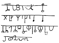
In addition to the horizontal arrangement of symbols, this same alphabetical system was used in what has been called the "music glyphs." A sixty foot horizontal line has been pecked into one canyon wall with vertical lines descending every couple of inches. At the base of each short vertical line there is a symbol, sometimes repeating and often different. Some of the symbols and shapes are presented (traced) on the right-->
The symbols appear to have been carved at different times, perhaps to mark the passing of time as with a calendar or to help with the telling of a long story. The truth is we do not know. We only know that a Thamudic alphabet can be seen in these "musical notes" and appear to be purposely and meticulously etched with great effort and over a long period of time.
Every square inch of these walls is covered with markings and carvings, many on top of older and faded ones. This would suggest that a community of substantial size and duration lived in the area and that this particular location was some type of community center. The large plaza and the supply of water from the Purgatory River would have made this an ideal location for a habitat.
Looking at the walls, we noticed that there were frequent spirals associated with some types of solar alignments. To test this theory we place the back of our head against the spiral and look towards the rising sun. The sun aligned with pointed rocks that protruded from the canyon wall. The shadow of this pointed rock passed through the center of the spiral as we watched the sun rise. We were only a few days shy of the summer solstice and we could easily see that this spiral would mark the longest day at sunrise. Solar alignments were found at virtually all of the petroglyph sites.
An accidental discovery begs for an explanation and adds another clue to the mystery.
Our map also directed us to look for a wall that contained "writing" that was atop a high mound of earth (< -- see photo). Being about 30 feet above the canyon floor, the mound was the only way to reach this wall. As we approached it, we could see what was perhaps the most prolific collection of petroglyphs confined to a small, 25 foot long and ten foot high portion of the wall. We were directed to look for a group of symbols at the top left of the wall. Although they did not appear to be related to the Thamudic writing they were certainly odd and worth photographing.
The Wall itself contained layer upon layer of petroglyphs, such that it was impossible to discern any shapes or symbols with the naked eye. It seemed as if the wall had been used for some purpose over an extremely long period of time and that petroglyphs were drawn over faded petroglyphs for centuries. The wall was so interesting that we took many shots of it - something that would prove to be a stroke of luck when we processed them on the computer later in the evening.
Because the rock face color is uniform, the minute pecks that make up the petroglyphs can only be seen as shadows, and even then, as faint shadows. With the help of manipulating the contrast and color balance, we were able to show many of these markings. The first thing we noted were the older, abstract style of meandering lines. However, in our enhanced versions, these lines were not meandering - they actually seemed to be forming shapes and outlines. As we traced the enhanced pictures we discovered that the wall was actually a large mural of an elk, with giant antlers.
The precision with which the hoofed feet and the proportions of the elk were drawn were very different from the stick figures of the Plains Indians. It also appeared that this mural was related to the odd symbols we had seen that did not appear to be Thamudic. Could we have discovered a yet older culture that inhabited this region?
We noted that the right antler was artistically extended to encompass the right half of the wall (not visible in photos above). Several slash marks appeared to have been made by repeatedly scarring a portion of the antler with a sharp object or objects. Again, these scars appeared to have been made over a long period and at different times, perhaps by different individuals. Could this have been a ritualistic image that hunters used to sharpen their spears before the hunt? Could the slashes be recordings of successful hunts? Again we could only guess.
We left the canyon with more questions than answers. Our map directed us to yet another location, some hundred miles away. We wondered what we would find there.
Unimagined shapes and symbols lurk in the faint backgrounds of these ancient stones.
We are pleased with our discovery of a huge elk image in the rock art. But we are curious about some of the fainter petroglyphs that are behind the elk. A close-up of the area above the elk's hind quarters reveals an odd collection of circles, often connected to other circles by pecked lines. We also can see what appear to be tree-like shapes with arms or branches that terminate in these circles. Also, near to the top of these images, we can see compound symbols (a collection of symbols grouped together in one design) that incorporate the circle as part of the "trunk" of the tree.
But we don't know that the Picket Wire people meant for these to be actual trees. Probably not. We have read that the elk was often a symbol for fertility in the Old World. Perhaps these circles can mean something like "life" or a "living thing" and then the tree concept can be viewed as the "family tree" and perhaps has significance in recording family lineage or births. This might also explain the "phi" symbols as meaning "death." What better symbol could signify the death of an animal than a slash through its symbol of life?
We also note that, paradoxically, the human hand, appearing repeatedly on this wall, is a symbol for "bloody hands" or "death" in Martineau's interpretations. We see many hands on the bottom but they are all very small - much smaller and more realistic than the stylized hand in the antlers (lower right of picture). It seems as if they have been traced from actual hands. We have been told that the dwellings and artifacts of in the area suggest that, like the Anasazi, the people of these times were small. But some hand prints are even small for a three to four foot human and are obviously those of children. Most all are left hands. Where the hands can be seen clearly, they are male. Anthropologists tell us that in men, the ring finger is longer than the index finger. While in women this is reversed.
Were the elk and the circles drawn in different eras? This is a question that will have to be answered on a return to this site with Polaroid's new PDC3000, a mega pixel camera that will allow us the resolution we need to extract this answer. In the meantime, we can only assume that the elk, whose hind quarters do not contain any circles, was incorporated into the mural with them. These pictures were taken with a 600 x 800 pixel camera.
To complicate matters, there appear to be yet older and more crudely drawn circles pecked into the surface. Visible only as a pattern of pits and specks, when connected, they begin to form some of the oldest of these rock symbols.
Lined up like a giant dam, huge boulders reveal the oldest secrets yet!
Our next map location takes us to what was once a natural reservoir, since fortified with a dam to control periodic flooding. Although many old sites could possibly be under water now, several very old rock cliffs surround the reservoir. These rocks are extremely black and show signs of cracking and breaking away from the face of the cliff.
Many compound symbols can be seen.
Are these symbols combinations of the Thamudic writing?
As we approach we notice that there are the familiar "phi" signs and many of the tree-like shapes that we saw mixed with the music glyphs and the elk wall. We wonder if these symbols formed words or if they told a story. Also, would each compound design be read alone, or in context with the adjacent symbols?
At this location there were many dot patterns. In LaVan Martineau's system of the universal language these would be interpreted as meaning rain or small particles. But these dots seemed to be different. They appeared to be arranged in neat rows and columns, as if perhaps keeping a tally of events. Some had from six to ten rows, with any number of dots in each row. It was not possible to determine if the dots were made at the same time, or added to over a long period. The surface was just too worn to guess. The thought occured that this might be measuring a life span, but we were reminded that it was rare for the ancestral humans to have lived beyond 35 or 40 - and many of the "tallys" had well over seventy dots in them. Perhaps these were not years, as we know them, but seasons or lunar cycles. Again, we can only guess.
While the elk wall had many circles on its tree-like compound symbols, this location had an abundance of semi-circular "branches." When they did have a shape attached to the branches it was frequently in the shape of a "Y." But this was only true to the naked eye.
When we later examined the digital images for a pattern of small pits, we were able to play a sort of "connect the dots" game. By doing this, many of the older shapes became visible. We noticed that the visible patterns appeared to us to be parts of much older and more intricate patterns that had been partially re-pecked. These older petroglyphs are covered by black patination from thousands of years of weathering. An example of these patterns can be seen in the animation below. This is just a partial outlining of what is hidden on this four foot wide area of an enormous boulder.
These older and heavily patinated petroglyphs show the same circular patterns and tree-like arrangements we had seen on the "elk" wall. We decide that we should look for these in each site that we have photographed. But that will have to wait. We are off to yet another destination and an encounter with the past. This time in the Oklahoma panhandle.
The Oklahoma Connection: Familiar shapes but something's missing.
For the next location we report to the Department of Forestry where we pick up a key that unlocks a gate to protected land on the Colorado and Oklahoma border. The site is located in the Comanche National Grasslands and access to the petroglyphs is restricted to research. Again, our host, Bill McGlone has made all the arrangements and our visit has been anticipated by the authorities.
We travel about a hundred miles on dusty unpaved roads and arrive at the gate in the heat of high noon. The landscape is familiar to us. We are presented with a large flat plaza, surrounded by tall sheer cliffs. A small stream meanders through the plaza and there is ample vegetation and signs of recent cattle grazing. This is another ideal habitat and a possible center for a clan or tribe.
We spot our first petroglyphs easily. Called "the arena" on Bill's map, the site consists of a scooped out cave that has a large collection of vertical slash marks. These marks are very similar to those on the elk wall that we saw and appear to have been made over a period of time, perhaps with different tools. This could very well be connected to the same people that made the elk wall petroglyphs.
We look closely for the pecked shape of elk antlers, as we found in the previous site, but there are none. The slashes appear to have been made on protruding horizontal section of the cave wall. There is little other art except for a few small quadrupeds that look like cattle in the Plains Indian style. Much of the interior of the cave is crumbling and breaking away from the cliff. If there was anything to offer a clue as to the intent of these rows of scars, it has long since turned into rubble.
We continue searching along the cliff walls and eventually come to a barbed wire fence that marks the Oklahoma border. Crawling under the fence we follow the map to a huge collection of boulders. There, among the rocks, we find a flat topped one with many smooth scoops on it. This is "metate rock," a place where the people of the past ground their corn and other grain into flour. These smooth depressions (metates) were made by years of scraping and mashing with a special stones called a manos (literally "hand"). There were many such depressions on this one rock and the signs of age were obvious.
Corn and seeds were ground to flour in these stone mortars. Rounded stones called a "manos" (inset in photograph) were used to mash the material in these worn depressions.
Who made these natural mortars? The clue was on the side of the same rock, facing the cliff. A beautiful collection of petroglyphs showed what looked like a family of elk arranged in a row, facing south. The elk were all different in size and character. A dominant male with large antlers took a superior position in the group. We recalled that our Plain Indian expert, LaVan Martineau, suggested that the elk were used to represent a family group, or clan. Could this be a symbolic family portrait? The idea was plausible. At the very least we had the coincidence of elk petroglyphs and vertical slash marks at the same site, but that only raised more questions. Were these the same people who had made the Thamudic-like signs -- or could they be an early Plains Indian culture that used the elk motif as part of their symbolism?
Curiously, we also found several examples of the circles that were also associated with the elk motif. Although some of the older petroglyphs showed the familiar tree-like arrangement, the most striking example of circles was in what was called the "small pox woman." Given the name by white explorers who assumed they understood the significance of this petroglyph, this three foot figure is just a few hundred yards from the metate rock.
Her hair style and slim body give little clues except that she is literally adorned with circles, many of which are interconnected with lines and other circles. If this is of Plains Indian origin, then the circle motif was familiar to them. In fact there was a rumor that this figure was used by the Plains Indians as a fertility site.
What we do not see in this location is evidence of the Thamudic writing or, in fact, any of the symbols that have been associated with it. This site appears to contain Plains Indian petroglyphs and perhaps some older culture that utilized the circle and elk motifs.
Our map has one remaining stop to visit. Will this next site solve some of these mysteries or just leave us with more questions? We are anxious to return to La Junta and to show Bill McGlone our findings. Perhaps he will be able to explain what we have seen.
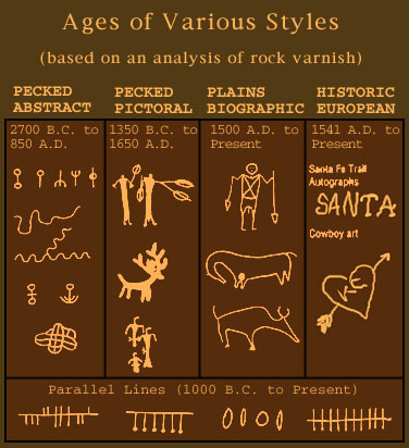
The rocks are dated. Surprise! Some of these petroglyphs are 4700 years old.
Dating the petroglyphs has been accomplished in the past by associating the styles and designs with similar designs found on pottery, whose dates are known. Another way of dating these carvings is to locate their use on formations in layers of the earth whose dates have been calculated by some other means. But these dating techniques are only circumstantial.
If someone from a particular time in history was to bury and object, or dig up a previously buried object, this object would mistakenly be associated with the level of earth in which it was found. These types of errors were unavoidable. But now a direct method has been used. Professor Ronald Dorn (right) of Arizona State University developed a reliable radiocarbon dating method by sampling the varnish in the grooves of the petroglyphs. This rock varnish or patina forms very slowly in the hot, arid Colorado climate. The original artists would have pecked away at the dark varnish to uncover fresh bright rock. As the varnish forms over this fresh rock, it captures organic matter which can be separated and dated.
Several samples were run through this test for each site. Examples of all of the various grouped styles were sampled and averages ages were obtained. The results are below. (Thanks to Bill McGlone for sharing this data. References and inquiries will be forwarded.)
The oldest and most perplexing are the abstract petroglyphs. They do not remind us of anything recognizable. Sometimes they do look as if they could have been the writing of some unknown alphabet, while other times their meandering and random shapes totally allude us. It's unthinkable that these were done randomly. They are painstakingly pecked out of the rock surface with some effort and time by the carvers and, often but not always, they seem to have a hint of patterns or similarities. Some of these showed very old dates of up to 4700 years ago! Similar petroglyphs in other parts of the world have been dated back to the Bronze Age. The elk that we were able to trace on our previous site seems to be of this oldest type. At least if you group it into the "abstract" family. But it is most certainly not abstract. It's too early to guess.
Since there are at least two very different styles in this group -- the meandering lines and the alphabetical shapes -- we will need to know which dates apply to which styles. The alphabetical symbols were dated at about the time of Christ, give or take a few hundred years. I'd prefer to see them in a different group because of the difference in time -- almost two thousand years difference -- but oddly they do appear related at some sites.
The pictorial style is the next oldest. These shapes are often solidly pecked and not merely outlined. The examples of quadrupeds with horns and antlers are in this group. The petroglyphs in both Mystery Valley and the Sun Park of the Hopi are also in this group. Occasionally we will see shapes that are similar to the alphabetical style (like the "phi" sign). It is argued that the alphabet, similar to Thamudic, was carved BEFORE the pictorial petroglyphs -- as much as a thousand years before. This view believes the people who made the pictorial style "discovered" the rock art from some previous inhabitants and then used some of these symbols in their own system of rock art. This view assumes that there were different cultures in this same area at different times.
But what if this was the same culture, evolving through thousands of years? We would now have to place the alphabet style AFTER the pictorial style because we would have the more organized alphabet system evolving from the earlier pictorial use of these same shapes. It would show intellectual evolution. But sadly, the dates show that the more organized alphabet was carved well before this use as symbols.
The biographic style is easily differentiated from the other styles in that it is made by scraping the shape in the rock and not by pecking. The scars in the rock are usually deep and enduring, often made right on top of the faded abstract and pictorial petroglyphs. Dating of these petroglyphs was easy and it appears that there is little controversy. Again, we sometimes see similarities in the symbols of the Plains Indian petroglyphs and the alphabetical and abstract meandering lines, but this case of copying what was "discovered" is obvious and historically proven.
The European style is very contemporary. Names and dates, hearts with arrows and often some famous people like Kit Carson are found in the area.
The parallel lines are somewhat of an enigma in that they appear unrelated to all styles and seem to be about 3000 years old. How do they fit in with the cultures of this region? Our next and last stop on the map would yield some surprising information and some even more explosive evidence.
Our last stop visits an archaeological "dig" and some exploration of our own. It also leaves us with some impressions.
Our last stop takes us nearer to where we began - just outside La Junta. We travel to the side of a canyon bordering the Picket Wire River where a local archaeologist, Bill Tilley, has discovered the likely dwelling of an ancient settlement, one of many that lined the canyons and tributaries of this river.
< This particular location overlooks the canyon and surrounding land while providing one of the few level spots to make a dwelling.
A large boulder initially attracted Bill Tilley's attention. He later observed black scorch marks on the side of the boulder, suggesting to him that the area had been used as a hearth. Initial excavations revealed a cave under the boulder in which artifacts and charcoal were found.
In front of the boulder there were buried stones, the tops of which outlines a large circle. about 30 to 40 feet in diameter. With his own funds, Bill Tilley has begun to excavate the earth adjacent to these stones. As suspected, the stones are part of an intact wall that was filled in by earth and all but forgotten for centuries. The current dig is taking the earth away from a portion of this wall to learn how deep it continues and what lies at the bottom.
An dig is plain old hard work. The area must be subjected to measurements, grids plotted with string and of repeated photographs and notes taken as each handful of sand is removed, sifted through a screen and carefully examined. When a curious object is found, the person digging will stop and call for Tilley, who then passes judgment of whether to keep or toss it. Charcoal is carefully collected in aluminum foil so as to preserve the organic integrity for dating. Even some dust or a few cells of our fingers could cause errors in the carbon dating process. Solid artifacts like flint or chips of stone are photographed in place and then placed in numbered bags with accompanying paperwork. All this while the hot sun and thin air make every movement an effort.
Our last stop visits an archaeological "dig" and some exploration of our own. It also leaves us with some impressions.
Tilley admits that the data from his dig will likely only reveal evidence of Native American occupation, as this was their choice of locations and style of dwellings. He speculated that any earlier cultures would probably have left signs in the cave under the boulder, which would have been the initial shelter for this camp. To date, he has found a few pieces of flint and some evidence of a hearth and, of course, the stone walls. But all of this sheds no light on the people who made the Thamudic symbols in the same area -- or does it?
To escape being put to work in the trenches, we explored the area immediately above the encampment, on the top of the canyon. Surely the people that lived in the stone dwelling must have wandered up here. The view is great and the rushing breeze is relief from the burning heat. It occurs to us that these same people would have left evidence of their time on this ridge also. Looking at the rocks we find some petroglyphs right where we were standing. We can see a face with two eyes and a kind of halo made from sun-ray shapes. Not far from it we find another petroglyph, this one looking rather familiar.
In the Hopi Sun Park we had been told that the spiral was the way Native Americans marked time or cycles. In this petroglyph we think we can see validation for this. The spiral marks one complete cycle. On the outside of this time marker there are several circles, possibly representing the sun or the moon, in various degrees of eclipsing the time symbol. It seems to us that these are Native American in origin. So how does all this relate to the initial claim of foreign visitors?
Our expedition stimulated some unexpected ideas. We do see the similarities of certain symbols in the Picket Wire canyon as being similar in date and shape to a known alphabet called Thamudic, which existed in what is now Saudi Arabia and possibly parts of Turkey circa 500 BC to 500 AD. We see these particular shapes used in specific orders, like letters in a word, but we also more frequently see them arranged in groups with elements repeating many times. The "trees" with branches of "Y" shapes, or the branches that ended in large circles are examples of these same supposed Thamudic letters being used in compound "words." Why would the same letter be repeated so many times?
We'd think it more likely the case that these shapes are symbols, that is shapes which represent entire concepts such as "a living thing, a thing that curves to the left, on the top of a high place, at the bottom of..." This would not only have been consistent with human development prior to conceiving an alphabet, but it would have been especially important to use symbols in a land where many different sounding languages were encountered.
In our travels to the three mesas that make up the small Hopi Reservation, we were told that each mesa had a different Hopi dialect that was not understood by the others. This was within an area of a hundred miles! It is certainly conceivable that the ancient Native Americans conceived a means to use universally understood symbols -- not a phonetic alphabet -- to mark such important things in stone for viewing by other cultures and times.
But what do YOU think? Maybe something in this story has suggested an area of interest or exploration... We'd really like to hear from you.E-mail to expedition@viewzone.com.
If you are interested in more information and science on the Colorado Rocks, there is an excellent book, unbiased and also speculative, that is available from the author, Bill McGlone. To obtain one of these books, please contact Bill at 1214 San Juan, La Junta, Colorado. The books are $24.95, check or money order. Don't forget to include your mailing address.
We end with some pictures of other petroglyphs from around the globe. You will see some similarities and you will make your own conclusions. Certainly this area of America needs to be researched by some experts. It holds too rich a yield in the answers to our true origins and of the early inhabitants of North America.
Petroglyphs from aroung the globe!
This petroglyph, enhanced with chalk, is located atop a high mesa in New Mexico. This shape was seen in the Hopi Sun Park as well as in Mystery Valley, but never so large and repeated. Perhaps this was THE high spot that other symbols made reference to?
This collection of Bolivian petroglyphs reminded us of the "basket" type of art we saw in the dam site in Colorado. Like Colorado, this collection of peckings also has the "dots" in proximity to the "basket."
Even as far away as Pakistan we can find petroglyphs with hunting and shields as the prime motif.