Transport/Infrastructure
Jump to navigation
Jump to search
![](//upload.wikimedia.org/wikipedia/commons/thumb/0/06/Atlas_de_statistique_graphique_-_18._Paris_1888._Recettes_kilometriques_des_ligne_d%27Omnibus_-_David_Rumsey.jpg/220px-Atlas_de_statistique_graphique_-_18._Paris_1888._Recettes_kilometriques_des_ligne_d%27Omnibus_-_David_Rumsey.jpg)
Map of 1888 Paris on 2 sheets. Showing average length of bus lines, the routes and connecting lines
![](//upload.wikimedia.org/wikipedia/commons/thumb/4/46/Bell_Rock_Lighthouse.jpg/220px-Bell_Rock_Lighthouse.jpg)
Bell Rock Lighthouse constructed on a dangerous rock submerged at most states of the tide
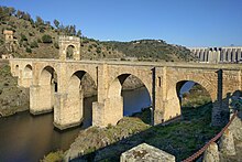
![](//upload.wikimedia.org/wikipedia/commons/thumb/1/1a/El_puente_de_Alc%C3%A1ntara%2C_C%C3%A1ceres.jpg/220px-El_puente_de_Alc%C3%A1ntara%2C_C%C3%A1ceres.jpg)
Alcántara Bridge
![](http://upload.wikimedia.org/wikipedia/commons/thumb/0/06/Atlas_de_statistique_graphique_-_18._Paris_1888._Recettes_kilometriques_des_ligne_d%27Omnibus_-_David_Rumsey.jpg/220px-Atlas_de_statistique_graphique_-_18._Paris_1888._Recettes_kilometriques_des_ligne_d%27Omnibus_-_David_Rumsey.jpg)
![](http://upload.wikimedia.org/wikipedia/commons/thumb/4/46/Bell_Rock_Lighthouse.jpg/220px-Bell_Rock_Lighthouse.jpg)
![](http://upload.wikimedia.org/wikipedia/commons/thumb/1/1a/El_puente_de_Alc%C3%A1ntara%2C_C%C3%A1ceres.jpg/220px-El_puente_de_Alc%C3%A1ntara%2C_C%C3%A1ceres.jpg)
- Maps
- Lighthouse
- Viaduct
- Parking lot
- Overhead cables
Cost
[edit | edit source]- Cost-benefit analysis
- Passengers
- Subsidy - Roads are the most subsidised infrastructure especially controlled access highways (freeways, motorways).[1]
- Space
- Traffic flow
- Demand (induced)
The longest tram line in the world at 42 miles is Coast Tram (Belgium).