Template:Location map Australia/doc
Jump to navigation
Jump to search
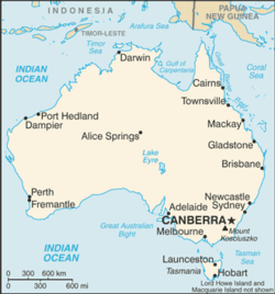
Map of Australia 


| This is a documentation subpage for Template:Location map Australia It contains usage information, categories and other content that is not part of the original template page. |

Template:Location map Australia is a location map definition used to overlay markers and labels on an equirectangular projection map of Australia. The markers are placed by latitude and longitude coordinates on the default map or a similar map image.
Usage
[edit source]These definitions are used by the following templates when invoked with parameter "Australia":
{{Location map|Australia |...}}{{Location map+|Australia |...}}{{Location map~|Australia |...}}
Map definition
[edit source]- name = Australia
- Name used in the default map caption
- image = Australia location map.svg
- The default map image, without "Image:" or "File:"
- image1 = Australia relief map.jpg
- An alternative map image, usually a relief map, can be displayed via the relief or AlternativeMap parameters
- top = -9
- Latitude at top edge of map, in decimal degrees
- bottom = -44.5
- Latitude at bottom edge of map, in decimal degrees
- left = 111.5
- Longitude at left edge of map, in decimal degrees
- right = 155
- Longitude at right edge of map, in decimal degrees
Alternative map
The map defined as image1 (Australia relief map.jpg) can be displayed by using the relief or AlternativeMap parameters in {{Location map}} and {{Location map+}}. The use of these two parameters is shown in the examples below.
Examples using location map templates
[edit source]Location map, using default map (image)
[edit source]
Canberra
Canberra (Australia)
{{Location map | Australia
| width   = 200
| lat_deg = -35.31
| lon_deg = 149.12
| label   = Canberra
}}
Location map+, using AlternativeMap
[edit source]
Canberra
Perth
Two locations in Australia
{{Location map+ | Australia
| AlternativeMap = Australia relief map.jpg
| width   = 200
| caption = Two locations in Australia
| places  =
  {{Location map~ | Australia
  | lat_deg = -35.31
  | lon_deg = 149.12
  | label   = Canberra
  }}
  {{Location map~ | Australia
  | lat_deg = -31.95
  | lon_deg = 149.12
  | label   = Perth
  }}
}}
See also
[edit source]- Template:Location map, to display one mark and label using latitude and longitude
- Template:Location map+, to display an unlimited number of marks and labels