Planet Earth/5d. Surface Ocean Circulation
An Ill Fated Expedition to the North Pole
[edit | edit source]
Encased in ice, the American ship Jeannette was being crushed, its wooden hull cracking and breaking under the intense cold grip of the frozen ocean. For the past month, the ship had been entrapped in the arctic ice. The crew scrambled as they off-loaded boats onto the flat white barren landscape. They dragged the boats with them, as they watched with horror the splintered remains of the ship sink between the icy canvasses of the frozen Arctic ocean. The expedition was headed toward the North Pole, led by their captain George W. De Long, a United States Navy officer who was on a quest to find passage to the open northern polar sea. His ship sinking beneath the ice, left his crew isolated upon the frozen ocean. De Long took out his captain log book, and listed the location of the sinking ship, 77°15′N 155°00′E / 77.25°N 155°E, before ordering the men to drag the boats and whatever provisions they had remaining across the vast expanse of ice.


Once they reached open water, they set their boats into the non-frozen waters and rowed southward. Chief Engineer George Melville, a stoic figure with a long prophetic beard, led one group of survivors. Melville had worked his way up in the Navy, helping to establish the United States Naval Academy, was a veteran of such dangerous Arctic explorations. In 1873, he volunteered to help rescue the survivors of the ill-fated Polaris expedition, an attempt to reach the North Pole. Now trapped in a similar situation George Melville watched as the various boats were tossed on the open water and soon became separated in the night. It was the last time he would see Captain De Long, alive. His small crew on the boat would survive after landing on the shores of the Lena Delta on the northern coast of Siberia. For the next year, Melville searched for De Long, and finally discovered his body, and those of 11 crew men. He also found the captain’s log book that recorded their furthermost approach to the North Pole. Melville wrote of the ill-fated expedition, and the search for the Captain in a book published in 1884.


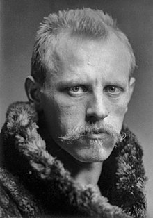
That same year, 1884, the wreckage of their ship was discovered off the coast of Greenland. The ship despite sinking in the ice north of Siberia, had somehow traveled across the Arctic ocean carried by the polar ocean currents to Southern Greenland, thousands of miles away. The long voyage of this wreckage, sparked an idea for another attempt to reach the North Pole by the Norwegian explorer Fridtjof Nansen to purposely sail a steamship into the ice, and let the ice carry the vessel as close as possible to the North Pole. Once the trapped ship reached the furthermost distance north in the ice, a dog sled team could disembark from the ice encased ship, and travel the remaining miles over frozen sea ice to reach the northernmost point on Planet Earth. It was a daring plan, that required knowledge of the motion of ocean currents and sea ice in the high arctic.

The steamship Fram sailed from Norway following the coast of northern Siberia, then looped back heading northward until it encountered the ice. For three years the ship was carried on its northward then westward journey trapped and encased in ice, when it reached its most northern point on March 14 1895, Fridtjof Nansen and Hjalmar Johansen disembarked from the ice trapped ship, and headed even further north by dog sled. Nansen would record a northern latitude of 86°13.6′ North on his sextant, before turning back, unable to reach the north pole at 90° N. Over the next year the two men traveled southward over the sea ice, and miraculously both men would survive the journey. The ice trapped steamship and its crew was released from the ice and was able to sail back successfully to Norway. No crew member died with the attempt, and despite not reaching the North Pole, the expedition was viewed as an amazing success. A marine zoologist by training, Nansen returned home and dedicated himself to studying the ocean.
How Ocean Currents Move Across Earth
[edit | edit source]
Fridtjof Nansen remained puzzled how ocean currents move across Earth. He was particularly interested in how icebergs and stranded ships are carried by the ocean. During the expedition, Nansen utilized the Transpolar drift an ocean current that flows from the coast of Siberia westward toward Greenland, driven by a large circular current called the Beaufort Gyre, that encircles the North Pole. In oceanography, a gyre is a large circulating ocean surface current. The Beaufort Gyre spins clockwise around the North Pole, while Earth spins in a counterclockwise direction around the polar axis. Nansen reasoned that the reason the surface of the ocean spins in the opposite direction to the Earth is that unlike the solid earth, the liquid ocean (and the atmospheric gas above) are only loosely attached to the surface of the Earth, the inertia of the Earth’s rotation and drag, causes the liquid to trail or lag behind the motion of the solid Earth. When Nansen’s ship was trapped in the sea ice, the Earth rotated around below the ship, while the liquid ocean, carrying the frozen sea ice and trapped ship appeared to resisted this motion, and hence the coast of Greenland was brought toward the ship, as the solid Earth rotated below it. However, Nansen realized that this was not true, since the ocean and solid earth travel around the axis at nearly the same constant velocity and same inertia. The ice and ocean currents should rotate in-sync with the rotating Earth. During the expedition, Nansen noticed that ice drifted at an angle between 20° to 40° to the right of the prevailing wind direction, he suspected that the ocean currents were influenced by prevailing wind directions instead.
Nansen contacted Professor Vilhelm Bjerknes at the University of Uppsala, who was studying fluid dynamics. Bjerknes thought the ocean currents were largely controlled by the Coriolis force arising from the motion of the Earth, but suggested that his brightest student, Vagn Walfrid Ekman undertake the study for his doctoral research. Ekman was the opposite of the rugged Arctic explorer Nansen. Ekman was studious with thick eye glasses and a petite gentle frame. He was more comfortable with mathematic equations and played the piano and sung in a local choir.

Fluid dynamic experiments carried out with rotating bowls of water at a constant velocity showed that spinning the bowl (with zero acceleration), there was a stabilizing effect when drops of colored dye were added to the water from above. This is because the point or location the dye was added to a spinning bowl of water had the same speed and same inertia as the spinning bowl beneath it. In fact, the color from the dye was observed to form a narrow column, and not rotate in relation to the spinning bowl beneath. This seemed to suggest that the Arctic exploring feat of Nansen was an impossibility. However, if dye was added to the spinning bowl of water from the side, the dye would quickly spiral due to the Coriolis effect, as the dye was moving across different radii, and hence its velocity was changing due to this horizontal motion.
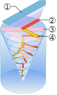
Ekman suspected that in the open ocean there were various forces working to change the velocity or speed of the ocean water that would destabilize the water and result in its motion. Ekman defined two boundaries, known as Ekman Layers, the first of which is the ocean floor. The ocean floor is not flat, but has a complex topography, this boundary is the most rigid as it is under the most pressure from water above. The second Ekman Layer is the ocean’s surface. Here the ocean is affected by blowing wind, and is under the least amount of pressure. The prevailing wind would be governed by geostrophic flow, that is affected by a balance between atmospheric pressure gradients, and the Coriolis force; these geostrophic winds tend to travel parallel to an air pressure gradient. Wind would only affect the uppermost portion of the ocean, maybe only to depths of 10 meters. This pressure gradient between the two Ekman Layers of the ocean results in changes in velocity between each layer, resulting a shearing of the liquid ocean, as the upper part is influenced by the wind direction and the lower part is influenced by the rotating Earth. Using mathematical formulas, Ekman demonstrated that this motion would result in a spin or spiral motion within the ocean, known as the Ekman Spiral.
At the surface of the ocean, the direction of horizontal motion would be greatest, because of the influence of geostrophic winds on the ocean surface. The geostrophic winds would drive the ocean water below them to flow perpendicular to the Coriolis direction, however, since the water is not influenced by the air pressure gradient, they will be more affected by the Coriolis direction resulting in a current that is at an angle between 20° to 40° to the right (in the Northern Hemisphere) of the prevailing wind direction. The Ekman Spiral, and the mathematics that Ekman developed allowed a profound understanding of the motion of ocean currents.

The Ekman Spiral has several important implications. First is that surface, or near surface ocean waters move the quickest, while deep ocean waters are much less mobile, and are more permanently fixed to the ocean floor. Oceanographers describe the motion of ocean water circulation across the Earth into two very different patterns. Those of surface ocean circulation are much more mobile, with surface ocean water circulating across the planet very quickly (a few months to several years), while deep ocean circulation is much slower, with long term patterns of deep-water circulation lasting hundreds or thousands of years. The Ekman Spiral also demonstrated how Nansen’s daring expedition was able to be successful, since the ship was trapped in sea ice at the surface, it was affected by the prevailing geostrophic easterly winds that blow across the Transpolar drift, in addition to the Coriolis Effect spinning the Beaufort Gyre in a clock-wise direction. This resulted in surface ocean waters and sea ice to travel at an 20° to 40° angle to the prevailing wind direction, and resulted in Nansen’s near successful attempt at reaching the north pole.
Upwelling and Downwelling
[edit | edit source]


Ekman’s spiral is useful in understanding how ocean water can move vertically through the water column, especially within ocean water near coastlines along the continental margins. This upwelling and downwelling occurs when wind directions drive ocean currents either toward or away from the coastline. If the prevailing wind is blowing and results in surface ocean currents that move from the ocean toward the land and these surface ocean currents are perpendicular to the coastline, the surface ocean waters will result in a downwelling of ocean waters, as the ocean water is pushed deeper when it reaches the coast. However, when the prevailing wind is blowing from land out across the ocean and the surface ocean current is perpendicular to the coastline in the opposite direction, upwelling occurs, as the surface ocean water will be pushed away from coastline, bringing up deeper ocean water to the surface. Often however, the prevailing surface ocean currents are not simply perpendicular to the coastline, resulting in a flow of water called a Longshore Current. Longshore currents depend on a prevailing oblique wind direction that transports water and sediments, like beach sand along the coast parallel to the shoreline. When longshore currents converge in opposite directions, or there is a break in the waves, a Rip Current will form that moves surface ocean water away from the shore and out to sea. Rip currents are dangerous to swimmers, since the strong currents will carry unsuspecting swimmers away from the shore. It is important to note that the upwelling and downwelling of ocean water resulting from Ekman’s research is relatively shallow across the entire ocean, and occurs mostly along the shallow coastlines of islands and continents. The deepest ocean waters in the Abyssal Zone require a different mechanism to raise or lower these deep ocean waters to the surface, which will be discussed later. However, the discoveries and mathematical models of Ekman are important in understanding surface ocean circulation around the world.
Surface Ocean Circulation
[edit | edit source]
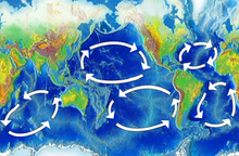
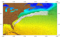
Surface ocean circulation in the Northern Hemisphere will spin toward the right in a clockwise direction, while in the Southern Hemisphere surface ocean currents will spin toward the left in a counter-clockwise direction. One of the most well-known surface ocean currents is the Gulf Stream, which extends from the West Indies, through the Caribbean, north along the eastern Coast of the United States and Canada, and brings warm equatorial ocean waters to the British Isles and Europe. The Gulf Stream is part of the larger North Atlantic Gyre, which rotates in a large clock-wise direction in the Northern Atlantic Ocean. The Gulf Stream brings warm ocean waters to the shores of Western Europe, resulting in a warmer climate for these regions. The Canary Current, which travels southward from Spain off the coast of Africa, results in colder surface ocean waters traveling toward the equator, where currents meet the North Equatorial Current completing the full circuit of the North Atlantic Gyre. In the Southern Atlantic Ocean, the surface ocean current rotates in a counter-clockwise direction. Traveling west along the southern equatorial current, then south along the coast of Brazil, east crossing the South Atlantic, and then north along the coast of the Namibian Coast, in a counter-clockwise circuit, as the Southern Atlantic Gyre. The center of both the Northern and Southern Atlantic Gyre, surface ocean currents remain fairly stagnant. Early sailors refer to the center of the Northern Atlantic Gyre as the Sargasso Sea, named because of the abundance of brown seaweed of the genus Sargassum floating in the fairly stagnant ocean waters. Today these regions of the North and South Atlantic Ocean are known by a much more ominous name, the garbage patch. Plastics and other garbage dumped into the oceans accumulate in these regions of the ocean, where they form large floating masses of microplastic polyethylene and polypropylene which make up common household items which have been dumped and carried out into the oceans.
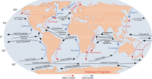
Between the Northern and Southern Atlantic Gyre is a region that sailors historically referred to as the doldrums, which is found along the equatorial latitudes of the Atlantic Ocean. Here surface ocean waters are not as strongly affected by the Coriolis force, because the ocean water is carried in the same direction as the rotation of the Earth. This results in what is known as the Equatorial Counter-Current. The equatorial counter-current carries surface ocean waters from the west to the east, in the opposite direction as the easterly trade winds that carry sailors from the east toward the west near the equator. The equatorial counter-current is a result of the Intertropical Convergence Zone (ITCZ) winds which form a low-pressure converging zone as atmospheric air rises due to the increase in heat from the sun in these warm waters.
Sailing ships avoid these regions, as they can significantly slow the progression of sailing ships dependent on surface ocean currents and prevailing winds. Sailors traveling from Europe to North America follow the easterly trade winds north of this zone, while returning sailors traveling back to Europe following the westerly trade winds of the Gulf Stream, crossing the Northern Atlantic Ocean more north than their voyage to North America. This resulted in early trade routes across the Atlantic following the coast from the West Indies north toward New York, resulting in goods being transported from the south to the north along the Eastern ports of North America. While the Caribbean Islands were some of the first places European and African traders arrived at in the North Hemisphere after traversing the Atlantic Ocean. Ships today are less influenced by surface ocean currents and prevailing winds with engines that drive propellers under the ships. However, surface ocean currents do determine the flow of lost cargo from ships, and are useful for rescuing stranded sailors who are at the mercy of the ocean and its currents.
The Pacific Ocean mirrors the surface ocean currents of the Atlantic, but is at a much larger scale. Similarly, there are two large gyre. In the North Pacific, the North Pacific Gyre is a flow of surface ocean currents that follows a clock-wise direction. With warm equatorial waters moving northward along the Asian coasts, into Korea and Japan, the Kuroshio Current. This current, like the Gulf Stream is a warm current moving northward, the current passes over the North Pacific, before flowing toward the south along the Western Pacific Coast of North America, where it is known as the Californian current. This motion of warm equatorial water across the North Pacific results in a similar warming along the northern coastline of North America. It also moves floating debris from the coast of Japan to the Pacific Northwest coasts of Canada and the United States. Although because the Pacific Ocean is larger than the Atlantic Ocean, the ocean water has cooled slightly. Nevertheless, this Pacific Northwest surface ocean water is warmer than would normally be expected at such high latitudes. For example, the average annual temperature in Vancouver, Canada at latitude 49.30° North is 11.0 °C, while Halifax, Canada (along the North Atlantic Coast) at latitude 44.65° North is just 6.5 °C, despite its more comparatively southern latitude. These warm surface ocean currents may have left much of the North Pacific Coast of North America ice free during past Ice Ages, when large ice sheets covered the interior of Canada. The now cooling waters move southward along the Pacific Coast of the United States resulting in cooler, more temperate climates for Southern California, than would be expected given the more southern latitude of cities like Los Angeles. Surface Ocean Currents have a profound effect on local climates.
The South Pacific Gyre spins in the opposite direction as to the north, in a counter-clockwise direction. This results in warm equatorial ocean surface currents to flow into South Australia and off the coast of New Zealand, bringing warm water to these regions. The East Australian current, like the Kuroshio and Gulf Stream warms these regions, including the Great Barrier Reef southward into Sydney Harbor. The surface ocean circulation then transverses the South Pacific, but cools as it is pushed along the Antarctic Circumpolar current, the Peru current brings cold waters along the western coast of South America, clear up toward the Galápagos Islands. Despite the equatorial latitude, the waters off the Galápagos Islands are relatively cool compared to other equatorial ocean waters due to this cooler Peru current. Penguins occupy the rocky shore line of the islands, at their most northward range. Just like in the Atlantic Ocean, a large Equatorial Counter Current flows toward the east within the ITCZ, producing doldrums in the Pacific as well.
The Indian Ocean, unlike the Atlantic and Pacific Oceans is mostly south of the equator, and hence only has one large surface ocean gyre that rotates in the counter-clockwise direction. There is an Equatorial Counter-Current that flows toward the east off the southern coast of India, as a result of the ITCZ. This zone shifts northward over the Indian Subcontinent annually, producing the Indian Monsoonal rains each year. East Africa and Madagascar enjoy warmer tropical ocean currents similar to the Gulf Stream, Kuroshio, and East Australian Currents, making these regions also susceptible to typhoons and hurricanes.

The last surface ocean current is by far one of the most important: the Antarctic Circumpolar Current, also known as the West Wind Drift, which encircles the coast of Antarctica. Most of the currents we have discussed are a product of the rotation of the Earth, as well as the arrangement of the continents, which block the motion of the ocean toward the east, resulting in the many gyre discussed above. The Antarctic Circumpolar Current flows toward the east, and because there is no major landmass in its path, continues this flow in perpetuity, always encircling the coast of Antarctic. These ocean waters remain cold, bitterly so compared to other ocean currents, because surface ocean currents do not loop toward warmer equatorial regions of the planet.

The advent of the Antarctic Circumpolar Current occurred at the beginning of the Oligocene Epoch, 33.9 million years ago, when the Drake Passage that separates South America and Antarctic opened, allowing ocean currents to flow between the two continents, and preventing cold Antarctic ocean waters to be conducted northward. Instead, from this point onward, the Antarctic Circumpolar Current significantly cooled Antarctica, resulting in massive ice sheets to form on the continent, and making it the inhospitably cold place that it is today. The Antarctic Circumpolar Current had a global effect on the planet, resulting in cold global temperatures that led to the beginning of the Great Ice Ages. Millions of years prior to this event, a no longer existing Global Equatorial Current existed, which passed between North and South America, and extending through the ancient seaway known as the Tethys that separated Africa and Europe and covered the Middle East. This current at the equator, resulting in some of the warmest global climates for Earth during the Eocene Epoch around 50 million years ago. Surface ocean currents have a major effect on regional and global climate, because they are a way, through convection, to bring warm and cold ocean water to different parts of the Earth’s surface.
| Previous | Current | Next |
|---|---|---|