
Planet Earth/4g. What are Clouds?
Clouds
[edit | edit source]On a summer day, clouds might float overhead, their passage only noticed if you take the time to observe them. Clouds come in all shapes and sizes, but their unique physical properties can be classified, and sky-gazers have come up with names based on the characteristics of clouds on Earth. The names are composed of Latin words, Nimbo- for rain, Alto- for high, Cumulus- for heap or mound, Strato- for flat, and Cirrus- for curl or wisp.
Cumulus clouds
[edit | edit source]_(Yellowstone,_Wyoming,_USA)_(28191827302).jpg)
These clouds are the classic white puffy, cotton-candy like clouds you observe on a late summer afternoon. The tops of the cloud are often rounded, as the cloud grows upward, with a flat base that may be a few hundred meters above the ground. In the late afternoon, cumulus clouds can grow larger forming a cumulus congestus, or towering cumulus. If enough moisture develops in a cumulus cloud, and it grows even bigger, and grayer, it can turn into a cumulonimbus cloud.
Cumulonimbus clouds
[edit | edit source]
These clouds are towering giant clouds associated with thunderstorms. Climbing upward into the atmosphere more than 12 kilometers, these clouds can release huge amounts of rain, snow, hail, and are associated with lightning and thunder and even tornadoes. Near the top they will sometimes form anvil heads. Near the base they will form a grayish or bluish color, because of the super saturation of water vapor. Often rain or snow will fall beneath a cumulonimbus cloud. Evening summer thunderstorms are often a result of cumulonimbus clouds.
Stratocumulus clouds
[edit | edit source]
These clouds resemble cumulus clouds that are flattened, and usually manifest in the sky in low groups or lines of clouds. These clouds lack much height, often due to stable air above which prevents upward growth. Rarely do these types of clouds produce rain or snow, and they tend to precede warming weather. Stratocumulus clouds often form lines or lenticular patterns in the sky.
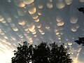
Altocumulus clouds
[edit | edit source]
These clouds resemble individual scattered globular patches in the sky, found higher up in the sky. These high patchy clouds do not often produce rain, but have been known to evolve into cumulonimbus clouds. Altocumulus clouds often speckle the sky, and can vary in thickness, with some being thin wispy clouds, while others thicker and more bulbous.
Cirrocumulus clouds
[edit | edit source]
These clouds are high altitude clouds, that are found near the top of the troposphere, between 10 and 14 kilometers above the surface of the Earth. These clouds often contain more ice crystals than liquid water, and can produce snowflakes on cold days. They can form from the breakup of large clouds, like cumulonimbus clouds after a storm.
Cirrus clouds
[edit | edit source]
These clouds form high in the troposphere, around 14 to 16 kilometers, and produce thin wispy clouds high in the sky. Cirrus clouds are composed of ice crystals that originate from the freezing of supercooled water droplets. They often appear transparent, like wedding veils high in the sky.
Stratus clouds
[edit | edit source]
These clouds are very low flat and featureless clouds that roll across the sky during the beginning of a cold front. Often stratus clouds are gray and dark in color, but sometimes can be white. Foggy and low to the ground, these clouds will hug mountains and hills, and represent an extended period of colder weather with rain and snow. Most fog is classified as stratus clouds, which can form in the cooler morning hours or after rainstorms.
Nimbostratus clouds
[edit | edit source]
These clouds are similar to stratus clouds, but are much thicker and darker, and are associated with cold fronts. Nimbostratus clouds are observed during significant rain and snow accumulations that follow a cold front, and often found in the sky on cold rainy or snowy days. These clouds often blanket the entire sky on cold rainy days, but only extend upward 2 to 4 kilometers. If the sky is completely covered in clouds, on a cloudy day, it is often a result of nimbostratus clouds.
Altostratus clouds
[edit | edit source]
These clouds are similar to altocumulus clouds, but are thicker, and spread out over the sky at heights between 6 and 10 kilometers. They are not as wispy or transparent, and can cover much of the sky with clouds. Since they are higher in the sky, they tend not to be associated with rain or snow, but hang over the landscape as featureless clouds.
Unusual or Rare Cloud Formations
[edit | edit source]-
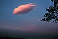 Lenticularis cloud
 -
 Virga clouds
 -
 Mackerel sky
 -
 Nacreous clouds
 -
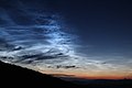 Noctilucent clouds
 -
 Mammatus clouds
 -
 Arcus clouds
 -
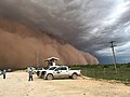 A Haboob in Texas
 -
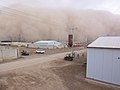 A Haboob in Iraq


.jpg)


A number of strange cloud formations have been given names and described. The most iconic is likely the Lenticularis clouds, which resemble gigantic circular UFOs. They are a type of altocumulus cloud which are carved by wind into oval-like shapes high in the sky. Virga clouds are thin wispy clouds that drape down from rain clouds. Virga are caused by precipitation that falls from the underside of a cloud, often the moisture evaporates before it reaches the ground, although it can cause a light shower of rain or snow directly below its veil. Mackerel Sky is a sailor term for a sky filled with rows of small cirrocumulus or altocumulus clouds displaying a speckled pattern of clouds that look slightly like the scales of mackerel fish, caused by high altitude atmospheric winds. Mackerel Skies are often used by sailors to forecast rain, since they occur as barometric pressures fall, indicating a low-pressure system is developing. Nacreous clouds are only found in Arctic regions, and are high iridescent-colored clouds that form near the top of the Troposphere when the atmosphere is extremely cold. They are most often observed in cold and dry polar regions, and are formed from ice crystals high in the atmosphere. They are often referred to as polar stratospheric clouds, and are sought after by cloud watchers. Noctilucent clouds are scientifically interesting rare clouds that are found within the Mesosphere, at very high altitudes above Earth. They are often observed following a major volcanic eruption, and are thought to be caused by volcanic dust and water vapor that is injected into the high Mesosphere where they form wispy thin clouds best seen near sunset or sunrise. They have been observed after rocket launches, when particulates and water vapor are carried high into the atmosphere from the rockets as they combusted fuel during lift off. Mammatus clouds are pillow-like clouds that can form below cumulonimbus clouds, the term comes from the Latin word for breast or utter, mamma. Kelvin–Helmholtz clouds are caused by velocity differences between two layers of the atmosphere, which results in wave-like clouds that resemble crashing ocean waves. They are named after English physicist Lord Kelvin and German physicist Hermann von Helmholtz who both described the physics of these wave formations in the 1860s and 1870s. Arcus clouds are a rare kind of storm clouds that rolls across the sky. They are associated with cold fronts and thunderstorms, which cause the clouds to appear to roll over the landscape. They are known by other names, including Roll clouds, Shelf clouds, or Volutus clouds. Arcus clouds are related to the phenomena of rolling giant dust clouds called haboob, which comes from the Arabic term for blasting or drifting. Haboobs form where strong gushes of wind blow across an arid landscape lifting dust and particles into the air. They proceed thunderstorms and advancing lower pressure fronts, which bring strong winds. Haboobs can cause respiratory problems since these airborne dust particles can be breathed in by people trapped in these storms. Sun dogs, or parhelion are strange and rare atmospheric events that cause the sun to appear to have two bright spots that flank the sun on either side. These sun dogs are caused by ice crystals within cirrus or cirrostratus clouds reflecting a large halo around the sun around 22 degrees to either side. These Sun dogs can be particularly bright when the sky contains thin cirrus clouds which reflect the sunlight passing through them.

How clouds form, moisture in the atmosphere
[edit | edit source]Clouds are intricately intertwined with the phases of water in the atmosphere; liquid water, water vapor, and ice/snow. Changes in the temperature and pressure near the surface of the Earth, in the Troposphere, can result in the formation of any of these phases through the process of evaporation (liquid → gas), condensation (gas → liquid), and precipitation (gas → liquid or solid). Liquid water is converted to a gas through evaporation, which occurs when excited molecules escape from a heated source of water and move into the air as water vapor. When the number of water molecules evaporating matches the number of water molecules condensing the air is considered saturated in relationship to water vapor. Saturated air is air that is at the maximum level of its possible concentration of water vapor at a given temperature and pressure. When air becomes oversaturated with water vapor, water will condense into liquid and can be seen as visible clouds in the sky.

Imagine a jet engine on an airplane flying at a set altitude, with no change in air pressure. Air passing through the jet engine will be heated by the engines resulting in an undersaturation of water vapor in the passing air through the engine’s exhaust, as the heated air now has the capacity to contain more molecules of water. The surrounding water molecules will rush into this undersaturated air, but as the air begins to cool several seconds after the jet engine and its heat has passed, the air will become oversaturated in respect to water vapor, and the water vapor will condense into a line of clouds in the sky. These contrails etch a path across the sky, leading to manmade clouds visible from Earth’s surface. If the air is already oversaturated in respect to water vapor, and the jet engine passes through a cloud of condensing water, the passing jet engine can heat the air, increasing the saturation of water vapor, and cause the cloud to disappear. These events can form fallstreak holes or trails through natural forming clouds.
Clouds form anytime the temperature or pressure of the air moves from saturation to oversaturation, with oversaturation of water vapor resulting in the condensation of liquid water and the formation of clouds in the sky.
Dalton's law
[edit | edit source]On the morning of July 26, 1844, when the elderly John Dalton recorded his meteorological observations for the day, he wrote shakily 60 for the temperature inside his apartment, 71 for the temperature outside, 30.18 for the barometer reading, SW 1 for a gentle southwest wind direction, and the observation, Little Rain. 60, 71, 30.18 SW 1, Little Rain. It was the last entry in a series of over 200,000 weather recordings that John Dalton had first begun in 1787, when he was only 21 years old, although with more earnest in 1794. Now, an old man, his entire life was recorded by the weather observed each day of his long life, a total of 57 years of weather observations. When he died the next day of a stroke, thousands of people across Manchester, England, came to his funeral. He was famous, not for his diligent record he kept of the weather or his small shabby apartment, and his stoic life as a life-long bachelor, John Dalton was well respected because of his keen understanding of the relationship between gas and pressure, and the discovery that atoms or molecules of gas contain masses of differing sizes.

Today, atmospheric scientists know him for developing Dalton's law, which states that total pressure exerted by a mixture of gasses is equal to the sum of the partial pressures of each individual gas within the mixture. For example, in air at sea level, under 101.3 kPa of pressure, Nitrogen will exert 78.1 kPa of pressure, Oxygen 20.9 kPa of pressure, Argon 0.97 kPa, water somewhere around 1.28 kPa, and carbon dioxide 0.05 kPa, in direct relationship to the percentage of each gas within the mixture of gasses found within normal air at sea level.
This means that if water vapor is added to a gas, the total pressure of the gas will increase. Saturation pressure of water vapor is the maximum water vapor capacity at any given temperature for a mixture of gasses. If the added water vapor is more than the saturation pressure of water vapor, then the gas will begin to condense, appearing as liquid water, with molecules moving from the gas to liquid phase. The vapor pressure cannot be higher than this maximum capacity, so any gas that is higher than the saturation pressure, will result in the condensation of water. However, air can be under-saturated. Relative humidity is the ratio of the water vapor pressure in air, with respect to the saturation water vapor pressure, or maximum capacity of the air to hold water vapor.
If relative humidity is 100%, then condensation of water vapor will occur. However, if the relative humidity is only 15%, then the air is undersaturated in respect to water vapor. The saturation pressure of water vapor is dependent on the temperature, the higher the temperature the more water vapor the air can hold, for example a recording of atmospheric gas at 40 degrees Celsius with 95% relative humidity, will have a considerable larger total amount of water vapor, than atmospheric gas at 0 degrees Celsius with 95% relative humidity. This relationship results in sticky, muggy, hot weather, in places with an abundance of liquid water, while cold regions will be drier. Hot places, like arid deserts that lack a source of liquid water, such as deserts in the interior of continents, will often be highly undersaturated in respect to water vapor, with very low humidity, such as 5 to 25% common. Note that when relative humidity reaches 100% condensation occurs, and clouds, precipitation, or fog will form. Note that when temperatures drop, the saturation water vapor pressure will change, resulting in a rise in relative humidity without changing the amount of water vapor in the air. If this cooling air reaches a relative humidity of 100%, condensation will occur and clouds will form, this is referred to as the dew point.
Adiabatic Lapse Rate
[edit | edit source]The best way to think about the Adiabatic Lapse rate is to think of it as a track, forcing air or any material under different pressures and temperatures to follow a very specific passage with altitude. Adiabatic Lapse is a result of how temperature and pressure are related. You may have observed how a canister of compressed air will cool, even growing ice crystals on its surface when gas inside the canister is released. While increasing the pressure inside a tire, the tire will grow hot from the increase in air pressure. When air expands it cools, when air is compressed it heats up. Imagine hot air rising, as it rises the air expands, resulting in the air cooling down as it rises. Imagine cold air sinking, as it is compressed with more pressure, the air will warm. This process is an adiabatic process, which means that air moving between elevations will follow a narrow path along temperature and altitude. This Adiabatic Lapse is 10 degrees Celsius colder every 1 kilometer of altitude (10°C/km). Above an area of Earth’s surface that is 30 degrees Celsius, the air 3 kilometers above will be 0 degrees Celsius. If that air mass moves closer to the Earth, dropping to an altitude of 2 kilometers above Earth, the temperature of the air mass will increase by 20 degrees Celsius. It is important to note that the adiabatic lapse rate is a physical condition of the motion and expansion/contraction of air under different pressures, and not caused by the temperature profile of the Earth. If there was no temperature differences between the layers of the atmosphere, any air that rises and expands would cool, and any air that sinks and contracts would warm.
This Adiabatic Lapse is called the dry adiabatic lapse rate because we assume the air is dry, and below the Saturation pressure of water vapor. However, if the air is cooling as it rises, the air will reach a point where it will be unable to hold as much water vapor and eventually, with enough altitude and cooling, the saturation pressure of water vapor will be reached, and condensation will occur, at which point clouds will form. Clouds form at high altitudes because the air mass cools below the saturation pressure of water vapor for the concentration of water vapor within the rising air mass. If these air masses are moving upward, they will often cross this point forming clouds in the sky. If air moves swiftly higher, and carry a large amount of water vapor, the condensation of this water vapor with height will result in the possibility of significant precipitation of rain or snow. The moist adiabatic lapse rate is slightly less with an average of 6 degrees Celsius colder for every 1 kilometer of altitude (6°C/km). The Adiabatic Lapse Rate is the reason that clouds rarely form near the surface of the Earth, but often higher in the sky. Understanding the rising and falling of air, and changes in pressures observed from the surface of the Earth using a barometer is necessary for knowledgeable insight into the nature of wind on Earth and understand weather forecasting.
Clouds and Climate Change
[edit | edit source]As global temperatures in the troposphere have been rising over the last century with rising carbon dioxide and other greenhouse gasses, scientists have hypothesized that the world will become cloudier over time. Any addition of global cloud cover would increase the albedo of the Earth resulting in more sunlight reflected back into space. This would act like a negative feedback and cool the planet. Satellites launched into space, such as instruments aboard NASA’s Terra and Aqua satellites, as well as older satellites like NOAA’s High-Resolution Infrared Radiometer Sounder (HIRS) have been measuring the Earth’s cloud cover. Results since 1978 show that Earth’s cloud cover has not trended upward nor downward, but appears to vary yearly within a narrow range. Slight changes observed seem to reflect enhanced atmospheric circulation, but no net increase in cloud cover since observations begun in the late 1970s.
| Previous | Current | Next |
|---|---|---|