Planet Earth/1d. How to Navigate Across Earth using a Compass, Sexton, and Timepiece
How to Navigate Using a Compass
[edit | edit source]
In an age where you can quickly determine your position on Earth in Latitude and Longitude with high precision, it may seem strange to learn about navigation methods using a Compass, Sextant and Timepiece, since most explorers of the Earth carry a GPS unit with them on their trips, or at least have a smart phone, or other electronic device with GPS capabilities. However, you may find yourself easily lost if that unit fails. You should prepare yourself to learn to navigate using older methods, including a compass, sextant and timepiece.
More than a thousand years ago, in China, it was discovered that rubbing an iron needle on a rock containing magnetite caused the needle to become magnetized. If the needle was placed through a cork and placed in a bowl of water, the needle would orientate itself along a specific direction as it floated on the surface of the water. Because all magnetized needles exhibit the same orientation, it became a useful tool for navigation. During the Song dynasty in China, about a thousand years ago, the compass was perfected as an orientating tool that travelers could carry with them, often with the magnetized needle balanced on a sharp point, under glass, to make it more practical than a cork in an open bowl of water. Widely regarded as one of the most important discoveries in China, a compass shows the cardinal directions (North, East, South, West), as they relate to the magnetized needle which is orientated along the Earth’s magnetic field.
The compass needle will orient itself along the north-south magnetic axis of the Earth, which differs depending on where you are, and changes with time. Typically, there is an N on the compass marking the direction of magnetic North. The needle will often have a red tip to indicate the southern direction, which you can line up with the S. When you hold the compass in your hand you can move it around until the needle lines up with the N and S, with the red tip (if there is one) pointing toward the S. The direction is now lined up with the Magnetic Poles of the Earth.
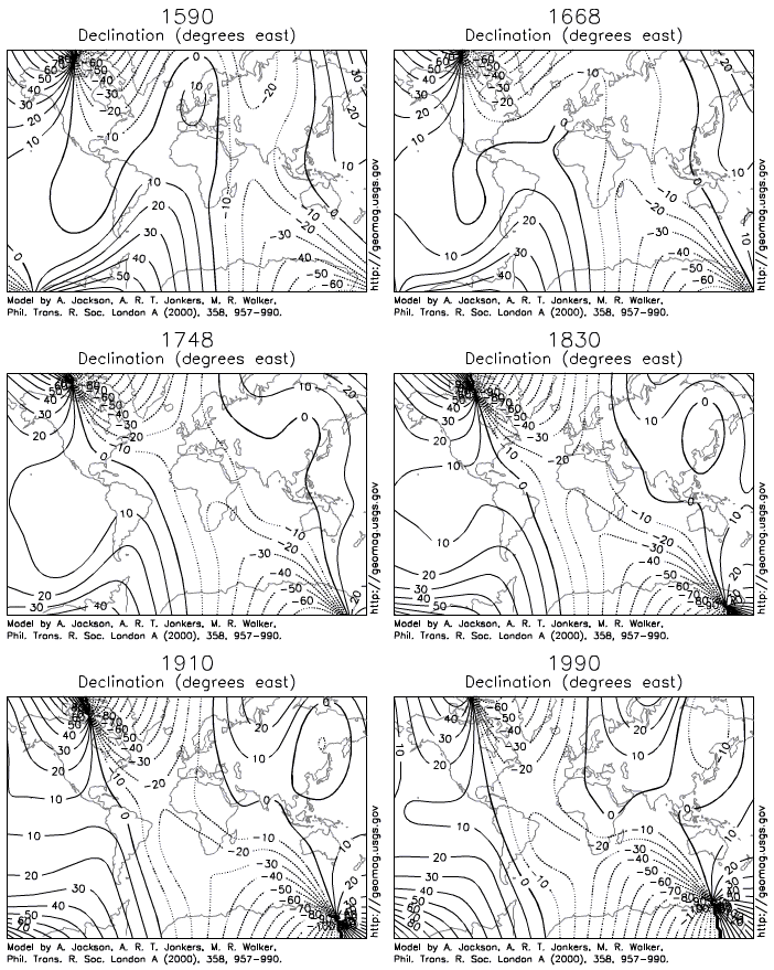
The North Magnetic Pole is a wandering point that currently is located at latitude 86.54°N and longitude 170.88°E, but wanders with an expected location in 2020 of 86.391°N 169.818°E. The oldest record of the magnetic pole’s location is in 1590 when it was found at 73.923°N 248.169°E. If the magnetic pole wanders so much, it may seem that a compass is an impractical tool for navigation. However, it is useful to get a quick bearing, as the magnetic needle often points north, unless you are high in the Arctic circle, or it can be adjusted if you know the declination of your location. A declination, sometimes called magnetic variation, is the angle between magnetic north and true north. Declination is written as degrees east or west from true north, or often shortened to positive degrees when east and negative when west. Magnetic declination changes over time and with location, so if you are using a compass for precise navigation you will need to keep it updated with your location.

The compass points along the magnetic axis, and a declination value is needed to obtain true north from a compass. Most topographic maps published by the United States Geological Survey will list the declination in the corner of the map, followed by a year. However, if you need to obtain the most current declination for your location you can look it up with the National Centers for Environmental Information, which is part of the National Oceanic and Atmospheric Administration of the Federal Government. They maintain an online Magnetic Field Calculator at (https://www.ngdc.noaa.gov/geomag/calculators/magcalc.shtml?#declination).
Once you found the current declination for your location, you will need to adjust your compass. For example, a declination 10° 21' E, you will need to have the needle point to 10° 21' E so that the N will point true north. Some compasses allow you to adjust the outer ring that marks the degrees that encircle the magnetic needle, so that you can set the declination for your location before you set out on a trip, for example by moving it right 10° 21' E, the compass needle will point true north, or N. Note that as a general rule in the United States locations west of the Mississippi River have an easterly magnetic declination, while east of the Mississippi River will have a westerly magnetic declination. A map of magnetic declinations is called an Isogonic Chart.

Compasses work because the Earth has a liquid and solid core made of mostly iron, which is magnetized because of its motion (called the Earth’s Dynamo). This solid inner core of the Earth orbits slowly over time, and results in a dynamic magnetic field that changes. Every few thousand or sometimes several millions of years, the magnetic pole will reverse directions. These reversals take several decades, and occur when the magnetic field of the Earth weakens. Several reversals have occurred in the last 1 million years, including an event 41,000 years ago, that only lasted 250 years, and another 780,000 years ago, which fixed the north and south magnetic poles at their current orientation. Magnetitic reversals are random events, likely due to the orientation of the solid and liquid iron core within the Earth. However, there have been some extremely long episodes during the age of dinosaurs in the Cretaceous Period when the magnetic field remained stable for millions of years. If the magnetic field undergoes a reversal during your life time, you will need to keep up to date with your local magnetic declinations, which may make using a magnetic compass problematic until the poles are fully reoriented.
Compass needles orient themselves relative to any magnetic field, such that if you hold a magnet close to the needle, the needle will orient to that field, causing the needle to be turned in orientation with the magnet. Some regions of the Earth have large deposits of magnetite, or iron ore that can cause compasses to not line up with the Earth’s magnetic field, such as the iron rich region north of Duluth Minnesota, or the mysterious Bangui magnetic anomaly in the Central African Republic. Also, be aware that high voltage electricity also emits a magnetic field, which can cause compass needles to not orient correctly if you are under a power line. There are also magnets found in mobile phones which also can cause the needles to not orient correctly when carried in a pocket with a mobile phone.
The Earth’s magnetic field is three-dimensional, such that the magnetic needle will not only point horizontally along the magnetic field but also tilt slightly vertical in orientation to a three-dimensional magnetic field. If you could measure this tilt on a compass needle, you could use it to determine latitude, as the needle will tilt more as you approach the magnetic poles. This technique has been used to determine ancient latitudes of Earth’s continents overtime, by measuring magnetic fields of the vertical tilt and horizontal orientation of magnetite grains buried in the rock record.
Compasses are used in navigation with a map, allowing a traveler to take a bearing. A compass bearing is the direction which you are headed, as shown by a compass and determined from a map.
Imagine that you are trying to find a cabin, and have come to a creek. You have a map showing the cabin on one side of creek, but you don’t know if you are on the same side of the creek as the cabin.

If the map has a north arrow, you can orient your compass with the arrow. Lay down the compass, and turn both the compass and map, until the map’s north arrow lines up with north on the compass. Now you will be able to determine if you are on the right side of the creek, since you will be facing the same direction as depicted on the map. You can also determine the direction of the cabin from your location, and take a heading (measured on the compass in degrees, either in 360 degrees, or quadrate NE, SE, SW, NW each representing 90 degrees). For example, you might find that the line from your location by the river to the cabin is 25° degrees to the Northeast). As you walk you try to keep the compass bearing of your travel at 25° degrees Northeast looking at the compass, until you reach the cabin. Taking a compass bearing helps travelers to orient their direction of travel, so they don’t walk in circles. This is especially useful in dense forests or jungles where you are likely to get lost or turned around.
During the Song dynasty in China, compasses were paired with an odometer, which measured a distance not with steps, but using a wheel that would tick off rotations, providing very accurate distances between towns and villages. However, map making was oriented in respect to what a traveler might see as they journeyed through a land. With the rise of Kublai Khan during the Yuan dynasty and visits from European traders on the Silk Road, such as Marco Polo in the 1330s, China turned toward explorations westward, along the coasts of India, Arabia and Africa. During the Ming dynasty the explorer Zheng He produced the Mao Kun map, a map using only compass bearings and distances on an annotated scroll. The map is unique since it reads like a series of instructions for navigating an ocean voyage, much like one would play through a video game.

How to Navigate Using a Sextant
[edit | edit source]For navigation it is often useful to calculate your position in latitude and longitude and this requires using two other tools, a sextant and chronometer.

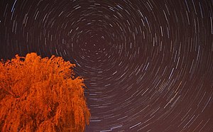
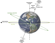
A Sextant is an instrument that measures the angle between an astronomical object, such as a star and the Earth’s horizon. It does this by using a mirror that reflects the sky against an image of the horizon, as you move the angle of the mirror. All you have to do is line up the astronomical object by changing the angle with the horizon line and read the angle measured. Often sextants have shaded glass to use if measuring the angle of the sun in the sky, so that you don’t damage your eye. One of the most important astronomical objects to measure using a sextant is the angle above the horizon to the star Polaris (the North Star). If you were to take a line through the axis of the North and South pole it would project northward toward a position near Polaris. Polaris can be found in the night sky by following the outer lip of the Big Dipper, or Ursa Major the Great Bear constellation. If you ever seen a time lapse photo of the night sky, all the stars will appear to rotate around this point in the night sky, because the Earth is rotating along this axis. This is called the Celestial North Pole. Once you have found Polaris in the night sky, you just measure the angle between the star and Earth’s horizon. The angle is equal to your latitude.


In the southern hemisphere, there is no bright star near the Celestial South Pole, to find this point in the night sky, you have to draw a line from two constellations in the night sky. Where the line from the two bright stars in the Southern Cross and the two bright stars in Centaurus cross is the Celestial South Pole. Since it is important for navigation in the Southern Hemisphere, the Southern Cross is depicted on the flags of Australia, New Zealand, Papua New Guinea and Samoa, as well as Brazil, which shows both the Southern Cross and Centaurus on its flag.
Using a sextant to find your latitude is fairly straight forward when at sea, since the horizon line is easy to find, but when you are traveling in canyons, mountain valleys, and dense jungles it can be difficult to determine the horizon line. To help with finding the horizon, a leveling bubble can be used instead of matching the horizon line.
A sextant can also be used to determine latitude during the day, by Noon Sighting, or measuring the angle of the sun at its highest ascent at the local noon time. This angle needs to be subtracted from 90° and is recorded as the zenith distance. To convert zenith distance into latitude, you can look up the declination of the sun for each day of the year in a Nautical Almanac, which lists sun’s declination for the noon hour for each day. By subtracting or adding the declination from the zenith distance, you can find your latitude, depending on the position of the sun in the sky relative to the hemisphere.
Latitude = (90º – Noon Sighting angle) + declination
Latitude = Declination – (90º – Noon Sighting angle)
How to Navigate Using a Clock
[edit | edit source]
If you measure the exact time of the sun’s highest ascent at the local noon time, you can compare this time with Greenwich Meridian Time (GMT), to determine longitude. If you maintain an accurate clock set to GMT, you can calculate your approximate longitude by adding 15° to each 1-hour difference observed from the local noon time if west of GMT. For example, if you record a local noon time of 5:00 pm GMT you are 75° West of the Greenwich Meridian. Note that you need to adjust for a slight difference between solar time and clock time, which differs by a few minutes depending on the time of year.
Rather than using a sextant, if you are on land, you can also use a gnomon or rod that casts a shadow and record the time set to GMT as the shadow length decreases during the approach to the local noon time, when the sun is highest in the sky. The GMT time at which the shadow is the shortest can be used to calculate the longitude, just remember to adjust for the slight difference between solar time and clock time.
Using these primitive methods, you can determine latitude and longitude within a kilometer (about a 1,000 yards), and this can be double checked with a modern-day GPS unit.
Public Land Survey System
[edit | edit source]Knowing latitude and longitude was of vital importance during times of war, and Thomas Hutchins fulfilled those duties as an Engineer mapping for the British Military in the mid-1700s. When hostilities broke out between the French and British forts in the western frontier of the American Colonies, Thomas Hutchins was called upon to map out the agreed peace treaty in 1763, which transferred land between the Appalachian Mountains and Mississippi River to British Colonial control, this region included the future states of western Pennsylvania, Ohio, Indiana, and Illinois. Hutchins also mapped parts of the Mississippi River and documented many of the native populations and mapped the various native towns along the rivers. He laid out plans for the city of Pittsburgh at the junction of the Ohio and Allegheny Rivers in western Pennsylvania, and mapped parts of Florida and Louisiana as well.
When the American Revolution broke out in 1776, he served with British forces, but was arrested for treason in sending coded messages to revolutionary forces. Taken to England, he escaped from prison, and made his way to France, where he met up with Benjamin Franklin, and returned to America as a patriot. After the war, Thomas Hutchins began mapping parts of Ohio using a new grid system, called the Public Land Survey System (PLSS). The public land survey system was a way to map a region by overlaying a grid of 36 numbered 1-square miles grids, with each set of 36 grids given a numbered township north or south and range west or east in reference to a local meridian line. For example, a location could be given as Section 10 Township 10 South Range 3 West. Indicating a square mile that was located in the 10th square of the 36-square mile grid, 10 townships to the south and 3 ranges to the west of the local meridian. As America’s first national geographer, the success of his system inspired its adoption by Thomas Jefferson, and all land west of the original American colonies, excluding Texas, would be mapped using this system over the next century.

The PLS system in the United States became the legal method to determine property lines, as lands were purchased during the Louisiana Purchase in 1803, or taken by force during the Mexican-American War in 1846. The PLS system was used by the United States to allocate land ownership, and used to push European settlement westward with the acquisition of lands from native tribes and peoples. Having an accurate grid map of a large land mass is a major advantage during conflict. Surveyors were often used by the military during this time, such as Captain John Fremont, who was able to acquire most of California without any shots fired during the Mexican-American War, due to his knowledge gained surveying the west. Accurate maps give small numbers of soldiers a huge advantage to mobilize and coordinate during times of war. These surveys also resulted in the United States government to allocate land ownership, that stripped much of the indigenous lands away from native peoples, and was used to establish reservation boundaries for native people in the Americas. The Public Land Survey System is still used as a legal grid system to designated land ownership for much of the western part of the United States of America.
Universal Transverse Mercator
[edit | edit source]A grid system does not fit perfectly on a round globe, and each section would not be a perfect square mile, since each line projecting north-south would converge as they approached the poles. The grid system worked for the latitudes in the continental United States, but was filled with many sections that were not completely square, and often corrections were added to the grid system in a haphazard fashion based on each local meridian. In other words, the PLS system was very localized to the western parts of the United States, and a system that could not be adapted to the rest of the world.
During World War II, there was a need to develop a better grid system of the Earth, projected on an accurate spherical model of the Earth. The United States Military adopted a method called the Universal Transverse Mercator coordinate system (UTM). The benefit of a global grid system is it takes a three-dimensional ellipsoid model of the Earth, such as the World Geodetic System (WGS84), and projects a grid onto a two-dimensional Cartesian coordinate system, which allows you to calculate distances very quickly from two points on a map.

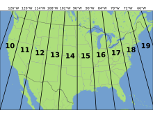
The UTM system divides the Earth into 60 north-south zones, each representing 6° of longitude. The zones are numbered, with zones 19 to 10 covering the continental United States, and zone 1 in the middle of the Pacific Ocean, near the International Date Line. Each zone has a central meridian, or north-south line that serves as an east-west refence point, and the equator which serves as the north-south reference point.

A location is defined by the distance the point is from these lines in meters. The distance from the central meridian of each zone is called the Easting, and the distance from the equator is called the Northing. For example, a location could be described as UTM Zone 18 585,000 m easting 4,515,500 m northing. You can convert UTM into Latitude and Longitude using an online converter (such as http://www.rcn.montana.edu/resources/converter.aspx), or convert Latitude and Longitude into UTM coordinates. On modern topographic maps, both UTM and Latitude and Longitude are indicated on the edges of the map, so that points can be easily located with either system. Using this knowledge, you can locate your position anywhere on Earth.
| Previous | Current | Next | |
|---|---|---|---|
|
d. How to Navigate Across Earth using a Compass, Sextant, and Timepiece. |