History of Sylhet/Brief overview of Sylhet's geographical location
Brief Overview of Sylhet's Geographical Location
[edit | edit source]Sylhet is a region located in the northeastern part of the Indian subcontinent, encompassing both modern-day Bangladesh and India. Its geographical location plays a significant role in shaping its unique landscape and climate.
-
 Grey-green orthographic projection focused on the Indian subcontinent, where all countries part of said Indian subcontinent are highlighted dark green to provide the viewer with a visual representation of where the Indian subcontinent is and what countries are part of it.
.svg)
Image credit: Jeet Dev / Wikimedia user
Geography
[edit | edit source]Sylhet is primarily characterized by its lush green hills, picturesque landscapes, and numerous water bodies. Key geographical features include:
Hills and Plateaus
[edit | edit source]The Sylhet region is renowned for its rolling hills and plateaus, making it a popular destination for nature enthusiasts and tourists. The Khasi and Jaintia Hills, part of the larger Garo-Khasi-Jaintia range, extend into Sylhet, contributing to its hilly terrain.
-
 The swamp area of Dibir Haor, in the Bangladesh-India border region at Jointapur near Sylhet.

Image credit: Abdul Momin / Wikimedia user
Rivers and Wetlands
[edit | edit source]Several major rivers, including the Surma and Kushiara rivers, flow through Sylhet. These rivers not only provide water resources but also shape the fertile plains surrounding them. The region is also dotted with wetlands and haors (seasonal floodplains), adding to its ecological diversity.
-
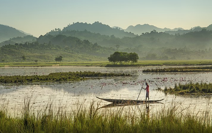
 The Ratargul Swamp Forest is the only flooded forest in Sylhet, Bangladesh and these boats are likely used to bring tourists in to view it.

Image credit: Abdulmominbd / Wikimedia user
Tea Gardens
[edit | edit source]Sylhet is famous for its tea gardens, which cover vast expanses of land. The British introduced tea cultivation in the 19th century, and Sylhet's climate and topography proved ideal for tea production. Today, Sylhet is a significant contributor to the tea industry in both Bangladesh and India.
-
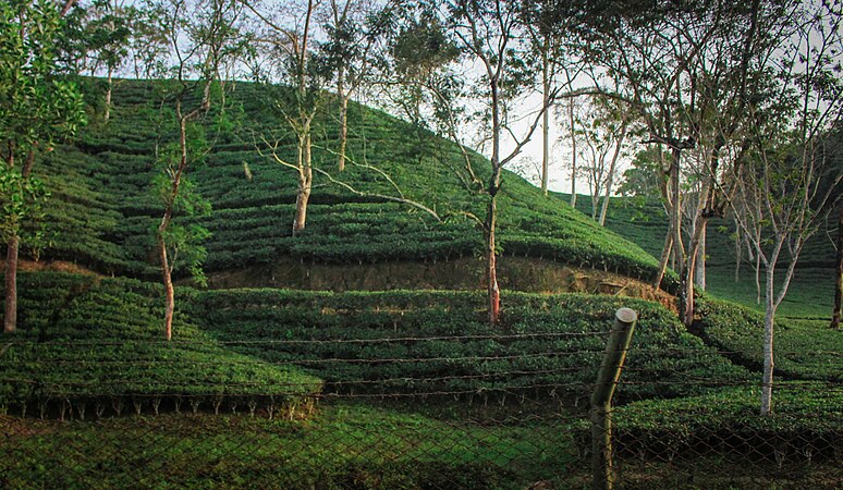 Tea garden in Sylhet.
.jpg)
Image credit: Abu Hasan Mehedi / Wikimedia user
Climate
[edit | edit source]Sylhet experiences a humid subtropical climate characterized by distinct seasons:
- Summer (March to June): Warm and humid with temperatures reaching highs.
- Monsoon (June to September): Heavy rainfall during this season is vital for agriculture.
- Autumn (October to November): Pleasant weather with cooler temperatures.
- Winter (December to February): Cool and dry, with temperatures dropping significantly.
| Month | Jan | Feb | Mar | Apr | May | Jun | Jul | Aug | Sep | Oct | Nov | Dec | Year |
|---|---|---|---|---|---|---|---|---|---|---|---|---|---|
| Average high °C (°F) | 25.2 (77.4) |
27.1 (80.8) |
30.4 (86.7) |
30.8 (87.4) |
30.8 (87.4) |
30.9 (87.6) |
30.9 (87.6) |
31.6 (88.9) |
31.2 (88.2) |
30.9 (87.6) |
29.2 (84.6) |
26.3 (79.3) |
29.6 (85.3) |
| Average low °C (°F) | 12.9 (55.2) |
14.2 (57.6) |
18.1 (64.6) |
20.8 (69.4) |
22.6 (72.7) |
24.4 (75.9) |
24.9 (76.8) |
25.0 (77.0) |
24.3 (75.7) |
22.5 (72.5) |
18.4 (65.1) |
14.0 (57.2) |
20.2 (68.3) |
| Average rainfall mm (inches) | 8 (0.3) |
31 (1.2) |
146 (5.7) |
372 (14.6) |
569 (22.4) |
796 (31.3) |
834 (32.8) |
621 (24.4) |
548 (21.6) |
232 (9.1) |
30 (1.2) |
13 (0.5) |
4,200 (165.1) |
| Source: WMO[1] | |||||||||||||
Further Reading
[edit | edit source]| This section is a stub. You can help Wikibooks by expanding it. |
For a deeper understanding of Sylhet's geographical features and its impact on the region's history and culture, you may consider exploring the following notable books:
- "Hazrat Shah Jalal O Sylheter Itihas (Shah Jalal and the History of Sylhet)" by Syed Murtaza Ali - An erudite exploration delving into the annals of Sylhet's rich historical narrative.
- "The ‘Hut’ and the ‘Axe’: The 1947 Sylhet Referendum" by Bidyut Chakrabarty - A meticulous dissection of the Sylhet division and an illuminating exposition of the British divide and rule stratagem.
- "Investing in Nature Around Sylhet: An Excursion into Geographical History" by David Ludden - A scholarly tome unveiling the bountiful natural resources that have shaped the geographical history of the region.
- "Tombs in Tea: Tea Garden Cemeteries, Sylhet, Bangladesh" by John Alfred Radford and Susan Maria Farrington - An exhaustive compendium detailing the prominent cemeteries of Kajuricherra, Chandpore, Lungla, Sylhet, Shamshernagar, Chhatak, Morapore, Dullabcherra, and Baitakhal in Sylhet.
These resources can help you delve deeper into the geographical aspects of Sylhet and their significance.
- ↑ "Climatological Information". WMO. Retrieved 23 September 2023.