High School Earth Science/Climate and Its Causes
While almost anything can happen with the weather, climate is more predictable. The weather on a particular winter day in San Diego may be colder than on the same day in Lake Tahoe, but, on average, Tahoe's winter climate is significantly colder than San Diego's. Climate then is the long-term average of weather. Good climate is why we choose to vacation in Hawaii in February, even though the weather is not guaranteed to be good!
Lesson Objectives
- Describe the effect of latitude on the solar radiation a location receives and how this influences climate.
- Diagram the Hadley, Ferrell, and Polar atmospheric circulation cells and show how they influence the climate of various locations.
- Discuss the other important location factors that influence a location's climate: position in the global wind belts, proximity to a large water body, position relative to a mountain range, and others.
What is Climate?
Weather is what is happening in the atmosphere at a particular location at the moment. Climate is the average of weather in that location over a long period of time, usually for at least 30 years. A location's climate can be described by its air temperature, humidity, wind speed and direction, and the type, quantity, and frequency of precipitation. The climate of a location depends on its position relative to many things. Most important is latitude, but other factors include global and local winds, closeness to an ocean or other large bodies of water, nearness to mountains, and altitude. Climate can change, but only over long periods of time.
The term climate also refers to Earth's entire climate system. The climate system is influenced by the movement of heat around the globe. Heat is carried by currents within the atmosphere and oceans. The type and amount of vegetation also affects climate. Plants absorb heat and retain water, which may increase or decrease rainfall. The composition of the atmosphere also controls climate. If the concentration of greenhouse gases increase or decrease, the heat-trapping abilities of the atmosphere rise or fall.
Latitude
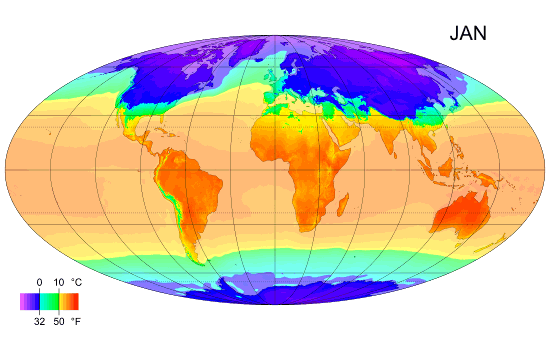
The amount of solar energy a particular location receives is the most important factor in determining that location's temperature. The amount of sunlight that strikes the ground is different at each latitude. The lower the latitude, the more sunlight an area will receive. At the equator, days are equally long year-round and the sun is just about directly overhead at midday. At the poles, during the winter, nights are long and the sun never rises very high in the sky. Sunlight filters through a thick wedge of atmosphere, making the sunlight much less intense. Ice and snow at high latitudes also reflect a good portion of the sun's light, giving these regions much greater albedo.
This animation shows the average surface temperature across the planet as it changes through the year:

From all this information you can understand why the tropics are warmer than the polar areas. The temperate regions are in between, both in latitude and average air temperature. The air in Earth's atmosphere moves as the Sun warms some areas more than others. The main reason we have different climates at various latitudes is also determined by the amount of sunlight that hits each place (Figure 17.1).

Prevailing Winds
There are winds that usually blow in one particular direction, called the global wind belts. These winds are called the trade winds, the westerlies and the polar easterlies. The direction these winds blow is different at various latitudes. In the Earth's Atmosphere chapter, you learned that air rises at low pressure areas, which form at 0° and again at 50° to 60° north and south of the equator. Air sinks at high pressure areas, which form at around 30° N and S and at the poles. These low and high pressure zones represent the upward and downward flowing regions of the Hadley, Ferrell and Polar atmospheric circulation cells (Figure 17.2). Low pressure areas form where air is moving upwards or rising. High pressure areas form where cooler, drier air sinks. Areas of high pressure often have climates that are cooler and drier. Low pressure zones often have climates that are warm and rainy.

The low pressure area near the equator is located at the boundary between the two Hadley Cells. In both these cells, air rises up at the equator and then travels away from the equator. This band of rising air is called the Intertropical Convergence Zone (ITCZ) (Figure 17.3). As the air rises, it cools and condenses to create clouds and rain. Climate along the ITCZ is therefore warm and wet. In an area where the air is mostly rising, there is not much wind. Early mariners called this region the doldrums because their ships were often unable to sail without steady winds.

The ITCZ migrates slightly with the season. Land areas heat more quickly than the oceans. Since there are more land areas in the Northern Hemisphere, the ITCZ is influenced by the heating effect of the land. In Northern Hemisphere summer, it is approximately 5° north of the equator while in the winter, it shifts back and is approximately at the equator. As the ITCZ shifts, the major wind belts also shift slightly north in summer and south in winter, which causes the wet and dry seasons in this area (Figure 17.4).

At the high pressure zone where the Hadley cell and Ferrell cells meet, at about 30°N and 30°S, the air is fairly warm since much of it came from the equator. It is also very dry for two reasons: (1) The air lost much of its moisture at the ITCZ, and (2) Sinking air is more likely to cause evaporation than precipitation. Mariners had a very grim reason for naming this region the horse latitudes. Often the lack of wind would cause their ships to be delayed for so long that they would run out of water and food for their livestock. Sailors would toss horses and other animals over the side of the ship after they died. Sailors sometimes didn't make it either. On land, these high pressure regions mark the locations of many of the world's great deserts, including the Sahara in Africa and the Sonora in North America.
The other low pressure zone is between the Ferrell and Polar Cells at around 50-60°. This is the usual location of the polar jet stream, where cold air from the poles meets warmer air from the tropics and storms are common. As the Earth orbits the Sun, the angle of the Sun shifts between 23.5°N and 23.5°S; in turn, this shift causes the polar jet stream to move. Like the ITCZ, the position of the polar jet stream moves seasonally, creating seasonal weather changes in the mid-latitudes.
The direction of the prevailing winds greatly influences the climate of a region. These winds form the bases of the Hadley, Ferrell and Polar Cells. Winds often bring the weather from the locations they come from. For example, in California, the predominant winds are the westerlies. These winds blow in from the Pacific Ocean. The stability of the ocean's temperatures moderates California temperatures, so that summers are cooler and winters are warmer. In the middle of the continent, the winds bring more variable conditions. Local winds also influence local climate. For example, land breezes and sea breezes moderate coastal temperatures.
Continental Position
When a particular location is near an ocean or large lake, the body of water plays an extremely important role in affecting the region's climate. When a location has a maritime climate its climate is strongly influenced by the nearby sea: summers are not too hot and winters are not too cold. Temperatures also do not vary much between day and night. For a location to have a true maritime climate, the winds must most frequently come off the sea. A continental climate is more extreme, with greater temperature differences between day and night and between summer and winter.
The ocean's influence in moderating climate can be seen in the following temperature comparisons. Each of these cities is located at 37°N latitude, within the westerly winds. San Francisco is on the Pacific coast; Wichita, Kansas is in the middle of the North American continent; and Virginia Beach, Virginia is on the Atlantic coast. San Francisco is cooler in July and warmer in January than either of the other two cities. This is typical of a maritime climate; not too hot, not too cold. Wichita has the greatest range of temperatures; the hottest temperatures in July and coldest in January, which is typical for a continental climate. Although Virginia Beach is located on the Atlantic Ocean, it has a mostly continental climate since the westerly winds come off the continent (Table 17.1).
| Location | City | July: high (°C/°F) | January: low (°C/°F) |
|---|---|---|---|
| West Coast | San Francisco, CA | 19/66 | 8/46 |
| Central United States | Wichita, KS | 33/92 | -7/20 |
| East Coast | Virginia Beach, VA | 32/89 | 1/31 |
Ocean Currents
The temperature of the water offshore will influence the temperature of a coastal location, particularly if the winds come off the sea. The California Current runs from north to south along the length of the western coast of North America. The cool waters of the California Current bring cooler temperatures to the California coastal region. Coastal upwelling also brings cold, deep water up to the ocean surface off of California, which contributes to the cool, coastal temperatures. Further north, in southern Alaska, the upwelling actually raises the temperature of the surrounding land because the ocean water is much warmer than the land.
The California Current is part of the global system of surface ocean currents that spread the Sun's heat around the world. These currents bring cool water from high latitudes to the low latitudes and warm water from low latitudes to the high latitudes. Just as the California current brings cooler temperatures into the temperate regions, the Gulf Stream raises air temperatures along the southeastern United States as it brings warm equatorial water north along the Western Atlantic ocean (Figure 17.5).

The Gulf Stream even has a large effect on the climate of Northern Europe. After it travels past Canada, the current moves eastward across the Atlantic and then splits. One portion flows northward between Great Britain and Northern Europe, the other moves south along Europe and northern Africa. These warm waters raise temperatures in the North Sea, which raises air temperatures over land between 3 to 6°C (5 to 11°F). London, U.K. for example, is at the same latitude as Quebec, Canada. However, London's average January temperature is 3.8°C (38°F), while Quebec's is only -12°C (10°F). Because air traveling over the warm water in the Gulf Stream picks up a lot of water, London gets a lot of rain. In contrast, Quebec is much drier and receives its precipitation as snow.
Altitude and Mountain Ranges
All else being equal, air temperature decreases at higher altitudes. A town at 3000 meters in the mountains will be much cooler, on average, than a town at the base of the same mountains. Gravity pulls air molecules closer together at sea level than at higher altitudes. The closer molecules are packed together, the more likely they are to collide. Collisions between molecules give off heat, which warms the air. At higher altitudes, the air is less dense and air molecules are more spread out and less likely to collide.
Mountain ranges have two effects on the climate of the surrounding region. One is the rainshadow effect. As moist air rises over a mountain, it cools and drops precipitation. The air then descends down the leeward side of the range. This process creates a high pressure region on the back side of the mountain where evaporation exceeds precipitation. The result is that the windward side of the mountain range is wet but the leeward side is dry. The other effect occurs when the mountain range separates the coastal region from the rest of the continent. In this case, the ocean can only influence the coastal area before the mountain range. The coastal area near the ocean will have a maritime climate but just over the mountain, the inland area will have a continental climate.
California has two mountain ranges that exhibit both effects on climate: the Coast Range right along the coast and the Sierra Nevada, further east. The predominant winds here are the westerlies, winds that blow from the west over the ocean onto the continent. Both ranges trap cool air from the Pacific so that it has a difficult time moving eastward. As this moist ocean air rises over the Coast Range, it drops a lot of rain on the windward side. A rainshadow is created as the air then descends into the Central Valley, some of which receives so little rainfall it is classified as a desert. As the air continues eastward, it rises over the Sierra Nevada Mountains and drops more rain and snow on the west side of these mountains. On the leeward side, the air then descends into Nevada. The Sierra Nevada rain shadow creates the Great Basin desert, covering Nevada, western Utah and a small part of southeastern Oregon (Figure 17.6).

Lesson Summary
- Many factors influence the climate of a region, all of them somehow related to the region's position.
- Latitude determines how much solar energy a particular place receives during a day or a year.
- Latitude is directly related to location within one of the global wind belts, therefore latitude determines if a location is beneath a high or low pressure cell, where winds are low.
- If a region is near a large water body, its climate will be influenced by that water body.
- Mountain ranges can separate land areas from the oceans and can create rainshadow effects, which also influence climate.
Review Questions
- Describe the weather of the location where you are right now. How is the weather today typical or atypical of your usual climate?
- In what two ways could a desert be found at 30°N?
- Could a desert form at 45°N latitude?
- Why is there so little wind in the locations where the atmospheric circulation cells meet?
- If it is windy at 30°N where there is normally little wind, does that mean the model of the atmospheric circulation cells is wrong?
- What is the Intertropical Convergence Zone (ITCZ)? What winds do you expect to find here?
- How does the polar jet stream move from summer to winter? How would this affect the climate of the locations where it moves?
- How would the climate of a city at 45°N near the Pacific Ocean differ from one at the same latitude near the Atlantic Coast?
- Why does the ocean water off California cool the western portion of the state, while the water off the southeastern United States warms that region?
- Think about what you know about surface ocean currents. How would you expect the climate of western South America to be influenced by the Pacific Ocean? Could this same effect happen in the Northern Hemisphere?
- The Andes Mountains line western South America. How do you think they influence the climate of that region and the lands to the east of them?
Vocabulary
- climate
- Weather averaged over a long period of time, usually about 30 years.
- continental climate
- A location in which the climate is dominated by a vast expanse of land. Continental climates are more variable.
- Intertropical Convergence Zone (ITCZ)
- A low pressure zone where the Hadley Cells in the northern and southern hemispheres meet. The trade winds meet at the ITCZ.
- maritime climate
- A location in which the climate is dominated by a nearby ocean. Maritime climates are less variable than continental climates.
- rainshadow
- Dry conditions that are created on the leeward side of a mountain range.
- upwelling
- Upward flow of deep water to the surface because the deep water is less dense than the surface water.
Points to Consider
- Describe how two cities at the same latitude can have very different climates. For example, Tucson, Arizona has a hot, dry desert climate and New Orleans, Louisiana has a warm, muggy climate even though both cities are at approximately the same latitude.
- How does climate influence the plants and animals that live in a particular place?
- Would you expect climate at similar latitudes to be the same or different on the opposite side of the equator, e.g. how would the climate of a city at 45°N be similar or different to one at 45°S latitude?