File:Schlieffen Plan de 1905.svg
Jump to navigation
Jump to search

Size of this PNG preview of this SVG file: 773 × 599 pixels. Other resolutions: 310 × 240 pixels | 619 × 480 pixels | 991 × 768 pixels | 1,280 × 993 pixels | 2,560 × 1,985 pixels | 962 × 746 pixels.
Original file (SVG file, nominally 962 × 746 pixels, file size: 1.36 MB)
|
|
This is a file from the Wikimedia Commons |
Summary
| Description |
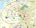
Deutsch: Der Schlieffen-Plan aus dem Jahr 1905.
Français : « Plan Schlieffen » : plan de déploiement allemand du printemps 1905 et axes d'offensive correspondant au scénario Kuhl de l'été 1905 ainsi qu'au mémoire de décembre 1905. English: Map of the Schlieffen Plan of 1905. |
| Date | (UTC) |
| Source |
This file was derived from: Schlieffen Plan fr 1905.svg: |
| Author |
|
| This is a retouched picture, which means that it has been digitally altered from its original version. Modifications: traduction allemand. The original can be viewed here: Schlieffen Plan fr 1905.svg:
|
Gallery
-
 french
 -
 magyar


Licensing
I, the copyright holder of this work, hereby publish it under the following licenses:
This file is licensed under the Creative Commons Attribution-Share Alike 3.0 Unported, 2.5 Generic, 2.0 Generic and 1.0 Generic license.
- You are free:
- to share – to copy, distribute and transmit the work
- to remix – to adapt the work
- Under the following conditions:
- attribution – You must give appropriate credit, provide a link to the license, and indicate if changes were made. You may do so in any reasonable manner, but not in any way that suggests the licensor endorses you or your use.
- share alike – If you remix, transform, or build upon the material, you must distribute your contributions under the same or compatible license as the original.

|
Permission is granted to copy, distribute and/or modify this document under the terms of the GNU Free Documentation License, Version 1.2 or any later version published by the Free Software Foundation; with no Invariant Sections, no Front-Cover Texts, and no Back-Cover Texts. A copy of the license is included in the section entitled GNU Free Documentation License. |
You may select the license of your choice.
Original upload log
This image is a derivative work of the following images:
- File:Schlieffen_Plan_fr_1905.svg licensed with Cc-by-sa-3.0,2.5,2.0,1.0, GFDL
- 2013-10-22T06:58:45Z Lvcvlvs 1200x930 (1452417 Bytes) Correction d'un toponyme, modification des noms d'armée et de la légende.
- 2013-10-20T17:06:27Z Lvcvlvs 1200x930 (1455822 Bytes) Correction de quelques toponymes et rectification de la position de la Forêt-Noire.
- 2013-10-19T17:18:48Z Lvcvlvs 1200x930 (1517869 Bytes) résolution de petits pb graphiques sur les cadres des noms d'armée ; fortifications allemandes sur le Rhin en aval de l'Alsace.
- 2013-10-19T16:25:34Z Lvcvlvs 1200x930 (1516419 Bytes) {{Information |Description ={{fr|1=« [[w:fr:Plan Schlieffen|Plan Schlieffen]] » : plan de déploiement allemand du printemps 1905 et axes d'offensive correspondant au scénario Kuhl de l'été 1905 ainsi qu'au mémoire d
Uploaded with derivativeFX
File history
Click on a date/time to view the file as it appeared at that time.
| Date/Time | Thumbnail | Dimensions | User | Comment | |
|---|---|---|---|---|---|
| current | 11:01, 27 June 2015 | | 962 × 746 (1.36 MB) | Erik del Toro Streb | Windrose wieder hergestellt, Armeebeschriftungen vereinheitlicht und über Fluss angehoben (2. Armee) |
| 14:59, 9 November 2013 |  | 962 × 746 (1.21 MB) | Furfur | == {{int:filedesc}} == {{Information |Description={{de|1=Der Schlieffen-Plan aus dem Jahr 1905.}} {{fr|1=« Plan Schlieffen » : plan de déploiement allemand du printemps 1905 et axes d'offensive corres... |
File usage
The following page uses this file:
Global file usage
The following other wikis use this file:
- Usage on de.wikipedia.org
- Usage on es.wikipedia.org
- Usage on fr.wikipedia.org
- Usage on fy.wikipedia.org
- Usage on ga.wikipedia.org
- Usage on hu.wikipedia.org
- Usage on oc.wikipedia.org
- Usage on ro.wikipedia.org
- Usage on uk.wikipedia.org
- Usage on vi.wikipedia.org