File:Map of Argentina with provinces.svg

Original file (SVG file, nominally 568 × 937 pixels, file size: 466 KB)
|
|
This is a file from the Wikimedia Commons |
Summary
| Description |
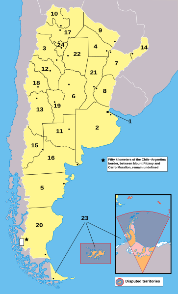
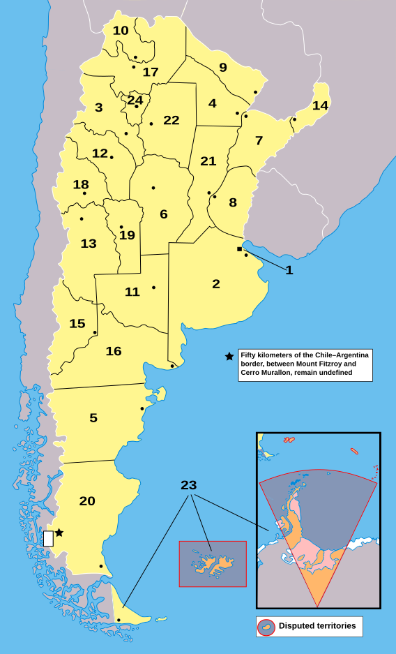
English: Map of Argentina with provinces. Provinces are numbered according to Argentina#Provinces
Català: Mapa de les províncies de l'Argentina. Els territoris en taronja no estan sota sobirania argentina: estan sota sobirania del Regne Unit (per exemple, les Illes de l'Atlàntic Sud) o és una reivindicació pendent (per exemple, l'Antàrtida).
1: Ciutat Autònoma de Buenos Aires 2: Província de Buenos Aires 3: Catamarca 4: Chaco 5: Chubut 6: Córdoba 7: Corrientes 8: Entre Ríos 9: Formosa 10: Jujuy 11: La Pampa 12: La Rioja 13: Mendoza 14: Misiones 15: Neuquén 16: Rio Negro 17: Salta 18: San Juan 19: San Luis 20: Santa Cruz 21: Santa Fe 22: Santiago del Estero 23: Terra del Foc, Antàrtida i Illes de l'Atlàntic Sud 24: Tucumán |
| Source | My own work based on public domain File:Argentina_-_Político_2.png. |
| Author | Lo2u (T • C) |
| Other versions |
|
| SVG development |


Licensing
| I, the copyright holder of this work, release this work into the public domain. This applies worldwide. In some countries this may not be legally possible; if so: I grant anyone the right to use this work for any purpose, without any conditions, unless such conditions are required by law. |
File history
Click on a date/time to view the file as it appeared at that time.
| Date/Time | Thumbnail | Dimensions | User | Comment | |
|---|---|---|---|---|---|
| current | 09:39, 17 September 2023 | | 568 × 937 (466 KB) | Editantpv | File uploaded using svgtranslate tool (https://svgtranslate.toolforge.org/). Added translation for ca. |
| 00:28, 24 October 2008 |  | 568 × 937 (467 KB) | Lo2u | (({{Information |Description=Map of Argentina |Source=My own work based on public domain Image:Argentina - Político 2.png. |Date= |Author=Lo2u <sup>(T • C)</sup> |other_versions=Image:Argentina_-_Pol%C3%ADtico_2.png }})) | |
| 00:22, 24 October 2008 |  | 568 × 937 (467 KB) | Lo2u | ({{Information |Description=Map of Argentina |Source=My own work based on public domain Image:Argentina - Político 2.png. |Date= |Author=Lo2u <sup>(T • C)</sup> |other_versions=Image:Argentina_-_Pol%C3%ADtico_2.png }}) | |
| 22:26, 22 October 2008 |  | 568 × 937 (468 KB) | Lo2u | {{Information |Description=Map of Argentina |Source=My own work based on public domain Image:Argentina - Político 2.png. |Date= |Author=Lo2u <sup>(T • C)</sup> |other_versions=Image:Argent | |
| 22:20, 22 October 2008 |  | 568 × 937 (468 KB) | Lo2u | {{Information |Description=Map of Argentina |Source=My own work based on public domain Image:Argentina - Político 2.png. |Date= |Author=Lo2u <sup>(T • C)</sup> |other_versions=Image:Argent | |
| 20:30, 22 October 2008 |  | 568 × 937 (562 KB) | Lo2u | {{Information |Description= |Source=My own work based on public domain Image:Argentina - Político 2.png. |Date= |Author=~~~ |other_versions=Image:Argentina_-_Pol%C3%ADtico_2.png }} |
File usage
The following page uses this file:
Global file usage
The following other wikis use this file:
- Usage on bn.wikibooks.org
- Usage on bo.wikipedia.org
- Usage on br.wikipedia.org
- Usage on ca.wikipedia.org
- Usage on es.wikipedia.org
- Usage on fur.wikipedia.org
- Usage on fy.wikipedia.org
- Usage on he.wikipedia.org
- Usage on id.wikibooks.org
- Usage on ja.wikipedia.org
- Usage on la.wikipedia.org
- Usage on ru.wikipedia.org
- Usage on tr.wikipedia.org
- Usage on zh.wikibooks.org