File:Ferry light trail, Rostock.jpg
Jump to navigation
Jump to search

Size of this preview: 800 × 450 pixels. Other resolutions: 320 × 180 pixels | 640 × 360 pixels | 1,024 × 576 pixels | 1,280 × 720 pixels | 2,560 × 1,440 pixels | 4,000 × 2,250 pixels.
Original file (4,000 × 2,250 pixels, file size: 7.76 MB, MIME type: image/jpeg)
|
|
This is a file from the Wikimedia Commons |
Summary
| Description |
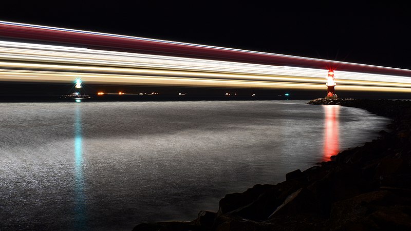
English: Light trail of the largest German ferry M/S Mecklenburg-Vorpommern on its way from Rostock to Trelleborg: Aperture f/20, Exposure time 219 seconds
العربية: مسار أضواء أكبر عبارة ألمانية في وانيموند في ألمانيا
বাংলা: বৃহত্তম জার্মান ফেরি এম/এস মেকলেনবার্গ-ভোর্পোমারনের বাতির চিহ্নরেখা। বার্নামুন্ডে, জার্মানি।
Bosanski: Svjetlosni trag najvećeg njemačkog trajekta M/S Mecklenburg-Vorpommern u Warnemündeu, Njemačka
Čeština: Světelná stopa největšího německého trajektu M/S Mecklenburg-Vorpommern v přístavu města Warnemünde u Baltského moře
Deutsch: Lichtspur der größten deutschen Fähre M/S Mecklenburg-Vorpommern auf dem Weg von Rostock nach Trelleborg: Blende f/20, Belichtungszeit 219 Sekunden
Español: Sendero de luz del transbordador alemán M/S Mecklenburg-Vorpommern en Warnemünde, Alemania: Apertura f/20, Velocidad de obturación 219 segundos
Esperanto: Luma spuro de la plej granda germana pramo "M/S Meklenburgo-Antaŭpomerio" en Warnemünde, Germanio
Français : Les traces lumineuses du Mecklenburg-Vorpommern, l'un des plus larges ferries allemands, à Warnemünde
Magyar: A legnagyobb német kompnak, az MS Mecklenburg-Vorpommernnek a fénycsíkja (Warnemünde, Németország)
Nederlands: Lichtspoor van de spoorpont Mecklenburg-Vorpommern, de grootste Duitse veerboot, onderweg van Rostock naar Trelleborg
Polski: Ślad światła największego niemieckiego promu M/S Mecklenburg-Vorpommern wypływającego z Rostocku do Trelleborga: Apertura f/20, Czas naświetlania 219 sekund
Português: Rastro de luz da maior balsa alemã, M/S Mecklenburg-Vorpommern, em Warnemünde, Alemanha
Українська: Світловий слід від найбільшого німецького порому M/S Мекленбург-Передня Померанія на шляху від Ростока до Треллеборга: Діафрагма f/20, час витримки 219 секунд |
| Date | Taken on 2 January 2021, 22:12:18 |
| Source | Own work |
| Author | Radomianin |
| Other versions |
|

| Camera location | | View this and other nearby images on: OpenStreetMap |
|---|
| Attribution (required by the license) | © Radomianin / Wikimedia Commons / CC BY-SA 4.0 |
| Using this image | You can use this image file free of charge under the terms of the free license CC BY-SA 4.0. In particular, this means:
|
| Editing this image |
|
The photo was taken from the east mole in the district Hohe Düne, view from southeast.
Assessment
|
This image was selected as picture of the day on Wikimedia Commons for 20 May 2021. It was captioned as follows: Other languages:
Bosanski: Svjetlosni trag najvećeg njemačkog trajekta M/S Mecklenburg-Vorpommern u Warnemündeu, Njemačka Čeština: Světelná stopa největšího německého trajektu M/S Mecklenburg-Vorpommern v přístavu města Warnemünde u Baltského moře Esperanto: Luma spuro de la plej granda germana pramo "M/S Meklenburgo-Antaŭpomerio" en Warnemünde, Germanio Français : Les traces lumineuses du Mecklenburg-Vorpommern, l'un des plus larges ferries allemands, à Warnemünde Magyar: A legnagyobb német kompnak, az MS Mecklenburg-Vorpommernnek a fénycsíkja (Warnemünde, Németország) Nederlands: Lichtspoor van de spoorpont Mecklenburg-Vorpommern, de grootste Duitse veerboot, onderweg van Rostock naar Trelleborg Polski: Ślad światła największego niemieckiego promu M/S Mecklenburg-Vorpommern w Warnemünde, Niemcy Português: Rastro de luz da maior balsa alemã, M/S Mecklenburg-Vorpommern, em Warnemünde, Alemanha Українська: Світловий слід від найбільшого німецького порому M/S Мекленбург-Передня Померанія у Варнемюнде, Німеччина বাংলা : বৃহত্তম জার্মান ফেরি এম/এস মেকলেনবার্গ-ভোর্পোমারনের বাতির চিহ্নরেখা। বার্নামুন্ডে, জার্মানি। العربية : مسار أضواء أكبر عبارة ألمانية في وانيموند في ألمانيا. |
Licensing
I, the copyright holder of this work, hereby publish it under the following license:
This file is licensed under the Creative Commons Attribution-Share Alike 4.0 International license.
- You are free:
- to share – to copy, distribute and transmit the work
- to remix – to adapt the work
- Under the following conditions:
- attribution – You must give appropriate credit, provide a link to the license, and indicate if changes were made. You may do so in any reasonable manner, but not in any way that suggests the licensor endorses you or your use.
- share alike – If you remix, transform, or build upon the material, you must distribute your contributions under the same or compatible license as the original.
File history
Click on a date/time to view the file as it appeared at that time.
| Date/Time | Thumbnail | Dimensions | User | Comment | |
|---|---|---|---|---|---|
| current | 12:14, 20 February 2021 | | 4,000 × 2,250 (7.76 MB) | Radomianin | image cropping changed |
| 14:35, 17 February 2021 |  | 4,047 × 2,277 (7.21 MB) | Radomianin | Uploaded own work with UploadWizard |
File usage
There are no pages that use this file.
Global file usage
The following other wikis use this file:
- Usage on alt.wikipedia.org
- Usage on av.wikipedia.org
- Usage on be-tarask.wikipedia.org
- Usage on bn.wikipedia.org
- Usage on crh.wikipedia.org
- Usage on cv.wikipedia.org
- Usage on fr.wikipedia.org
- Usage on hu.wikipedia.org
- Usage on hy.wikipedia.org
- Usage on ka.wikipedia.org
- Usage on ko.wikipedia.org
- Usage on lbe.wikipedia.org
- Usage on lez.wikipedia.org
- Usage on mk.wikipedia.org
- Usage on os.wikipedia.org
- Usage on pl.wikipedia.org
- Usage on pt.wikipedia.org
- Usage on ru.wikipedia.org
- Usage on ru.wikinews.org
- Usage on sah.wikipedia.org
- Usage on uk.wikipedia.org
- Usage on vep.wikipedia.org
- Usage on zh.wikipedia.org