File:Colonial Africa 1913 map.svg
Jump to navigation
Jump to search

Size of this PNG preview of this SVG file: 644 × 600 pixels. Other resolutions: 258 × 240 pixels | 515 × 480 pixels | 824 × 768 pixels | 1,099 × 1,024 pixels | 2,198 × 2,048 pixels | 1,390 × 1,295 pixels.
Original file (SVG file, nominally 1,390 × 1,295 pixels, file size: 660 KB)
|
|
This is a file from the Wikimedia Commons |
BEL
|
GER
|
ESP
|
FRA
|
GBR
|
ITA
|
PRT
|
Independent
| |
|---|---|---|---|---|---|---|---|---|
العربية: |
بلجيكا | ألمانيا | اسبانيا | فرنسا | بريطانيا | إيطاليا | البرتغال | |
Azərbaycanca: |
Belçika | Almaniya | İspaniya | Fransa | Böyük Britaniya | İtaliya | Portuqaliya | |
Беларуская: |
Бельгія | Германія | Іспанія | Францыя | Вялікабрытанія | Італія | Партугалія | |
Български: |
Белгия | Германия | Испания | Франция | Великобритания | Италия | Португалия | |
বাংলা: |
বেলজিয়াম | জার্মানি | স্পেন | ফ্রান্স | যুক্তরাজ্য | ইতালি | পর্তুগাল | |
Català: |
Bèlgica | Alemanya | Espanya | França | Gran Bretanya | Itàlia | Portugal | |
Čeština: |
Belgie | Německo | Španělsko | Francie | Velká Británie | Itálie | Portugalsko | |
Cymraeg: |
Gwlad Belg | Yr Almaen | Sbaen | Ffrainc | Prydain Fawr | Yr Eidal | Portiwgal | |
Dansk: |
Belgien | Tyskland | Spanien | Frankrig | Storbritannien | Italien | Portugal | |
Deutsch: |
Belgien | Deutschland | Spanien | Frankreich | Großbritannien | Italien | Portugal | Unabhängige Staaten |
Ελληνικά: |
Βέλγιο | Γερμανία | Ισπανία | Γαλλία | Μεγάλη Βρετανία | Ιταλία | Πορτογαλία | |
English: |
Belgium | Germany | Spain | France | United Kingdom | Italy | Portugal | Independent States |
Esperanto: |
Belgio | Germanio | Hispanio | Francio | Britio | Italio | Portugalio | |
Español: |
Bélgica | Alemania | España | Francia | Gran Bretaña | Italia | Portugal | Estados independientes |
Eesti: |
Belgia | Saksamaa | Hispaania | Prantsusmaa | Suurbritannia | Itaalia | Portugal | |
Euskara: |
Belgika | Alemania | Espainia | Frantzia | Britainia Handia | Italia | Portugal | |
Suomi: |
Belgia | Saksa | Espanja | Ranska | Iso-Britannia | Italia | Portugalia | |
Français : |
Belgique | Allemagne | Espagne | France | Grande-Bretagne | Italie | Portugal | États indépendants |
Gaeilge: |
An Bheilg | An Ghearmáin | An Spáinn | An Fhrainc | An Ríocht Aontaithe | An Iodáil | An Phortáingeil | |
Galego: |
Bélxica | Alemaña | España | Francia | Gran Bretaña | Italia | Portugal | |
Hrvatski: |
Belgija | Njemačka | Španjolska | Francuska | Velika Britanija | Italija | Portugal | |
Magyar: |
Belgium | Németország | Spanyolország | Franciország | Nagy-Britania | Olaszország | Portugália | |
Հայերեն: |
Բելգիա | Գերմանիա | Իսպանիա | Ֆրանսիա | Միացյալ Թագավորություն | Իտալիա | Պորտուգալիա | |
Bahasa Indonesia: |
Belgia | Jerman | Spanyol | Prancis | Britania Raya | Ítalia | Portugal | Negara independen |
Íslenska: |
Belgía | Þýskaland | Spánn | Frakkland | Stóra Bretland | Ítalía | Portúgal | |
Italiano: |
Belgio | Germania | Spagna | Francia | Regno Unito | Italia | Portogallo | |
ქართული: |
ბელგია | გერმანია | ესპანეთი | საფრანგეთი | გაერთიანებული სამეფო | იტალია | პორტუგალია | |
한국어: |
벨기에 | 독일 | 스페인 | 프랑스 | 영국 | 이탈리아 | 포르투갈 | |
Lietuvių: |
Belgija | Vokietija | Ispanija | Prancūzija | D. Britanija | Italija | Portugalija | |
Latviešu: |
Beļģija | Vācija | Spānija | Francija | Lielbritānija | Itālija | Portugāle | |
Македонски: |
Белгија | Германија | Шпанија | Франција | Велика Британија | Италија | Португалија | |
Malti: |
Belġju | Ġermanja | Spanja | Franza | Gran Brittanja | Italja | Portugall | |
Nederlands: |
België | Duitsland | Spanje | Frankrijk | Groot-Brittannië | Italië | Portugal | Onafhankelijke gebieden |
Norsk bokmål: |
Belgia | Tyskland | Spania | Frankrike | Storbritannia | Italia | Portugal | |
Polski: |
Belgia | Niemcy | Hiszpania | Francja | Wielka Brytania | Włochy | Portugalia | |
Português: |
Bélgica | Alemanha | Espanha | França | Grã-Bretanha | Itália | Portugal | Estados independentes |
Română: |
Belgia | Germania | Spania | Franţa | Regatul Unit | Italia | Portugalia | |
Русский: |
Бельгия | Германия | Испания | Франция | Великобритания | Италия | Португалия | |
Slovenčina: |
Belgicko | Nemecko | Španielsko | Francúzsko | Veľká Británia | Taliansko | Portugalsko | |
Slovenščina: |
Belgija | Nemčija | Španija | Francija | Velika Britanija | Italija | Portugalska | |
Shqip: |
Belgjika | Gjermanija | Spanja | Franca | Britanisë së Madhe | Italia | Portugalia | |
Српски / srpski: |
Белгија | Немачка | Шпанија | Француска | Велика Британија | Италија | Португалија | |
Svenska: |
Belgien | Tyskland | Spanien | Frankrike | Storbritannien | Italien | Portugal | |
Kiswahili: |
Ubelgiji | Ujerumani | Hispania | Ufaransa | Ufalme wa Muungano | Italia | Ureno | |
Türkçe: |
Belçika | Almanya | İspanya | Fransa | Büyük Britanya | İtalya | Portekiz | |
Українська: |
Бельгія | Німеччина | Іспанія | Франція | Велика Британія | Італія | Португалія | |
Tiếng Việt: |
Bỉ | Đức | Tây Ban Nha | Pháp | Anh | Ý | Bồ Đào Nha | |
中文: |
比利时 | 德国 | 西班牙 | 法国 | 英国 | 意大利 | 葡萄牙 |
Summary
| Description |
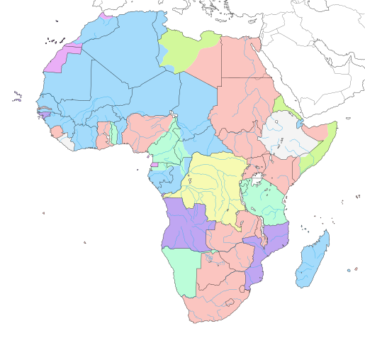
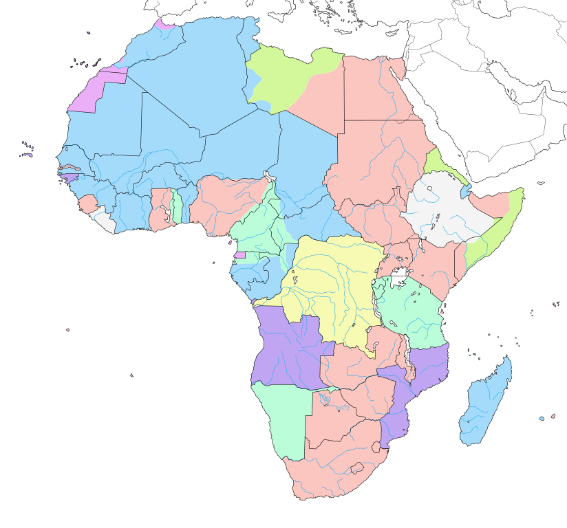
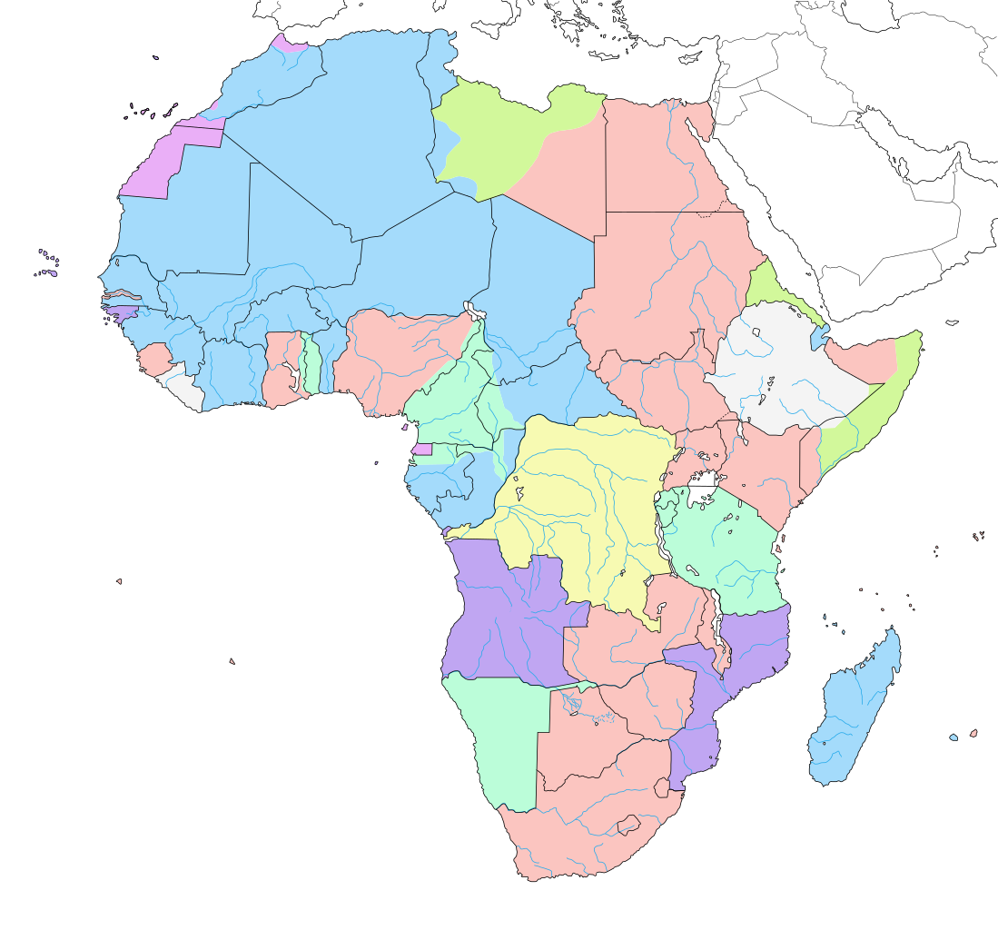
English: Map of colonial Africa as in 1913, with modern borders.
Note: The limits of the areas of control may not be perfectly accurate due to the imprecision of the reference maps. Deutsch: Karte des kolonialen Afrikas von 1913 mit modernen Grenzen.
Notiz: Die Grenzen der Kontrollbereiche sind aufgrund der Ungenauigkeit der Referenzkarten möglicherweise nicht ganz genau. Italiano: Mappa dell'Africa coloniale come nel 1913, con confini moderni.
Nota: I limiti delle aree di controllo potrebbero non essere perfettamente precisi a causa dell'imprecisione delle mappe di riferimento. Español: Mapa del África colonial como en 1913, con fronteras modernas.
Nota: Los límites de las áreas de control pueden no ser perfectamente precisos debido a la imprecisión de los mapas de referencia. Français : Carte de l'Afrique coloniale en 1913, avec frontières modernes. Note : Les limites des zones de contrôle peuvent ne pas être tout à fait exactes en raison de l'imprécision des cartes de référence utilisées. |
||
| Date | June 2007, updated/corrected 2011-07 | ||
| Source |
Own work (Original text: Own work ;)
|
||
| Author | Eric Gaba (Sting - fr:Sting) | ||
| Permission (Reusing this file) |
|
||
| Other versions |
[]
|
||
| SVG development |


.svg)

_ast.svg)


-es.svg)
_mapa.png)

_eu.svg)


.svg)

.jpg)


-sr.png)


.svg)

.svg)

Licensing
Eric Gaba, the copyright holder of this work, hereby publishes it under the following licenses:

|
Permission is granted to copy, distribute and/or modify this document under the terms of the GNU Free Documentation License, Version 1.2 or any later version published by the Free Software Foundation; with no Invariant Sections, no Front-Cover Texts, and no Back-Cover Texts. A copy of the license is included in the section entitled GNU Free Documentation License. |
| This file is licensed under the Creative Commons Attribution-Share Alike 3.0 Unported license. | ||
| Attribution: Eric Gaba – Wikimedia Commons user: Sting | ||
| ||
| This licensing tag was added to this file as part of the GFDL licensing update. |
This file is licensed under the Creative Commons Attribution-Share Alike 2.5 Generic license.
Attribution: Eric Gaba – Wikimedia Commons user: Sting
- You are free:
- to share – to copy, distribute and transmit the work
- to remix – to adapt the work
- Under the following conditions:
- attribution – You must give appropriate credit, provide a link to the license, and indicate if changes were made. You may do so in any reasonable manner, but not in any way that suggests the licensor endorses you or your use.
- share alike – If you remix, transform, or build upon the material, you must distribute your contributions under the same or compatible license as the original.
You may select the license of your choice.
File history
Click on a date/time to view the file as it appeared at that time.
| Date/Time | Thumbnail | Dimensions | User | Comment | |
|---|---|---|---|---|---|
| current | 14:29, 24 April 2019 | | 1,390 × 1,295 (660 KB) | Sting | Added surrounding landmasses ; waterbodies in white ; colour adjustment |
| 13:29, 5 July 2018 |  | 1,390 × 1,295 (586 KB) | M3tainfo | Black borders with stroke width and removed local file refs | |
| 00:36, 3 March 2014 |  | 1,390 × 1,295 (587 KB) | Sting | Reverted to version as of 13:06, 19 December 2013 | |
| 16:07, 2 March 2014 |  | 1,390 × 1,295 (590 KB) | Knyaz-1988 | New version | |
| 16:05, 2 March 2014 |  | 1,390 × 1,295 (587 KB) | Knyaz-1988 | New version | |
| 16:02, 2 March 2014 |  | 1,390 × 1,295 (587 KB) | Knyaz-1988 | New version | |
| 13:06, 19 December 2013 |  | 1,390 × 1,295 (587 KB) | Sting | Correction : Fernando Pó/Bioko under Spanish domination | |
| 21:27, 14 July 2011 |  | 1,390 × 1,295 (587 KB) | Sting | Sudan/South Sudan 2011-07 border update ; correction on the area of Cape Juby | |
| 07:23, 7 June 2007 |  | 1,390 × 1,295 (642 KB) | Sting | Colour correction | |
| 06:52, 7 June 2007 |  | 1,390 × 1,295 (642 KB) | Sting | Background |
File usage
The following 6 pages use this file:
- Issues in Interdisciplinarity 2018-19/Imperial Influences on African Education Systems
- Issues in Interdisciplinarity 2018-19/Printable version
- Issues in Interdisciplinarity 2020-21/Evidence in the Resource Curse and democratic instability in Africa
- Issues in Interdisciplinarity 2020-21/Printable version
- World History/The Age of Imperialism, Part II
- User:JREverest/sandbox/Approaches to Knowledge/Seminar group 5/Imperialism
Global file usage
The following other wikis use this file:
- Usage on af.wikipedia.org
- Usage on als.wikipedia.org
- Usage on an.wikipedia.org
- Usage on ar.wikipedia.org
- Usage on ast.wikipedia.org
- Usage on av.wikipedia.org
- Usage on az.wikipedia.org
- Usage on ba.wikipedia.org
- Usage on bg.wikipedia.org
- Usage on br.wikipedia.org
- Usage on ca.wikipedia.org
- Usage on ca.wikibooks.org
- Usage on cs.wikipedia.org
- Usage on da.wikipedia.org
- Usage on de.wikipedia.org
- Usage on diq.wikipedia.org
- Usage on el.wikipedia.org
- Usage on en.wikipedia.org
View more global usage of this file.