File:Map of proposed Suburban Rail Loop.png
Jump to navigation
Jump to search
Size of this preview: 800 × 540 pixels. Other resolutions: 320 × 216 pixels | 640 × 432 pixels | 1,024 × 691 pixels | 1,280 × 864 pixels | 2,000 × 1,350 pixels.
Original file (2,000 × 1,350 pixels, file size: 341 KB, MIME type: image/png)
|
|
This is a file from the Wikimedia Commons |
Summary
| Description |
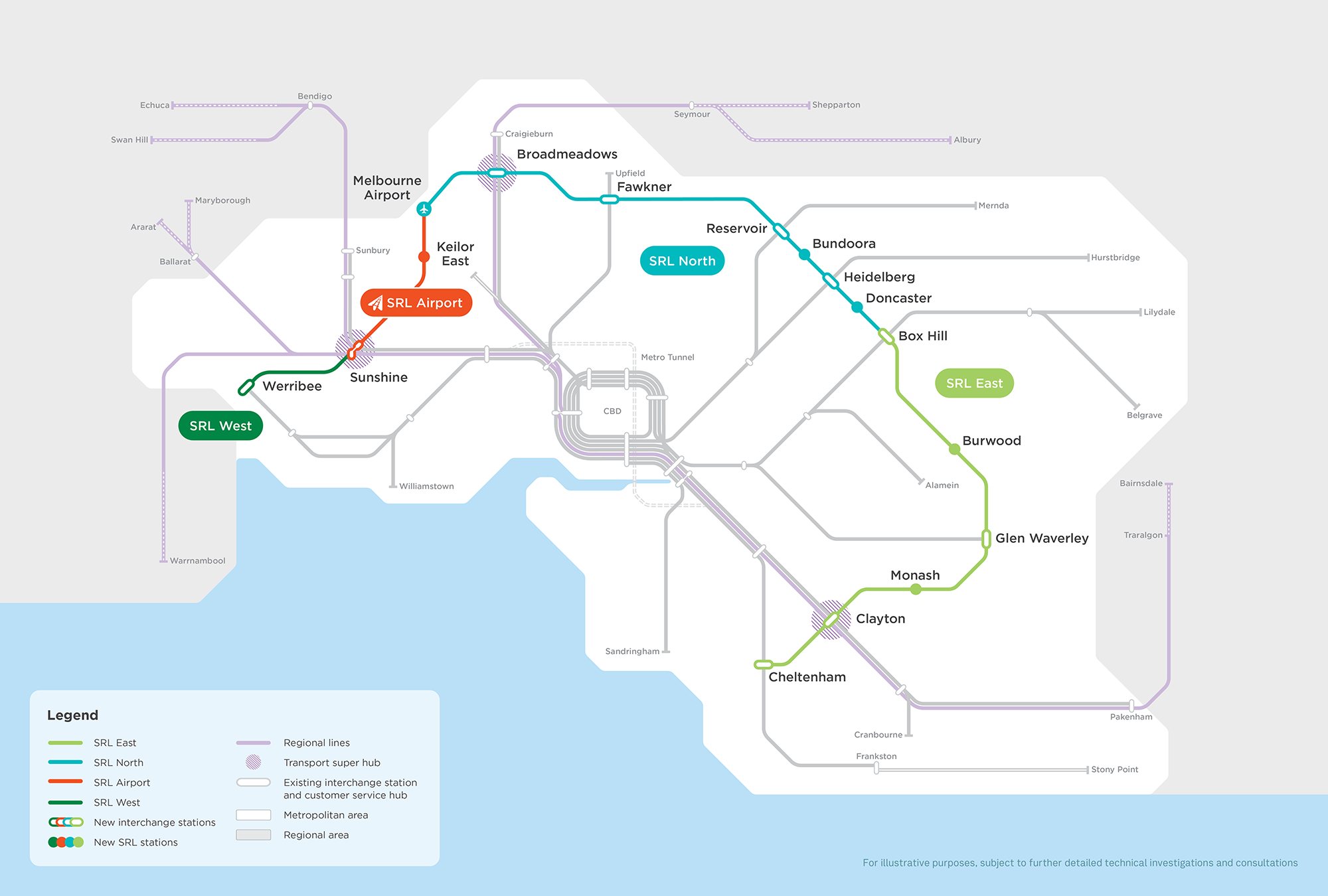
English: A map of the proposed Suburban Rail Loop. |
| Date | 25 November 2021 (access date) |
| Source | https://bigbuild.vic.gov.au/projects/suburban-rail-loop (archived link) (copyright information) |
| Author | State of Victoria (Major Transport Infrastructure Authority) |
Licensing
This file is licensed under the Creative Commons Attribution 4.0 International license.
- You are free:
- to share – to copy, distribute and transmit the work
- to remix – to adapt the work
- Under the following conditions:
- attribution – You must give appropriate credit, provide a link to the license, and indicate if changes were made. You may do so in any reasonable manner, but not in any way that suggests the licensor endorses you or your use.
File history
Click on a date/time to view the file as it appeared at that time.
| Date/Time | Thumbnail | Dimensions | User | Comment | |
|---|---|---|---|---|---|
| current | 05:54, 30 October 2022 | | 2,000 × 1,350 (341 KB) | Purin128AL | SRL airport |
| 01:41, 25 November 2021 |  | 1,280 × 853 (209 KB) | LivelyRatification | Uploaded a work by State of Victoria (Major Transport Infrastructure Authority) from https://bigbuild.vic.gov.au/projects/suburban-rail-loop (http://web.archive.org/web/20211121164433/https://bigbuild.vic.gov.au/projects/suburban-rail-loop archived link]) ([http://web.archive.org/web/20211125013636/https://bigbuild.vic.gov.au/terms-of-use copyright information]) with UploadWizard |
File usage
The following 2 pages use this file:
Global file usage
The following other wikis use this file:
- Usage on en.wikipedia.org
- Usage on es.wikipedia.org