File:Location Kilauea.svg
Jump to navigation
Jump to search

Size of this PNG preview of this SVG file: 279 × 299 pixels. Other resolutions: 224 × 240 pixels | 448 × 480 pixels | 717 × 768 pixels | 955 × 1,024 pixels | 1,911 × 2,048 pixels.
Original file (SVG file, nominally 279 × 299 pixels, file size: 94 KB)
|
|
This is a file from the Wikimedia Commons |
| Description |
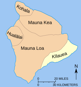
English: Map showing relationship of Kīlauea to other volcanoes that form the island of Hawai’i—‘’the Big Island. |
| Date | (UTC) |
| Source | |
| Author |
|
| Other versions |
|


This image is in the public domain in the United States because it only contains materials that originally came from the United States Geological Survey, an agency of the United States Department of the Interior. For more information, see the official USGS copyright policy.
|
File history
Click on a date/time to view the file as it appeared at that time.
| Date/Time | Thumbnail | Dimensions | User | Comment | |
|---|---|---|---|---|---|
| current | 17:07, 10 July 2010 | | 279 × 299 (94 KB) | Malus Catulus | {{Information |Description= |Source= |Date= |Author= |Permission= |other_versions= }} {{self|PD-USGov-USGS}} |
File usage
The following page uses this file:
Global file usage
The following other wikis use this file:
- Usage on ar.wikipedia.org
- Usage on ca.wikipedia.org
- Usage on de.wikipedia.org
- Usage on en.wikipedia.org
- Usage on es.wikipedia.org
- Usage on fi.wikipedia.org
- Usage on fr.wikipedia.org
- Usage on he.wikipedia.org
- Usage on ja.wikipedia.org
- Usage on ko.wikipedia.org
- Usage on mk.wikipedia.org
- Usage on no.wikipedia.org
- Usage on pl.wikipedia.org
- Usage on www.wikidata.org
- Usage on zh.wikipedia.org