
File:Hurricane Gustav - Envisat.jpg

Size of this preview: 770 × 600 pixels. Other resolutions: 308 × 240 pixels | 616 × 480 pixels | 986 × 768 pixels | 1,280 × 997 pixels | 1,755 × 1,367 pixels.
Original file (1,755 × 1,367 pixels, file size: 913 KB, MIME type: image/jpeg)
|
|
This is a file from the Wikimedia Commons |
Summary
| Hurricane Gustav | |
|---|---|
| Photographer |
Envisat satellite |
| Title |
Hurricane Gustav |
| Description |
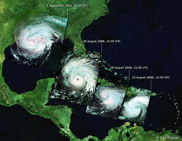
English: This sequence of Envisat images shows the development and path of Hurricane Gustav on 25 August, 28 August, 30 August and 1 September 2008 (from right to left). Instruments aboard ESA’s Envisat allow it to observe various features of hurricanes, including high atmosphere cloud structure and pressure, wind pattern and currents at sea surface level and oceanic warm features that contribute to the intensification of hurricanes. |
| Depicted place | Gulf of Mexico |
| Date | between 25 August 2008 and 1 September 2008 |
| Collection | European Space Agency |
| Accession number |
238647 |
| Credit line | ESA |
| Source | http://www.esa.int/spaceinimages/Images/2008/09/Hurricane_Gustav |
Licensing
This file is licensed under the Creative Commons Attribution-ShareAlike 3.0 IGO license.
- You are free:
- to share – to copy, distribute and transmit the work
- to remix – to adapt the work
- Under the following conditions:
- attribution – You must give appropriate credit, provide a link to the license, and indicate if changes were made. You may do so in any reasonable manner, but not in any way that suggests the licensor endorses you or your use.
- share alike – If you remix, transform, or build upon the material, you must distribute your contributions under the same or compatible license as the original.
File history
Click on a date/time to view the file as it appeared at that time.
| Date/Time | Thumbnail | Dimensions | User | Comment | |
|---|---|---|---|---|---|
| current | 06:32, 2 March 2017 | | 1,755 × 1,367 (913 KB) | Revent | =={{int:filedesc}}== {{Photograph |photographer = Envisat satellite |title = Hurricane Gustav |description = {{en|1=This sequence of Envisat images shows the development and path of Hurricane Gustav on 25 August, 28 August,... |
File usage
The following 2 pages use this file: