File:Vancouver SkyTrain Map.svg
Jump to navigation
Jump to search

Size of this PNG preview of this SVG file: 800 × 386 pixels. Other resolutions: 320 × 154 pixels | 640 × 309 pixels | 1,024 × 494 pixels | 1,280 × 618 pixels | 2,560 × 1,235 pixels | 1,150 × 555 pixels.
Original file (SVG file, nominally 1,150 × 555 pixels, file size: 495 KB)
|
|
This is a file from the Wikimedia Commons |
Summary
| Description |
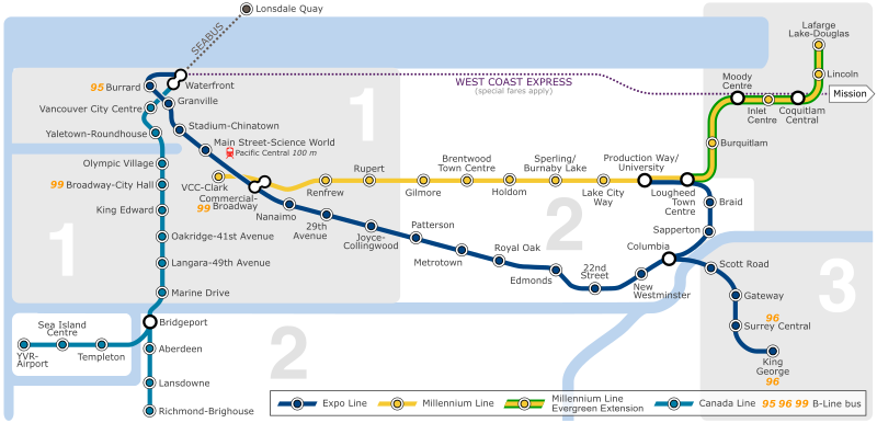
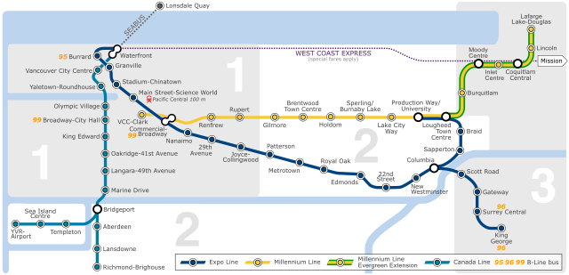
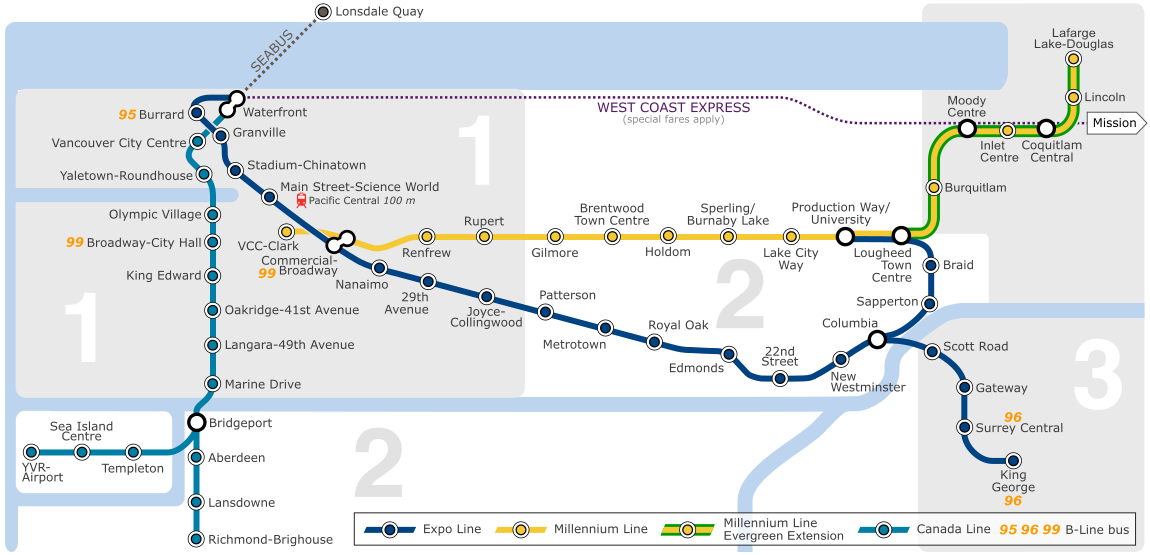
English: A map of the Vancouver SkyTrain.
Français : Un plan de Vancouver SkyTrain.
Deutsch: Eine Karte des Vancouver SkyTrain. |
| Source | Own work |
| Author | Sweetnhappy |
| Other versions | French version / version française |
Licensing
I, the copyright holder of this work, hereby publish it under the following licenses:

|
Permission is granted to copy, distribute and/or modify this document under the terms of the GNU Free Documentation License, Version 1.2 or any later version published by the Free Software Foundation; with no Invariant Sections, no Front-Cover Texts, and no Back-Cover Texts. A copy of the license is included in the section entitled GNU Free Documentation License. |
This file is licensed under the Creative Commons Attribution-Share Alike 3.0 Unported, 2.5 Generic, 2.0 Generic and 1.0 Generic license.
- You are free:
- to share – to copy, distribute and transmit the work
- to remix – to adapt the work
- Under the following conditions:
- attribution – You must give appropriate credit, provide a link to the license, and indicate if changes were made. You may do so in any reasonable manner, but not in any way that suggests the licensor endorses you or your use.
- share alike – If you remix, transform, or build upon the material, you must distribute your contributions under the same or compatible license as the original.
You may select the license of your choice.
File history
Click on a date/time to view the file as it appeared at that time.
| Date/Time | Thumbnail | Dimensions | User | Comment | |
|---|---|---|---|---|---|
| current | 07:28, 17 December 2016 | | 1,150 × 555 (495 KB) | The Big H 2014 | Made WCE dashed line (since it might be confused as being a SkyTrain line otherwise - coming from a reversion from a Wiki user on [https://en.wikipedia.org/wiki/SkyTrain_(Vancouver) SkyTrain (Vancouver)]) |
| 07:43, 14 December 2016 |  | 1,150 × 555 (494 KB) | The Big H 2014 | Removed future extensions (UBC and Langley) | |
| 07:33, 14 December 2016 |  | 1,150 × 555 (502 KB) | The Big H 2014 | Added Evergreen Extension; Added Missing B-Lines; Removed 97 B-Line | |
| 21:33, 29 August 2009 |  | 1,150 × 555 (926 KB) | DavidArthur | Commercial-Broadway renaming as of 7 September; improvements to city-centre precision | |
| 19:44, 10 August 2009 |  | 1,150 × 555 (928 KB) | DavidArthur | Display fixes for MediaWiki compatibility | |
| 19:42, 10 August 2009 |  | 1,150 × 555 (904 KB) | DavidArthur | Revisions for the opening of the Canada Line | |
| 05:58, 31 July 2009 |  | 1,120 × 625 (535 KB) | Emarsee | Update colours per Translink | |
| 03:21, 30 June 2009 |  | 1,120 × 625 (536 KB) | Emarsee | fixed text for the 99 | |
| 17:47, 27 June 2009 |  | 1,120 × 625 (533 KB) | Emarsee | Fixed colour switched from 0008ff to 0080ff | |
| 17:35, 27 June 2009 |  | 1,120 × 625 (522 KB) | Emarsee | The colour of the Canada Line has changed to sky blue per http://forum.skyscraperpage.com/showthread.php?t=138204&page=202 |
File usage
The following page uses this file:
Global file usage
The following other wikis use this file:
- Usage on be-tarask.wikipedia.org
- Usage on ca.wikipedia.org
- Usage on de.wikipedia.org
- Usage on en.wikipedia.org
- Usage on es.wikipedia.org
- Usage on fr.wikipedia.org
- Usage on ja.wikipedia.org
- Usage on ka.wikipedia.org
- Usage on ko.wikipedia.org
- Usage on ku.wikipedia.org
- Usage on nl.wikipedia.org
- Usage on no.wikipedia.org
- Usage on pl.wikipedia.org
- Usage on pt.wikipedia.org
- Usage on ru.wikipedia.org
- Usage on sr.wikipedia.org
- Usage on sv.wikipedia.org
- Usage on th.wikipedia.org
- Usage on tr.wikipedia.org
- Usage on uz.wikipedia.org