File:Spanish Empire Anachronous en.svg
Jump to navigation
Jump to search

Size of this PNG preview of this SVG file: 800 × 407 pixels. Other resolutions: 320 × 163 pixels | 640 × 325 pixels | 1,024 × 520 pixels | 1,280 × 650 pixels | 2,560 × 1,301 pixels | 2,753 × 1,399 pixels.
Original file (SVG file, nominally 2,753 × 1,399 pixels, file size: 1.12 MB)
|
|
This is a file from the Wikimedia Commons |
Summary
| Description |
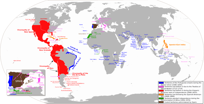
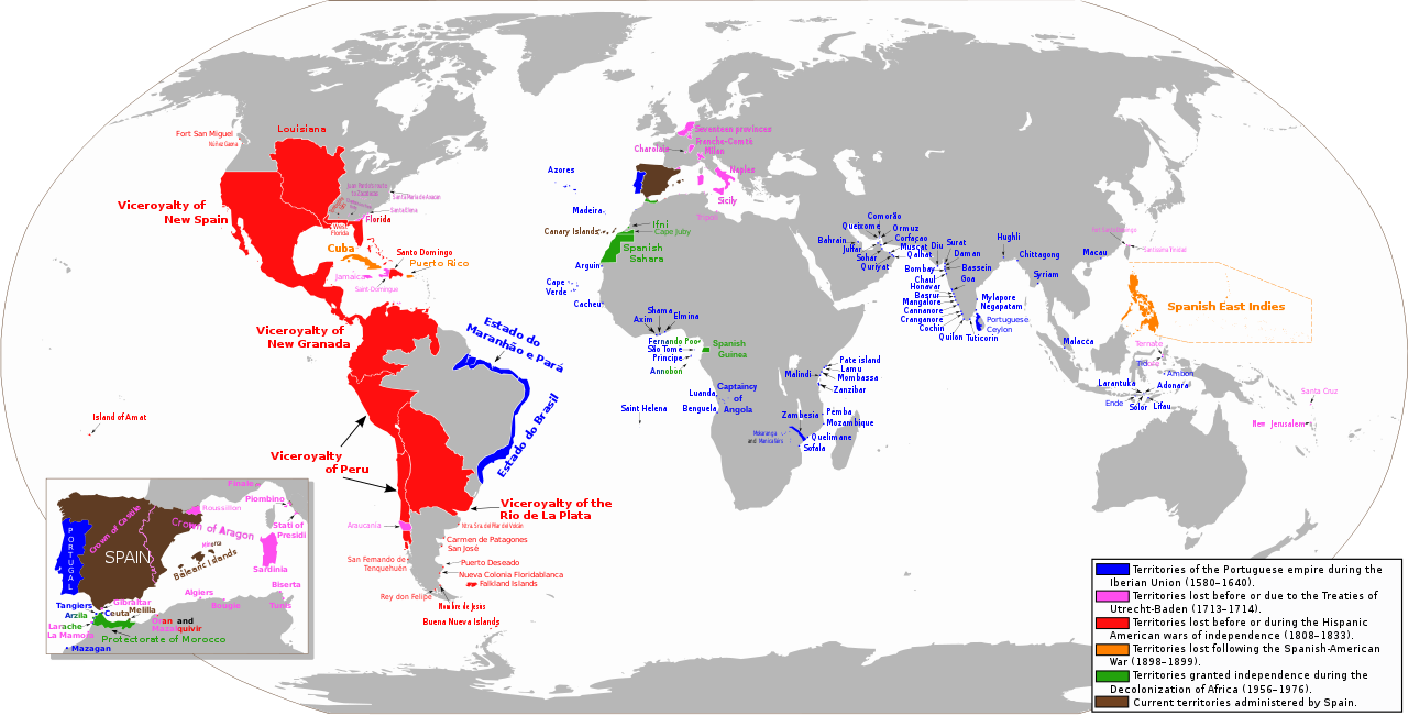
Español: Mapa diacrónico de los territorios del Imperio Español
Territorios del imperio portugués durante la Unión Ibérica (1580-1640)
Territorios hasta los Tratados de Utrecht-Baden (1713–1714)
Territorios hasta las Guerras de independencia hispanoamericana (1808–1833)
Territorios hasta la Guerra Hispano-Estadounidense (1898-1899)
Territorios hasta la Descolonización de África (1956-1976)
Territorios actualmente administrados por España English: Anachronous map of the Spanish Empire
Territories of the Portuguese empire during the Iberian Union (1580-1640)
Territories until the Treaties of Utrecht-Baden (1713–1714)
Territories until the Spanish American wars of independence (1808–1833)
Territories until the Spanish-American War (1898-1899)
Territories granted independence during the Decolonization of Africa (1956-1976)
Current territories administered by Spain |
| Date | |
| Source | Own work. View sources in talk page |
| Author | Trasamundo |
| Permission (Reusing this file) |
trabajo propio (own work) |
| Other versions |
 |
Licensing
I, the copyright holder of this work, hereby publish it under the following licenses:

|
Permission is granted to copy, distribute and/or modify this document under the terms of the GNU Free Documentation License, Version 1.2 or any later version published by the Free Software Foundation; with no Invariant Sections, no Front-Cover Texts, and no Back-Cover Texts. A copy of the license is included in the section entitled GNU Free Documentation License. |
This file is licensed under the Creative Commons Attribution-Share Alike 3.0 Unported, 2.5 Generic, 2.0 Generic and 1.0 Generic license.
- You are free:
- to share – to copy, distribute and transmit the work
- to remix – to adapt the work
- Under the following conditions:
- attribution – You must give appropriate credit, provide a link to the license, and indicate if changes were made. You may do so in any reasonable manner, but not in any way that suggests the licensor endorses you or your use.
- share alike – If you remix, transform, or build upon the material, you must distribute your contributions under the same or compatible license as the original.
You may select the license of your choice.
File history
Click on a date/time to view the file as it appeared at that time.
| Date/Time | Thumbnail | Dimensions | User | Comment | |
|---|---|---|---|---|---|
| current | 02:15, 1 May 2023 | | 2,753 × 1,399 (1.12 MB) | Janitoalevic | Fixed borders and added Araucanía |
| 08:57, 24 April 2023 |  | 2,753 × 1,399 (1.01 MB) | Durero | Araucanía lost after mapuche rebelions. Restored previous version beacuse of borders | |
| 16:05, 13 February 2023 |  | 2,753 × 1,399 (1.12 MB) | Janitoalevic | Added border between Chile and Perú, full Esequibo territory, Buena Nueva Islands and San Fernando de Tenquehuén. | |
| 19:25, 27 November 2019 |  | 2,753 × 1,399 (1.01 MB) | FDRMRZUSA | Corrected error (Siena) for "great" map too. In previous update the correction was restricted to the "little" map (box) on the lower left. No other changes. | |
| 19:00, 27 November 2019 |  | 2,753 × 1,399 (1.01 MB) | FDRMRZUSA | Restored version of 9 June 2013 (latest updated version) but with corrected mistake: Siena was part of the Granduchy of Tuscany. No other changes. | |
| 18:31, 15 November 2019 |  | 2,753 × 1,400 (1.37 MB) | Barjimoa | Reverted to version as of 18:53, 29 March 2009 (UTC) Correcting mistake: Siena was part of the Granduchy of Tuscany. | |
| 21:21, 9 June 2013 |  | 2,753 × 1,399 (1.33 MB) | Trasamundo | Oceanía | |
| 19:27, 28 January 2013 |  | 2,753 × 1,400 (1.53 MB) | Trasamundo | dates | |
| 19:51, 6 September 2012 |  | 2,753 × 1,400 (1.49 MB) | Trasamundo | Iberian Peninsula | |
| 21:27, 29 March 2011 |  | 2,753 × 1,400 (1.52 MB) | Trasamundo | North Amarica: fixing the geographical accuracy, missions, forts |
File usage
The following 2 pages use this file:
Global file usage
The following other wikis use this file:
- Usage on azb.wikipedia.org
- Usage on be.wikipedia.org
- Usage on da.wikipedia.org
- Usage on de.wikipedia.org
- Usage on en.wikipedia.org
- Usage on es.wikipedia.org
- Usage on et.wikipedia.org
- Usage on fr.wikipedia.org
- Usage on gl.wikipedia.org
- Usage on gn.wikipedia.org
- Usage on he.wikipedia.org
- Usage on hy.wikipedia.org
- Usage on id.wikipedia.org
- Usage on ko.wikipedia.org
- Usage on lt.wikipedia.org
- Naujoji Ispanija
- Peru vicekaralystė
- Naujosios Granados vicekaralystė
- Ifnis
- Milano hercogystė
- Sicilijos karalystė
- Ispanijos Rytų Indijos
- Aragono karalystė
- Ispanijos Gvinėja
- Kastilijos karalystė
- Ispanijos Nyderlandai
- Ispanijos imperija
- Ispanijos Marokas
- Ispanijos Formoza
- Barselonos grafystė
- Neapolio karalystė
- Šablonas:Ispanijos imperijos teritorijos
View more global usage of this file.