File:Mount St. Helens, one day before the devastating eruption.jpg
Jump to navigation
Jump to search

Size of this preview: 800 × 541 pixels. Other resolutions: 320 × 216 pixels | 640 × 433 pixels | 1,024 × 692 pixels | 1,280 × 865 pixels | 2,912 × 1,968 pixels.
Original file (2,912 × 1,968 pixels, file size: 3.74 MB, MIME type: image/jpeg)
|
|
This is a file from the Wikimedia Commons |
Summary
| Description |
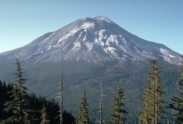
English: This slide shows Mount St. Helens, one day before the devastating eruption. The view is from Johnston Ridge, six miles (10 kilometers) northwest of the volcano.
Bahasa Indonesia: Gambar ini menunjukkan Gunung St. Helens, satu hari sebelum letusan dahsyat. Pemandangannya dari Punggung Bukit Johnston, enam mil (10 kilometer) barat laut gunung berapi.
Italiano: Monte Sant'Elena il giorno prima dell'eruzione del 1980
Slovenčina: Sopka St. Helens pre erupciou v roku 1980.
Español: Esta foto muestra el Monte St. Helens un dia antes de su devastante erupción de 1980, visto desde David A. Johnston. Ridge, seis millas (diez kilómetros) al noroeste del volcán. |
| Date | |
| Source | USGS photo of Mt. Saint Helens |
| Author | Harry Glicken, USGS/CVO |
| Other versions | Derivative works of this file: Sthelens1-animation.gif |
Licensing
This image is in the public domain in the United States because it only contains materials that originally came from the United States Geological Survey, an agency of the United States Department of the Interior. For more information, see the official USGS copyright policy.
|
File history
Click on a date/time to view the file as it appeared at that time.
| Date/Time | Thumbnail | Dimensions | User | Comment | |
|---|---|---|---|---|---|
| current | 05:26, 24 June 2017 | | 2,912 × 1,968 (3.74 MB) | DrNegative | Reverted to version as of 18:40, 5 February 2007 (UTC) Color correction lost 50% of original resolution |
| 08:53, 18 June 2017 |  | 1,280 × 865 (699 KB) | Dpalma01 | Color corrected file. | |
| 18:40, 5 February 2007 |  | 2,912 × 1,968 (3.74 MB) | Siebrand | High res (lossless crop) from http://vulcan.wr.usgs.gov/Imgs/Jpg/MSH/Images/MSH80_st_helens_from_johnston_ridge_05-17-80.jpg | |
| 20:22, 14 March 2006 |  | 540 × 360 (39 KB) | Reelax | ==Description== USGS photo of Mt. Saint Helens. '''Caption''': This slide shows Mount St. Helens on May 17, 1980, one day before the devastating eruption. The view is from Johnston Ridge, six miles (10 kilometers) northwest o |
File usage
The following page uses this file:
Global file usage
The following other wikis use this file:
- Usage on af.wikipedia.org
- Usage on ar.wikipedia.org
- Usage on ast.wikipedia.org
- Usage on bn.wikipedia.org
- Usage on ca.wikipedia.org
- Usage on cs.wikipedia.org
- Usage on de.wikipedia.org
- Usage on el.wikipedia.org
- Usage on en.wikipedia.org
- Usage on en.wikiquote.org
- Usage on en.wikiversity.org
- Usage on es.wikipedia.org
- Usage on fa.wikipedia.org
- Usage on fi.wikipedia.org
- Usage on fr.wikipedia.org
- Usage on hi.wikipedia.org
- Usage on hr.wikipedia.org
- Usage on hu.wikipedia.org
- Usage on id.wikipedia.org
- Usage on is.wikipedia.org
- Usage on it.wikipedia.org
- Usage on it.wikibooks.org
- Usage on it.wikiversity.org
- Usage on ja.wikipedia.org
- Usage on ko.wikipedia.org
- Usage on ms.wikipedia.org
- Usage on nl.wikipedia.org
View more global usage of this file.