File:Missions in Somaliland.png
Jump to navigation
Jump to search

Size of this preview: 800 × 370 pixels. Other resolutions: 320 × 148 pixels | 640 × 296 pixels | 1,357 × 628 pixels.
Original file (1,357 × 628 pixels, file size: 19 KB, MIME type: image/png)
|
|
This is a file from the Wikimedia Commons |

|
File:Diplomatic missions in Somaliland.svg is a vector version of this file. It should be used in place of this PNG file when not inferior.
File:Missions in Somaliland.png → File:Diplomatic missions in Somaliland.svg
For more information, see Help:SVG. |
 |
Summary
| Description |
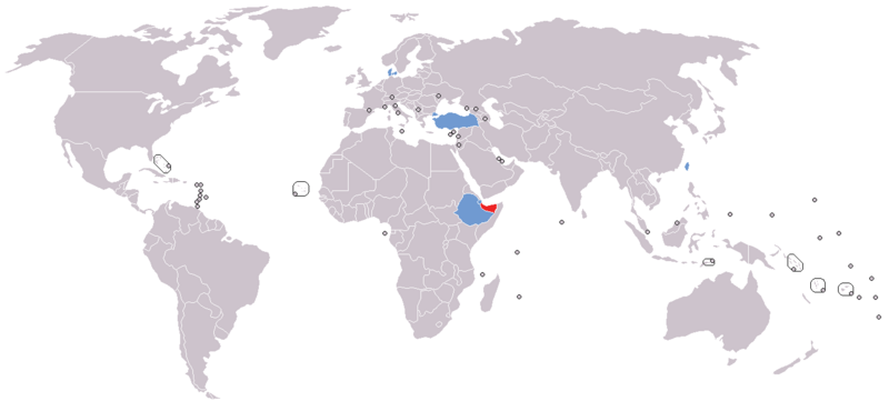
English: Map of diplomatic missions in Somaliland
Somaliland
States with embassy in Somaliland (none)
States with representative office or consulate in Somaliland
States with non-resident embassy in Somaliland (none)
Disputed region |
| Date | |
| Source |
Own work This file was derived from: World map model.png |
| Author | Jan CZ |
Licensing
I, the copyright holder of this work, hereby publish it under the following license:
| This file is made available under the Creative Commons CC0 1.0 Universal Public Domain Dedication. | |
| The person who associated a work with this deed has dedicated the work to the public domain by waiving all of their rights to the work worldwide under copyright law, including all related and neighboring rights, to the extent allowed by law. You can copy, modify, distribute and perform the work, even for commercial purposes, all without asking permission.
|
File history
Click on a date/time to view the file as it appeared at that time.
| Date/Time | Thumbnail | Dimensions | User | Comment | |
|---|---|---|---|---|---|
| current | 10:05, 4 November 2023 | | 1,357 × 628 (19 KB) | Siirski | Reverted to version as of 15:07, 22 August 2020 (UTC) |
| 18:50, 1 October 2023 |  | 1,357 × 628 (37 KB) | Caawiyahaderon | https://www.thehindu.com/news/international/pro-somalia-militia-takes-key-army-base-in-breakaway-region/article67238670.ece | |
| 15:07, 22 August 2020 |  | 1,357 × 628 (19 KB) | Tom282f3 | Added Taiwan in the map. Representative offices established in both countries' capital. | |
| 17:52, 20 June 2020 |  | 1,357 × 628 (26 KB) | Kzl55 | Reverted to version as of 12:11, 19 June 2020 (UTC) Irrelevant, reverted to stable version | |
| 15:07, 20 June 2020 |  | 1,357 × 628 (37 KB) | Meelpringthusss | If Sool, Sanaag and Cayn residents believe Somaliland doesn't represent them, then the map shouldn't mislead people into thinking they do. Clarified at File_talk:Somalia_map_states_regions_districts.png#There_is_nuance_with_regards_to_control | |
| 12:11, 19 June 2020 |  | 1,357 × 628 (26 KB) | Chipmunkdavis | Reverted to version as of 21:24, 14 April 2016 (UTC) Irrelevant to the image, adds no clarity. | |
| 11:22, 17 June 2020 |  | 1,357 × 628 (37 KB) | Meelpringthusss | added disputed region | |
| 21:24, 14 April 2016 |  | 1,357 × 628 (26 KB) | Jan CZ | User created page with UploadWizard |
File usage
The following page uses this file:
Global file usage
The following other wikis use this file:
- Usage on so.wikipedia.org
- Usage on zh.wikipedia.org