File:Location greek ancient.svg
Jump to navigation
Jump to search

Size of this PNG preview of this SVG file: 302 × 176 pixels. Other resolutions: 320 × 186 pixels | 640 × 373 pixels | 1,024 × 597 pixels | 1,280 × 746 pixels | 2,560 × 1,492 pixels.
Original file (SVG file, nominally 302 × 176 pixels, file size: 257 KB)
|
|
This is a file from the Wikimedia Commons |
Summary
| Description |
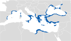
English: Location of Greek ancient. |
||
| Date | |||
| Source | |||
| Author |
|
||
| Permission (Reusing this file) |
|

Licensing
I, the copyright holder of this work, hereby publish it under the following license:
This file is licensed under the Creative Commons Attribution-Share Alike 3.0 Unported license.
- You are free:
- to share – to copy, distribute and transmit the work
- to remix – to adapt the work
- Under the following conditions:
- attribution – You must give appropriate credit, provide a link to the license, and indicate if changes were made. You may do so in any reasonable manner, but not in any way that suggests the licensor endorses you or your use.
- share alike – If you remix, transform, or build upon the material, you must distribute your contributions under the same or compatible license as the original.
File history
Click on a date/time to view the file as it appeared at that time.
| Date/Time | Thumbnail | Dimensions | User | Comment | |
|---|---|---|---|---|---|
| current | 13:32, 15 December 2016 | | 302 × 176 (257 KB) | SilentResident | Fixed map inaccuracies about the Greek kingdoms of Macedonia and Epirus, which were part of the Greek world. Not including them, has caused inaccuracies and inconsistencies on the map, especially in the part where the map displays the Epirote colonies... |
| 10:04, 8 August 2012 |  | 302 × 176 (185 KB) | The Emirr | Color change. | |
| 14:56, 7 August 2012 |  | 302 × 176 (184 KB) | The Emirr | {{Information |Description ={{en|1=Location of Greek ancient.}} |Source =*[http://www.wwnorton.com/nrl/english/nawol/maps/MAP7GRCO.JPG www.wwnorton.com] |Author ={{click|image=Maplab-logo.svg|link=User:The Emirr/MapLab|width=60px|hei... |
File usage
The following 3 pages use this file:
Global file usage
The following other wikis use this file:
- Usage on af.wikipedia.org
- Usage on als.wikipedia.org
- Usage on an.wikipedia.org
- Usage on ar.wikipedia.org
- Usage on ast.wikipedia.org
- Usage on azb.wikipedia.org
- Usage on az.wikipedia.org
- Usage on ba.wikipedia.org
- Usage on be.wikipedia.org
- Usage on bg.wikipedia.org
- Usage on br.wikipedia.org
- Usage on ca.wikipedia.org
- Usage on ckb.wikipedia.org
- Usage on cs.wikipedia.org
- Usage on cy.wikipedia.org
- Usage on da.wikipedia.org
- Usage on de.wikipedia.org
- Usage on diq.wikipedia.org
- Usage on el.wikipedia.org
- Usage on en.wikipedia.org
- Usage on eo.wikipedia.org
- Usage on es.wikipedia.org
- Usage on eu.wikipedia.org
- Usage on fa.wikipedia.org
- Usage on fo.wikipedia.org
- Usage on fr.wikipedia.org
View more global usage of this file.