File:Ince Castle - geograph.org.uk - 344828 cropped.jpg
Jump to navigation
Jump to search
No higher resolution available.
Ince_Castle_-_geograph.org.uk_-_344828_cropped.jpg (244 × 148 pixels, file size: 17 KB, MIME type: image/jpeg)
|
|
This is a file from the Wikimedia Commons |
Summary
| Description |
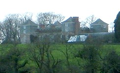
English: Ince Castle, 3 miles (5 km) from Saltash, Cornwall, England. It was built in 1642 at the start of the Civil War and was captured in 1646. It consists of 4 three storey towers with walls 4 foot thick. By the 1850s it was used as a farm and was allowed to decay but it was restored in the early 20th century. It burnt down in 1986 (apparently by grandmother being a bit irresponsible with a candle) – but it has now been rebuilt. In 1649, John Killigrew inherited Ince Castle from an uncle. He married four wives and installed them separately into each of the four towers giving them a story that the fields were plagued with mice – which kept them inside. For some time, each of the four ladies lived happily in ignorance of the other three, until a thicko servant delivered a letter to the wrong wife, and all was revealed! John Killigrew was sentenced to sixteen years, four years for each count of bigamy. John pointed out to the judge that, as his first marriage was not bigamous, he should serve only twelve years! Good lad. It is now the home of Lord and Lady Boyd who probably wouldn't like to see me making footprints in their ever so posh mud. |
| Date | |
| Source |
This file was derived from: Ince Castle - geograph.org.uk - 344828.jpg |
| Author | Bill Booth |
| Other versions |

| Camera location | | View this and other nearby images on: OpenStreetMap |
|---|
_region:GB-GBN_heading:225.00&language=en)
| Object location | | View this and other nearby images on: OpenStreetMap |
|---|
_region:GB-GBN_heading:225.00&language=en)
This file is licensed under the Creative Commons Attribution-Share Alike 2.0 Generic license.
Attribution: Bill Booth
- You are free:
- to share – to copy, distribute and transmit the work
- to remix – to adapt the work
- Under the following conditions:
- attribution – You must give appropriate credit, provide a link to the license, and indicate if changes were made. You may do so in any reasonable manner, but not in any way that suggests the licensor endorses you or your use.
- share alike – If you remix, transform, or build upon the material, you must distribute your contributions under the same or compatible license as the original.
Original upload log
This image is a derivative work of the following images:
- File:Ince Castle - geograph.org.uk - 344828.jpg licensed with Cc-by-sa-2.0, Geograph
- 2011-01-02T17:18:58Z GeographBot 640x435 (64700 Bytes) == {{int:filedesc}} == {{Information |description={{en|1=Ince Castle This is Ince Castle which was built in 1642 at the start of the Civil War and was captured in 1646. It consists of 4 three storey towers with walls 4 foot t
Uploaded with derivativeFX
File history
Click on a date/time to view the file as it appeared at that time.
| Date/Time | Thumbnail | Dimensions | User | Comment | |
|---|---|---|---|---|---|
| current | 17:15, 12 May 2011 | | 244 × 148 (17 KB) | Paravane | {{Information |Description={{en|1=Ince Castle This is Ince Castle which was built in 1642 at the start of the Civil War and was captured in 1646. It consists of 4 three storey towers with walls 4 foot thick. By the 1850s it was used as a farm and was allo |
File usage
The following 2 pages use this file:
Global file usage
The following other wikis use this file:
- Usage on da.wikipedia.org
- Usage on de.wikipedia.org
- Usage on en.wikipedia.org
- Usage on pt.wikipedia.org
- Usage on ru.wikipedia.org