File:Illyrians.jpg
Jump to navigation
Jump to search

Size of this preview: 800 × 542 pixels. Other resolutions: 320 × 217 pixels | 640 × 434 pixels | 1,054 × 714 pixels.
Original file (1,054 × 714 pixels, file size: 1.27 MB, MIME type: image/jpeg)
|
|
This is a file from the Wikimedia Commons |
Summary
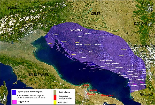
| Description | Map of the Illyrian tribes | ||||||||||||
| Date | |||||||||||||
| Source |
Own work data from
|
||||||||||||
| Author | User:Megistias | ||||||||||||
| Permission (Reusing this file) |
I, the copyright holder of this work, hereby publish it under the following licenses:
This file is licensed under the Creative Commons Attribution-Share Alike 2.5 Generic license.
You may select the license of your choice. |
||||||||||||
| Other versions |
|


.png)

.svg)
.svg)
.svg)
Licensing
I, the copyright holder of this work, hereby publish it under the following licenses:

|
Permission is granted to copy, distribute and/or modify this document under the terms of the GNU Free Documentation License, Version 1.2 or any later version published by the Free Software Foundation; with no Invariant Sections, no Front-Cover Texts, and no Back-Cover Texts. A copy of the license is included in the section entitled GNU Free Documentation License. |
| This file is licensed under the Creative Commons Attribution-Share Alike 3.0 Unported license. | ||
| ||
| This licensing tag was added to this file as part of the GFDL licensing update. |
You may select the license of your choice.
File history
Click on a date/time to view the file as it appeared at that time.
| Date/Time | Thumbnail | Dimensions | User | Comment | |
|---|---|---|---|---|---|
| current | 18:06, 19 July 2016 | | 1,054 × 714 (1.27 MB) | MaryroseB54 | The Illyrian Atintani, the Epirotic Atintanes and the Roman Protectorate N. G. L. Hammond, The Journal of Roman Studies Vol. 79 (1989), pp. 11-25 "There were Illyrian Amantini in Pannonia and Greek Amantes in North Epirus" |
| 18:04, 14 August 2011 |  | 1,054 × 714 (1.27 MB) | Martin H. | Reverted to version as of 13:39, 11 February 2010. Bad overwriting | |
| 17:41, 14 August 2011 | No thumbnail | 640 × 586 (101 KB) | AceDouble | original map. | |
| 13:39, 11 February 2010 |  | 1,054 × 714 (1.27 MB) | Megistias | lopsi | |
| 13:38, 11 February 2010 |  | 1,054 × 714 (1.27 MB) | Megistias | lopsi | |
| 21:45, 22 January 2010 |  | 1,054 × 714 (1.27 MB) | Megistias | tweaks | |
| 10:21, 30 September 2009 |  | 1,054 × 714 (1.27 MB) | Megistias | correction | |
| 09:59, 30 September 2009 |  | 1,054 × 714 (1.27 MB) | Megistias | Update | |
| 21:52, 29 September 2009 |  | 1,054 × 714 (1.28 MB) | Megistias | Update | |
| 11:36, 22 September 2009 |  | 1,054 × 714 (1.23 MB) | Megistias | update |
File usage
There are no pages that use this file.
Global file usage
The following other wikis use this file:
- Usage on bs.wikipedia.org
- Usage on de.wikipedia.org
- Usage on en.wikipedia.org
- Usage on fr.wikipedia.org
- Usage on hr.wikipedia.org
- Usage on pl.wikipedia.org
- Usage on sh.wikipedia.org
- Usage on sl.wikipedia.org
- Usage on sq.wikipedia.org
- Usage on sr.wikipedia.org
- Usage on tr.wikipedia.org
- Usage on www.wikidata.org