File:Earth's water distribution.svg

Original file (SVG file, nominally 430 × 350 pixels, file size: 31 KB)
|
|
This is a file from the Wikimedia Commons |
Summary
This file is translated using SVG <switch> elements. All translations are stored in the same file! Learn more.
For most Wikipedia projects, you can embed the file normally (without a To translate the text into your language, you can use the SVG Translate tool. Alternatively, you can download the file to your computer, add your translations using whatever software you're familiar with, and re-upload it with the same name. You will find help in Graphics Lab if you're not sure how to do this. |
| Description |
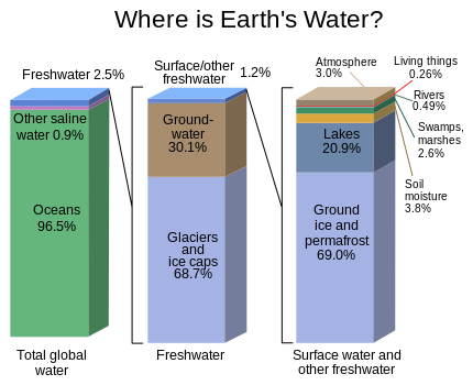
English: Graph of the locations of water on Earth |
| Source | https://water.usgs.gov/edu/gallery/watercyclekids/earth-water-distribution.html - traced and redrawn from File:Earth's water distribution.gif |
| Author | USGS |
| Other versions | Earth's water distribution-gl.svg |
| SVG development | This vector image was created with Inkscape. |
Licensing
This image is in the public domain in the United States because it only contains materials that originally came from the United States Geological Survey, an agency of the United States Department of the Interior. For more information, see the official USGS copyright policy.
|
File history
Click on a date/time to view the file as it appeared at that time.
| Date/Time | Thumbnail | Dimensions | User | Comment | |
|---|---|---|---|---|---|
| current | 22:28, 31 January 2024 | | 430 × 350 (31 KB) | Asierog | spanish and french translations added |
| 12:32, 22 November 2016 |  | 430 × 350 (25 KB) | MaxxL | updated | |
| 14:00, 22 May 2010 |  | 530 × 368 (202 KB) | Begoon | {{Information |Description={{en|1=Graph of the locations of water on Earth}} |Source=http://ga.water.usgs.gov/edu/waterdistribution.html |Author=USGS |Date= |Permission= |other_versions= }} |
File usage
The following page uses this file:
Global file usage
The following other wikis use this file:
- Usage on el.wikipedia.org
- Usage on en.wikipedia.org
- Usage on en.wikiversity.org
- Usage on es.wikipedia.org
- Usage on et.wikipedia.org
- Usage on eu.wikipedia.org
- Usage on fr.wikipedia.org
- Usage on gu.wikipedia.org
- Usage on hi.wikipedia.org
- Usage on hy.wikipedia.org
- Usage on ka.wikipedia.org
- Usage on ms.wikipedia.org
- Usage on si.wikipedia.org
- Usage on te.wikipedia.org
- Usage on tr.wikipedia.org
- Usage on vi.wikipedia.org
- Usage on zh.wikipedia.org