This is a file from the Wikimedia Commons

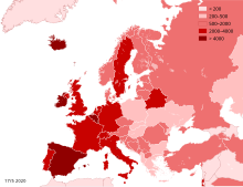
File:Coronavirus infected persons per capita in Europe.svg

From Wikibooks, open books for an open world
Jump to navigation Jump to search

Original file(SVG file, nominally 680 × 520 pixels, file size: 749 KB)

Summary

Description
English: Coronavirus infected persons per population of the countries in Europe. Date: see lower left corner of the map. Legend shows number of persons infected per million people.
Date
Source
Author Pechristener
Other versions File:Red COVID-19 Outbreak Cases per capita in Europe.svg
SVG development
InfoField
 
The SVG code is valid.
 
This map was created with Inkscape…important.


This file may be updated to reflect new information.
If you wish to use a specific version of the file without new updates being mirrored, please upload the required version as a separate file.
Peter Christener, the copyright holder of this work, hereby publishes it under the following license:
w:en:Creative Commons
attribution share alike
This file is licensed under the Creative Commons Attribution-Share Alike 4.0 International license.
Attribution: Peter Christener
You are free:
  • to share – to copy, distribute and transmit the work
  • to remix – to adapt the work
Under the following conditions:
  • attribution – You must give appropriate credit, provide a link to the license, and indicate if changes were made. You may do so in any reasonable manner, but not in any way that suggests the licensor endorses you or your use.
  • share alike – If you remix, transform, or build upon the material, you must distribute your contributions under the same or compatible license as the original.

Captions

Add a one-line explanation of what this file represents

Items portrayed in this file

depicts

17 May 2020

image/svg+xml

4c843ca083cce87c6553002d2ef1616b6d5f5e0c

767,360 byte

520 pixel

680 pixel

File history

Click on a date/time to view the file as it appeared at that time.

(newest | oldest) View (newer 10 | ) (10 | 20 | 50 | 100 | 250 | 500)
Date/TimeThumbnailDimensionsUserComment
current03:33, 17 May 2020Thumbnail for version as of 03:33, 17 May 2020680 × 520 (749 KB)Pechristenerupdate May 17
14:41, 3 May 2020Thumbnail for version as of 14:41, 3 May 2020680 × 520 (749 KB)PechristenerMap update May 3
16:35, 25 April 2020Thumbnail for version as of 16:35, 25 April 2020680 × 520 (750 KB)PechristenerMap update April 25
19:57, 22 April 2020Thumbnail for version as of 19:57, 22 April 2020680 × 520 (750 KB)PechristenerMap updated April 22
12:07, 19 April 2020Thumbnail for version as of 12:07, 19 April 2020680 × 520 (749 KB)PechristenerMap update April 19
13:32, 15 April 2020Thumbnail for version as of 13:32, 15 April 2020680 × 520 (749 KB)PechristenerMap update April 15
15:49, 11 April 2020Thumbnail for version as of 15:49, 11 April 2020680 × 520 (749 KB)Pechristenermap update April 11
04:02, 9 April 2020Thumbnail for version as of 04:02, 9 April 2020680 × 520 (749 KB)PechristenerMap update April 9
00:09, 6 April 2020Thumbnail for version as of 00:09, 6 April 2020680 × 520 (749 KB)Pechristenermap update April 6
21:42, 3 April 2020Thumbnail for version as of 21:42, 3 April 2020680 × 520 (749 KB)Pechristenermap update April 3, scale adapted
(newest | oldest) View (newer 10 | ) (10 | 20 | 50 | 100 | 250 | 500)

The following page uses this file:

Global file usage

The following other wikis use this file:

Metadata