File:Ocean currents 1943 for colorblind users.png
Jump to navigation
Jump to search

Size of this preview: 800 × 405 pixels. Other resolutions: 320 × 162 pixels | 640 × 324 pixels | 1,024 × 519 pixels | 1,280 × 649 pixels | 2,577 × 1,306 pixels.
Original file (2,577 × 1,306 pixels, file size: 3.15 MB, MIME type: image/png)
|
|
This is a file from the Wikimedia Commons |

|
This map image could be re-created using vector graphics as an SVG file. This has several advantages; see Commons:Media for cleanup for more information. If an SVG form of this image is available, please upload it and afterwards replace this template with
{{vector version available|new image name}}.
It is recommended to name the SVG file “Ocean currents 1943 for colorblind users.svg”—then the template Vector version available (or Vva) does not need the new image name parameter. |
Summary
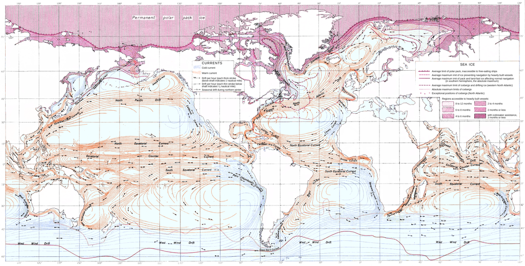
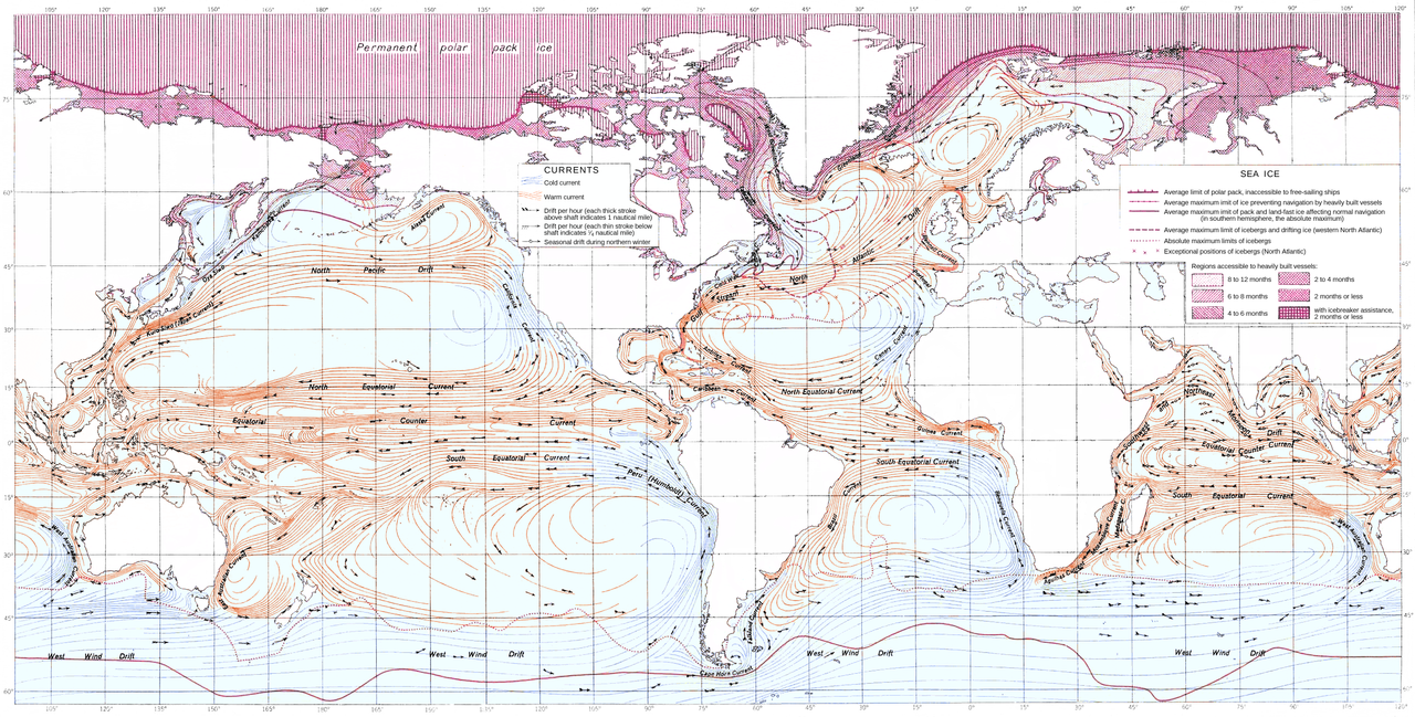
| Description | Re-colored (for readability by color blind persons) version of Ocean Currents and Sea Ice from Atlas of World Maps, United States Army Service Forces, Army Specialized Training Division. Army Service Forces Manual M-101 (1943). |
| Date | (UTC) |
| Source | |
| Author |
|
| Other versions | Derivative works of this file: Ocean currents 1943 for colorblind Pacific.png |
.png)
| This is a retouched picture, which means that it has been digitally altered from its original version. Modifications: Readability by color blind vieweres. The original can be viewed here: Ocean currents 1943 (borderless).png:
|
Licensing
This file is a work of a U.S. Army soldier or employee, taken or made as part of that person's official duties. As a work of the U.S. federal government, it is in the public domain in the United States.
|
 |
Original upload log
This image is a derivative work of the following images:
- File:Ocean_currents_1943_(borderless).png licensed with PD-USGov-Military-Army
- 2008-04-07T18:27:01Z Jrockley 2577x1306 (2882526 Bytes) fix finland
- 2008-04-06T01:40:57Z Jrockley 2579x1307 (2906634 Bytes) remove image border too
- 2008-04-06T01:34:07Z Jrockley 2639x1406 (5173462 Bytes) {{Information |Description=''Ocean Currents and Sea Ice from Atlas of World Maps'', [[United States Army]] Service Forces, Army Specialized Training Division. Army Service Forces Manual M-101 (1943). |Source=http://www.lib.ut
Uploaded with derivativeFX
File history
Click on a date/time to view the file as it appeared at that time.
| Date/Time | Thumbnail | Dimensions | User | Comment | |
|---|---|---|---|---|---|
| current | 18:07, 9 October 2011 | | 2,577 × 1,306 (3.15 MB) | Accountalive | == {{int:filedesc}} == {{Information |Description=Re-colored (for readability by color blind persons) version of ''Ocean Currents and Sea Ice from Atlas of World Maps'', United States Army Service Forces, Army Specialized Training Division. Army Servi |
File usage
The following 3 pages use this file:
Global file usage
The following other wikis use this file:
- Usage on de.wikipedia.org