File:Romia Imperio.png
Jump to navigation
Jump to search
Size of this preview: 800 × 548 pixels. Other resolutions: 320 × 219 pixels | 640 × 438 pixels | 1,024 × 701 pixels | 1,280 × 877 pixels | 1,600 × 1,096 pixels.
Original file (1,600 × 1,096 pixels, file size: 52 KB, MIME type: image/png)
|
|
This is a file from the Wikimedia Commons |
| Description |
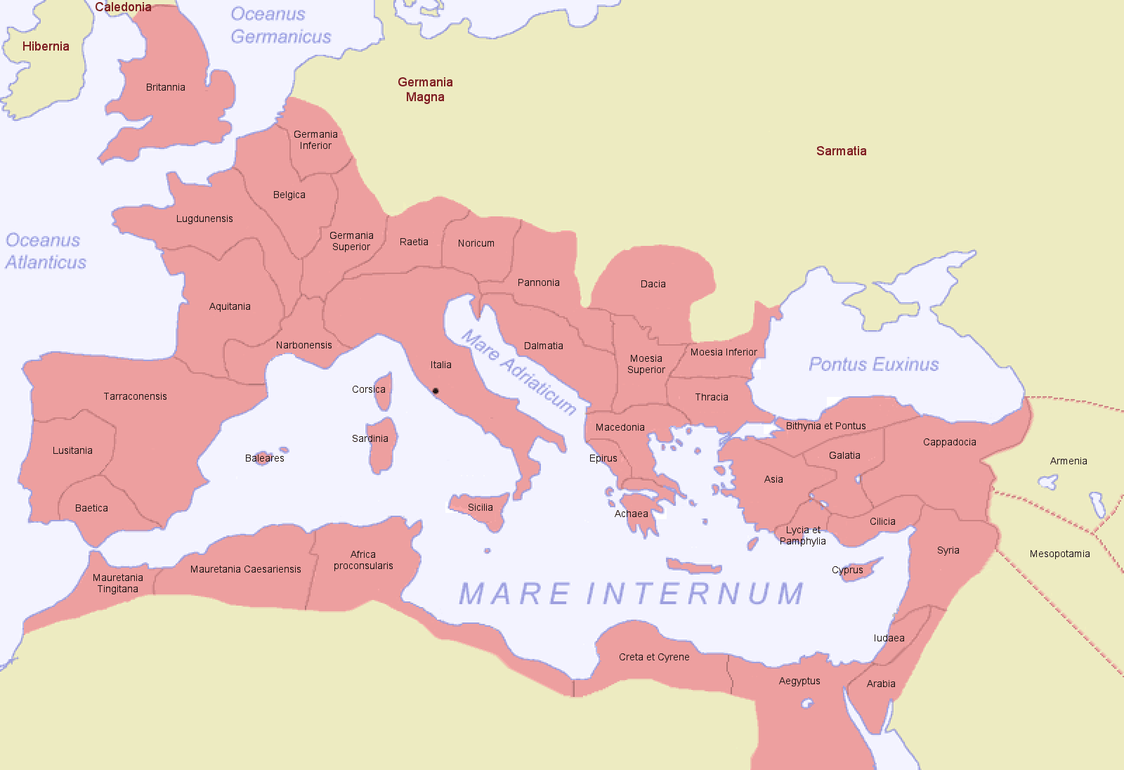
Беларуская (тарашкевіца): Мапа Рымскай імпэрыі на 116 год.
|
| Date | |
| Source |
Own work based on: Roman Empire Map.png by Jniemenmaa
|
| Author | Thomas Pusch at Esperanto Wikipedia |
| Other versions |
|
Summary

|
Permission is granted to copy, distribute and/or modify this document under the terms of the GNU Free Documentation License, Version 1.2 or any later version published by the Free Software Foundation; with no Invariant Sections, no Front-Cover Texts, and no Back-Cover Texts. A copy of the license is included in the section entitled GNU Free Documentation License. |
| This file is licensed under the Creative Commons Attribution-Share Alike 3.0 Unported license. | ||
| ||
| This licensing tag was added to this file as part of the GFDL licensing update. |
File history
Click on a date/time to view the file as it appeared at that time.
| Date/Time | Thumbnail | Dimensions | User | Comment | |
|---|---|---|---|---|---|
| current | 15:33, 16 November 2022 | | 1,600 × 1,096 (52 KB) | Gyalu22 | Reverted to version as of 05:33, 29 June 2007 (UTC) |
| 16:24, 5 April 2020 |  | 1,600 × 1,096 (51 KB) | Julieta39 | Alpes & Taurida | |
| 08:05, 19 June 2019 |  | 1,600 × 1,096 (47 KB) | Yann | Reverted to version as of 14:52, 4 February 2012 (UTC) | |
| 13:42, 17 June 2019 |  | 1,000 × 685 (240 KB) | SuperSucker | fix - date added | |
| 14:52, 4 February 2012 |  | 1,600 × 1,096 (47 KB) | AnonMoos | increase PNG compression | |
| 12:04, 29 December 2009 |  | 1,600 × 1,096 (68 KB) | Olahus | m | |
| 05:33, 29 June 2007 |  | 1,600 × 1,096 (52 KB) | ThomasPusch | Name of "Mauretania Caesariensis'' (one "s" was missing) corrected - nomo de "Mauretania Caesariensis'' korektita | |
| 09:27, 24 June 2007 |  | 1,600 × 1,096 (52 KB) | ThomasPusch | Borders of ''Africa'' and ''Asia'' corrected - Limoj de ''Afriko'' kaj ''Azio'' korektitaj | |
| 05:45, 20 June 2007 |  | 800 × 548 (45 KB) | ThomasPusch | Tarragonensis corrected/berichtigt/korektita | |
| 06:28, 16 June 2007 |  | 800 × 548 (46 KB) | ThomasPusch | == {{int:filedesc}} == {{en:Map of the Roman Empire during 116}} {{de:Karte des Römischen Reichs von 116}} {{eo:Mapo de la Romia Imperio de 116}} '' |
File usage
The following 2 pages use this file:
Global file usage
The following other wikis use this file:
- Usage on ast.wikipedia.org
- Usage on ba.wikipedia.org
- Usage on ca.wikipedia.org
- Usage on ceb.wikipedia.org
- Usage on de.wikipedia.org
- Usage on eo.wikipedia.org
- Anatolio
- Asia (provinco)
- Romio
- Raetia
- Romia Imperio
- Baetica
- Panonio
- Noricum
- Aquitania
- Gaŭlio
- Trakio
- Gallia Belgica
- Germania Superior
- Germania Inferior
- Achaea
- Dalmatia
- Gallia Lugdunensis
- Gallia Narbonensis
- Moesia Superior
- Moesia Inferior
- Moesia
- Luzitanio
- Hispania Tarraconensis
- Cirenaiko
- Aegyptus
- Kilikio
- Africa Proconsularis
- Galatia
- Lycia et Pamphylia
- Arabia Petraea
- Sirio (romia provinco)
- Mauretania Tingitana
- Mauretania Caesariensis
- Corsica et Sardinia
- Bithynia et Pontus
- Cappadocia (Romia Imperio)
- Cyprus
- Epirus
- Sicilia
- Britannia
- Macedonia (Romia Imperio)
View more global usage of this file.