File:Cartesian coordinates 2D.svg
Jump to navigation
Jump to search

Size of this PNG preview of this SVG file: 646 × 599 pixels. Other resolutions: 259 × 240 pixels | 518 × 480 pixels | 828 × 768 pixels | 1,104 × 1,024 pixels | 2,208 × 2,048 pixels.
Original file (SVG file, nominally 800 × 742 pixels, file size: 57 KB)
|
|
This is a file from the Wikimedia Commons |
Summary
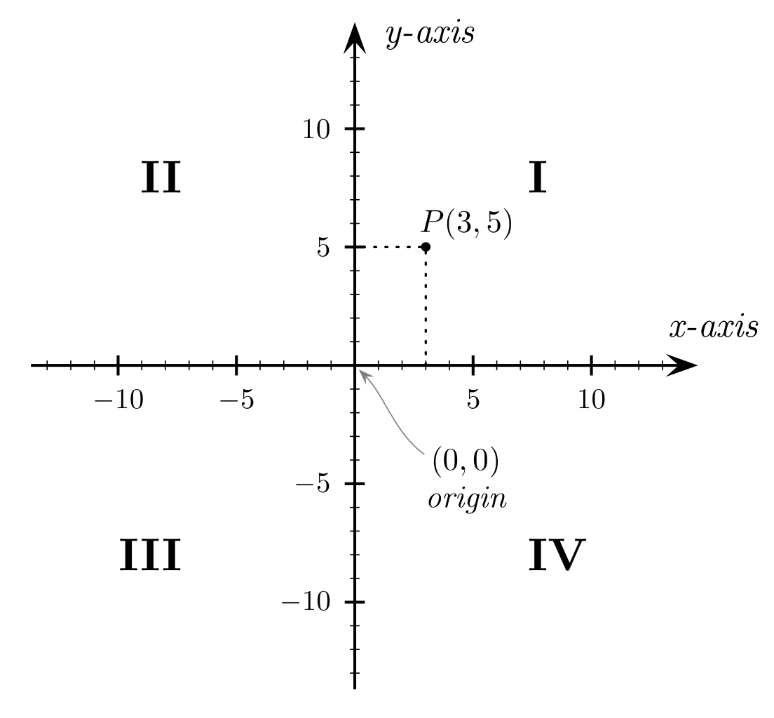
Example for en:Cartesian coordinate system. Created by Gustavb using en:PSTricks.
Licensing
I, the copyright holder of this work, hereby publish it under the following license:

|
Permission is granted to copy, distribute and/or modify this document under the terms of the GNU Free Documentation License, Version 1.2 or any later version published by the Free Software Foundation; with no Invariant Sections, no Front-Cover Texts, and no Back-Cover Texts. A copy of the license is included in the section entitled GNU Free Documentation License. |
| This file is licensed under the Creative Commons Attribution-Share Alike 3.0 Unported license. | ||
| ||
| This licensing tag was added to this file as part of the GFDL licensing update. |
Other versions
-
 македонски

Source
Cartesian_coordinates_2D.tex (PSTricks source)
\input pst-eps\input pst-plot97\input pst-node\TeXtoEPS

\psset{linecolor=black,linewidth=1pt,arrowsize=8pt,unit=0.29cm}
\pspicture*(-15.3,-15.3)(17.4,15.3)

% Axes
\psaxes[Dx=5,Dy=5]{<->}(0,0)(-14.5,-14.5)(14.5,14.5)
\psset{linewidth=.4pt}
\psaxes[Dx=1,Dy=1,labels=none,ticksize=1.5pt](0,0)(-13,-13)(13,13)
\uput{10pt}[0](0,14){\psscalebox{1.25}{\it y-axis}}
\uput{10pt}[70](14,0){\psscalebox{1.25}{\it x-axis}}

% Origin
\pnode(0,0){O}
\uput{35pt}[310](0,0){\rnode{Ot}{\psscalebox{1.1}{
        \vbox{\halign{\hfil#\hfil\cr$(0,0)$\cr\it origin\cr}}}}}
\nccurve[angleA=315,angleB=145,arrowsize=4pt,
        nodesepA=2pt,nodesepB=-3pt,linecolor=gray]{<-}{O}{Ot}

% Point
\psdots[dotstyle=*,dotscale=1.2](3,5)
\psline[linestyle=dotted,linewidth=.8pt](3,0)(3,5)(0,5)
\uput{2.5pt}[53](3,5){\psscalebox{1.1}{$P(3,5)$}}


% Quadrants
\uput{3cm}[45](0,0){\psscalebox{1.6}{\bf I}}
\uput{3cm}[135](0,0){\psscalebox{1.6}{\bf II}}
\uput{3cm}[225](0,0){\psscalebox{1.6}{\bf III}}
\uput{3cm}[315](0,0){\psscalebox{1.6}{\bf IV}}

\endpspicture
\endTeXtoEPS
\nopagenumbers
\end
Instructions
- Create EPS
$ tex Cartesian_coordinates_2D.tex && dvips -E Cartesian_coordinates_2D.dvi
- Outline fonts
$ eps2eps -dNOCACHE Cartesian_coordinates_2D.ps Cartesian_coordinates_2D2.eps
- Fix bounding box
$ ps2epsi Cartesian_coordinates_2D2.eps Cartesian_coordinates_2D.eps
- Convert to Sketch
$ pstoedit -f sk Cartesian_coordinates_2D.eps Cartesian_coordinates_2D.sk
- Convert to SVG
$ skconvert Cartesian_coordinates_2D.sk Cartesian_coordinates_2D.svg
- Fix Cartesian_coordinates_2D.svg with Inkscape
Alternate Instructions
latex Cartesian_coordinates_2D.tex
dvips -E Cartesian_coordinates_2D.dvi
eps2eps -dNOCACHE Cartesian_coordinates_2D.ps Cartesian_coordinates_2D.eps
ps2epsi Cartesian_coordinates_2D.eps Cartesian_coordinates_2D.ps
ps2pdf Cartesian_coordinates_2D.ps
pdf2svg Cartesian_coordinates_2D.pdf Cartesian_coordinates_2D.svg
pdf2svg can be found here.
derivative works
Derivative works of this file:
- Cartesian coordinates - language independant.svg
- Cartesian coordinates 2D PL.svg
- Cartesian coordinates 2D mk.svg
File history
Click on a date/time to view the file as it appeared at that time.
| Date/Time | Thumbnail | Dimensions | User | Comment | |
|---|---|---|---|---|---|
| current | 20:36, 16 March 2007 | | 800 × 742 (57 KB) | Gustavb | Arrow head fix |
| 21:41, 6 March 2006 |  | 400 × 371 (57 KB) | Gustavb | dasharray fix | |
| 00:26, 28 February 2006 |  | 400 × 371 (57 KB) | Gustavb | == Summary == Example for en:Cartesian coordinate system. Created by Gustavb using en:PSTricks. == Licensing == {{GFDL-self}} == Source == === Cartesian_coordinates_2D.tex (PSTricks source) === <pre> \input pst-eps\input ps |
File usage
The following 2 pages use this file:
Global file usage
The following other wikis use this file:
- Usage on ar.wikipedia.org
- Usage on ba.wikipedia.org
- Usage on beta.wikiversity.org
- Usage on bn.wikipedia.org
- Usage on bs.wikipedia.org
- Usage on ca.wikipedia.org
- Usage on ca.wikibooks.org
- Usage on cs.wikipedia.org
- Usage on en.wikipedia.org
- Usage on en.wikiversity.org
- Usage on eo.wikipedia.org
- Usage on es.wikipedia.org
- Usage on fa.wikipedia.org
- Usage on fr.wikipedia.org
- Usage on fr.wiktionary.org
- Usage on hr.wikipedia.org
- Usage on hu.wikipedia.org
- Usage on hy.wikipedia.org
- Usage on ia.wikipedia.org
- Usage on id.wikipedia.org
- Usage on ja.wikipedia.org
- Usage on ja.wikibooks.org
- Usage on kk.wikipedia.org
- Usage on ko.wikipedia.org
- Usage on nn.wikipedia.org
- Usage on no.wikipedia.org
- Usage on pl.wikipedia.org
- Usage on ro.wikipedia.org
- Usage on ru.wikipedia.org
- Usage on sh.wikipedia.org
- Usage on simple.wikipedia.org
- Usage on sr.wikipedia.org
- Usage on tr.wikipedia.org
- Usage on uk.wikipedia.org
- Usage on vi.wikipedia.org
View more global usage of this file.